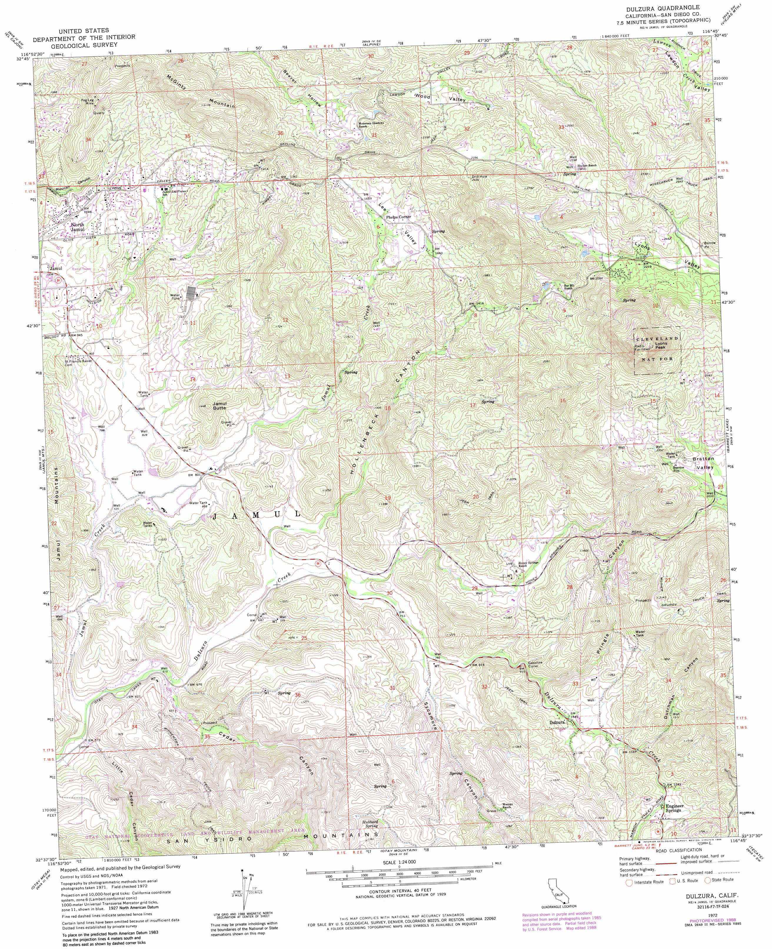
Dulzura Topo Map California
To zoom in, hover over the map of Dulzura
USGS Topo Quad 32116f7 - 1:24,000 scale
| Topo Map Name: | Dulzura |
| USGS Topo Quad ID: | 32116f7 |
| Print Size: | ca. 21 1/4" wide x 27" high |
| Southeast Coordinates: | 32.625° N latitude / 116.75° W longitude |
| Map Center Coordinates: | 32.6875° N latitude / 116.8125° W longitude |
| U.S. State: | CA |
| Filename: | o32116f7.jpg |
| Download Map JPG Image: | Dulzura topo map 1:24,000 scale |
| Map Type: | Topographic |
| Topo Series: | 7.5´ |
| Map Scale: | 1:24,000 |
| Source of Map Images: | United States Geological Survey (USGS) |
| Alternate Map Versions: |
Dulzura CA 1972, updated 1974 Download PDF Buy paper map Dulzura CA 1972, updated 1974 Download PDF Buy paper map Dulzura CA 1972, updated 1984 Download PDF Buy paper map Dulzura CA 1972, updated 1988 Download PDF Buy paper map Dulzura CA 1997, updated 2000 Download PDF Buy paper map Dulzura CA 2012 Download PDF Buy paper map Dulzura CA 2015 Download PDF Buy paper map |
| FStopo: | US Forest Service topo Dulzura is available: Download FStopo PDF Download FStopo TIF |
1:24,000 Topo Quads surrounding Dulzura
Poway |
San Vicente Reservoir |
El Cajon Mountain |
Tule Springs |
Cuyamaca Peak |
La Mesa |
El Cajon |
Alpine |
Viejas Mountain |
Descanso |
National City |
Jamul Mountains |
Dulzura |
Barrett Lake |
Morena Reservoir |
Imperial Beach |
Otay Mesa |
Otay Mountain |
Tecate |
Potrero |
> Back to 32116e1 at 1:100,000 scale
> Back to 32116a1 at 1:250,000 scale
> Back to U.S. Topo Maps home
Dulzura topo map: Gazetteer
Dulzura: Basins
Bratton Valley elevation 629m 2063′Dulzura: Mines
Peg Leg Mine elevation 484m 1587′Dulzura: Oilfields
Gasoline Curve elevation 280m 918′Dulzura: Populated Places
Dulzura elevation 321m 1053′Engineer Springs elevation 414m 1358′
Jamul Indian Village elevation 287m 941′
North Jamul elevation 313m 1026′
Phelps Corner elevation 501m 1643′
Dulzura: Springs
Hubbard Spring elevation 371m 1217′Dulzura: Streams
Dulzura Creek elevation 179m 587′Dulzura: Summits
Jamul Butte elevation 425m 1394′Lyons Peak elevation 1139m 3736′
Dulzura: Trails
California Riding and Hiking Trail elevation 490m 1607′Mother Grundy Truck Trail elevation 678m 2224′
Wisecarver Truck Trail elevation 814m 2670′
Dulzura: Valleys
Cedar Canyon elevation 191m 626′Dutchman Canyon elevation 355m 1164′
Hollenbeck Canyon elevation 222m 728′
Lawson Valley elevation 588m 1929′
Lee Valley elevation 475m 1558′
Little Cedar Canyon elevation 174m 570′
Lyons Valley elevation 647m 2122′
Pringle Canyon elevation 281m 921′
Sycamore Canyon elevation 236m 774′
Wood Valley elevation 472m 1548′
Dulzura digital topo map on disk
Buy this Dulzura topo map showing relief, roads, GPS coordinates and other geographical features, as a high-resolution digital map file on DVD: