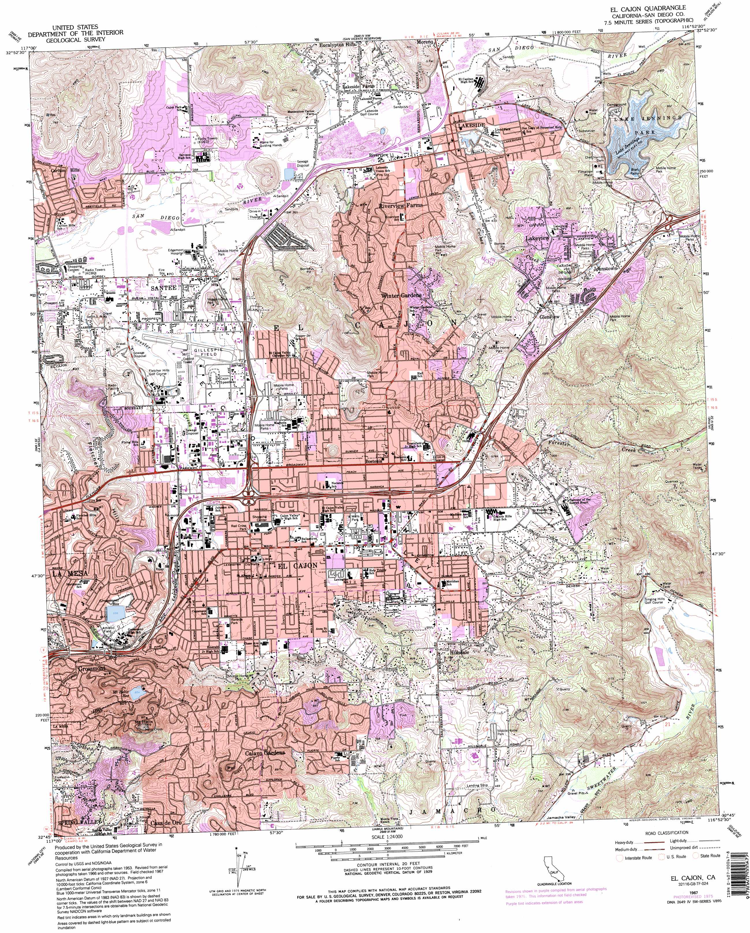
El Cajon Topo Map California
To zoom in, hover over the map of El Cajon
USGS Topo Quad 32116g8 - 1:24,000 scale
| Topo Map Name: | El Cajon |
| USGS Topo Quad ID: | 32116g8 |
| Print Size: | ca. 21 1/4" wide x 27" high |
| Southeast Coordinates: | 32.75° N latitude / 116.875° W longitude |
| Map Center Coordinates: | 32.8125° N latitude / 116.9375° W longitude |
| U.S. State: | CA |
| Filename: | o32116g8.jpg |
| Download Map JPG Image: | El Cajon topo map 1:24,000 scale |
| Map Type: | Topographic |
| Topo Series: | 7.5´ |
| Map Scale: | 1:24,000 |
| Source of Map Images: | United States Geological Survey (USGS) |
| Alternate Map Versions: |
El Cajon CA 1955, updated 1956 Download PDF Buy paper map El Cajon CA 1955, updated 1959 Download PDF Buy paper map El Cajon CA 1967, updated 1969 Download PDF Buy paper map El Cajon CA 1967, updated 1969 Download PDF Buy paper map El Cajon CA 1967, updated 1969 Download PDF Buy paper map El Cajon CA 1967, updated 1975 Download PDF Buy paper map El Cajon CA 1967, updated 1976 Download PDF Buy paper map El Cajon CA 1967, updated 1978 Download PDF Buy paper map El Cajon CA 1967, updated 1986 Download PDF Buy paper map El Cajon CA 1996, updated 2001 Download PDF Buy paper map El Cajon CA 2012 Download PDF Buy paper map El Cajon CA 2015 Download PDF Buy paper map |
1:24,000 Topo Quads surrounding El Cajon
Rancho Santa Fe |
Escondido |
San Pasqual |
Ramona |
Santa Ysabel |
Del Mar |
Poway |
San Vicente Reservoir |
El Cajon Mountain |
Tule Springs |
La Jolla |
La Mesa |
El Cajon |
Alpine |
Viejas Mountain |
Point Loma |
National City |
Jamul Mountains |
Dulzura |
Barrett Lake |
Imperial Beach |
Otay Mesa |
Otay Mountain |
Tecate |
> Back to 32116e1 at 1:100,000 scale
> Back to 32116a1 at 1:250,000 scale
> Back to U.S. Topo Maps home
El Cajon topo map: Gazetteer
El Cajon: Airports
Gillespie Field elevation 113m 370′Lamps Airport elevation 134m 439′
Scripps Hospital East County Heliport elevation 184m 603′
El Cajon: Crossings
Interchange 14C elevation 213m 698′Interchange 15 elevation 191m 626′
Interchange 16 elevation 152m 498′
Interchange 17A elevation 128m 419′
Interchange 17B elevation 129m 423′
Interchange 17C elevation 134m 439′
Interchange 18 elevation 140m 459′
Interchange 19 elevation 151m 495′
Interchange 20 elevation 189m 620′
Interchange 22 elevation 224m 734′
Interchange 23 elevation 210m 688′
El Cajon: Dams
Chet Harritt 56-009 Dam elevation 214m 702′Chet Harritt Dam elevation 199m 652′
El Cajon: Gaps
Eucalyptus Pass elevation 199m 652′Sweetwater Pass elevation 181m 593′
El Cajon: Lakes
Lindo Lake elevation 123m 403′El Cajon: Parks
Bill Beck City Park elevation 140m 459′Bostonia Park elevation 157m 515′
Cactus County Park elevation 126m 413′
Cottonwood One County Park elevation 207m 679′
Cottonwood Two County Park elevation 173m 567′
Damon Lane County Park elevation 165m 541′
Deputy Lonnie G Brewer County Park elevation 173m 567′
East San Diego County Fairgrounds elevation 118m 387′
El Cajon City Park elevation 134m 439′
Estrella County Park elevation 135m 442′
Fanita Ranch Sports Complex elevation 226m 741′
Fletcher Hills Open Space elevation 180m 590′
Fletcher Hills Park elevation 221m 725′
Harry Griffin Regional Park elevation 208m 682′
Hillside Park elevation 191m 626′
John F Kennedy Park elevation 161m 528′
Lake Jennings Park elevation 211m 692′
Lindo Lake Park elevation 122m 400′
Marshal Scottys Playland elevation 197m 646′
Mast Park elevation 101m 331′
North Town Center Park elevation 107m 351′
Northcote Park elevation 220m 721′
Padre Dam Park elevation 127m 416′
Polo Barn Park elevation 106m 347′
Radio Towers Park elevation 111m 364′
Red Cross Park elevation 132m 433′
Renette Park elevation 138m 452′
Rio Seco Ball Field elevation 105m 344′
River View Park elevation 134m 439′
Shadow Hill Park elevation 170m 557′
Town Center Ball Field elevation 104m 341′
Tuttle Park elevation 148m 485′
Van Zanten Park elevation 163m 534′
Wells Park elevation 142m 465′
Wildmere Park elevation 134m 439′
Woodglen Vista Park elevation 134m 439′
El Cajon: Populated Places
Alta (historical) elevation 197m 646′Bostonia elevation 148m 485′
Cajon Heights elevation 148m 485′
Calavo Gardens elevation 242m 793′
Camerons Mobile Home Park elevation 122m 400′
Carlton Hills elevation 128m 419′
El Cajon elevation 132m 433′
Glenview elevation 182m 597′
Granite Hills elevation 201m 659′
Grossmont elevation 206m 675′
Hawaiian Village Mobile Home Park elevation 107m 351′
Hillsdale elevation 170m 557′
Johnstown elevation 182m 597′
Lakeside elevation 126m 413′
Lakeside Farms elevation 119m 390′
Lakeview elevation 177m 580′
Mission del Magnolia Mobile Home Park elevation 109m 357′
Moreno elevation 144m 472′
Mount Helix elevation 341m 1118′
New Frontier Mobile Home Park elevation 107m 351′
Riverview elevation 120m 393′
Riverview Farms elevation 145m 475′
Santee elevation 107m 351′
Town and Country Mobile Home Park elevation 109m 357′
Winter Gardens elevation 206m 675′
El Cajon: Post Offices
Bostonia Post Office elevation 150m 492′El Cajon Post Office elevation 133m 436′
Lakeside Post Office elevation 127m 416′
Santee Post Office elevation 106m 347′
El Cajon: Ranges
Fletcher Hills elevation 254m 833′El Cajon: Reservoirs
Grassmont Reservoir elevation 199m 652′Lake Jennings elevation 215m 705′
Mount Helix Reservoir elevation 255m 836′
El Cajon: Streams
Los Coches Creek elevation 125m 410′San Vicente Creek elevation 123m 403′
El Cajon: Summits
Mount Helix elevation 416m 1364′El Cajon: Trails
Suncrest Truck Trail elevation 391m 1282′Valleyview Truck Trail elevation 367m 1204′
El Cajon: Tunnels
Lankesheim Tunnel (historical) elevation 230m 754′Los Coches Tunnel (historical) elevation 295m 967′
Monte Tunnel (historical) elevation 234m 767′
El Cajon: Valleys
El Cajon Valley elevation 101m 331′Moreno Valley elevation 123m 403′
Quail Canyon elevation 220m 721′
Rios Canyon elevation 202m 662′
El Cajon digital topo map on disk
Buy this El Cajon topo map showing relief, roads, GPS coordinates and other geographical features, as a high-resolution digital map file on DVD: