National City Topo Map California
To zoom in, hover over the map of National City
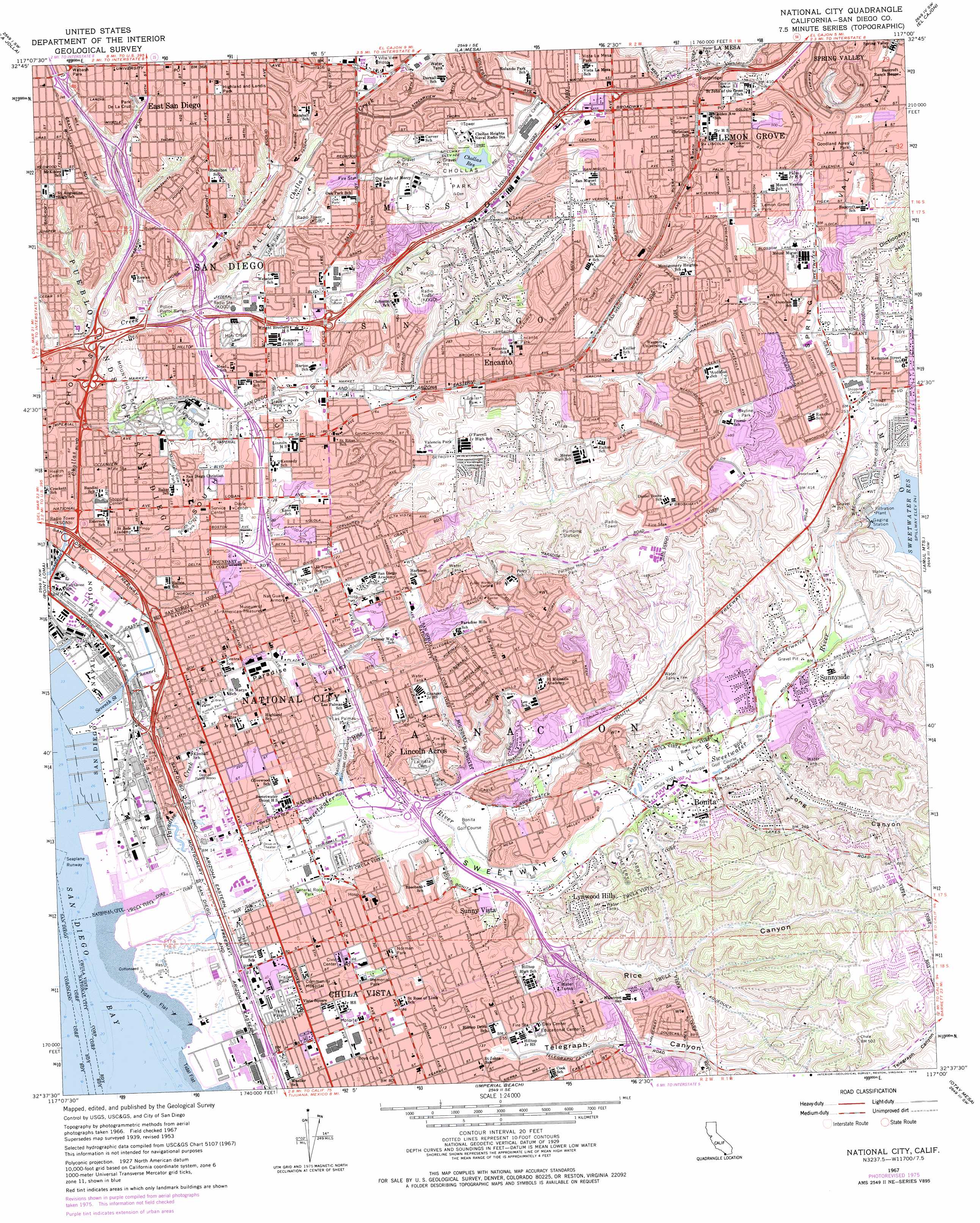
USGS Topo Quad 32117f1 - 1:24,000 scale
| Topo Map Name: | National City |
| USGS Topo Quad ID: | 32117f1 |
| Print Size: | ca. 21 1/4" wide x 27" high |
| Southeast Coordinates: | 32.625° N latitude / 117° W longitude |
| Map Center Coordinates: | 32.6875° N latitude / 117.0625° W longitude |
| U.S. State: | CA |
| Filename: | o32117f1.jpg |
| Download Map JPG Image: | National City topo map 1:24,000 scale |
| Map Type: | Topographic |
| Topo Series: | 7.5´ |
| Map Scale: | 1:24,000 |
| Source of Map Images: | United States Geological Survey (USGS) |
| Alternate Map Versions: |
National City CA 1953, updated 1955 Download PDF Buy paper map National City CA 1953, updated 1963 Download PDF Buy paper map National City CA 1967, updated 1970 Download PDF Buy paper map National City CA 1967, updated 1978 Download PDF Buy paper map National City CA 1967, updated 1978 Download PDF Buy paper map National City CA 1996, updated 2001 Download PDF Buy paper map National City CA 2012 Download PDF Buy paper map National City CA 2015 Download PDF Buy paper map |
1:24,000 Topo Quads surrounding National City
Del Mar |
Poway |
San Vicente Reservoir |
El Cajon Mountain |
|
La Jolla |
La Mesa |
El Cajon |
Alpine |
|
Point Loma |
National City |
Jamul Mountains |
Dulzura |
|
Imperial Beach |
Otay Mesa |
Otay Mountain |
||
> Back to 32117e1 at 1:100,000 scale
> Back to 32116a1 at 1:250,000 scale
> Back to U.S. Topo Maps home
National City topo map: Gazetteer
National City: Airports
KGTV-10 Parking Lot Heliport elevation 66m 216′Paradise Valley Hospital Heliport elevation 31m 101′
National City: Canals
Seventh Street Channel elevation 4m 13′Sweetwater Channel elevation 4m 13′
National City: Capes
Gunpowder Point elevation 4m 13′National City: Crossings
Interchange 10 elevation 3m 9′Interchange 10 elevation 22m 72′
Interchange 11A elevation 7m 22′
Interchange 11A elevation 23m 75′
Interchange 11B elevation 13m 42′
Interchange 11B elevation 28m 91′
Interchange 12 elevation 7m 22′
Interchange 12A elevation 32m 104′
Interchange 12B elevation 45m 147′
Interchange 13A elevation 50m 164′
Interchange 13A elevation 11m 36′
Interchange 13B elevation 41m 134′
Interchange 14 elevation 51m 167′
Interchange 15 elevation 102m 334′
Interchange 1A elevation 6m 19′
Interchange 1B elevation 5m 16′
Interchange 1C elevation 6m 19′
Interchange 1D elevation 9m 29′
Interchange 2A elevation 29m 95′
Interchange 2B elevation 24m 78′
Interchange 3 elevation 68m 223′
Interchange 5A elevation 111m 364′
Interchange 6 elevation 65m 213′
Interchange 7 elevation 13m 42′
Interchange 8 elevation 10m 32′
Interchange 8A elevation 7m 22′
Interchange 8B elevation 7m 22′
Interchange 9 elevation 4m 13′
Interchange 9 elevation 9m 29′
National City: Dams
Chollas 8-002 Dam elevation 130m 426′Sweetwater Main 2020 Dam elevation 55m 180′
National City: Parks
Azalea Park elevation 75m 246′Bancroft City Park elevation 118m 387′
Bay Terrace Park and Recreation Center elevation 73m 239′
Bayside Park elevation 4m 13′
Berry City Park elevation 136m 446′
Bonita Long Canyon Park elevation 74m 242′
Boone Park elevation 128m 419′
Chollas Park elevation 136m 446′
Chula Vista Recreation Center elevation 21m 68′
City Heights Community Recreation Center elevation 111m 364′
Dennis V Allen Park elevation 44m 144′
Discovery Park elevation 120m 393′
El Rancho del Rey Park elevation 140m 459′
El Toyon Park elevation 31m 101′
Emerald Hills Park elevation 98m 321′
Encantato Park elevation 74m 242′
Encanto Park elevation 92m 301′
Encanto Park Recreation Center elevation 91m 298′
Firemens Park elevation 134m 439′
Fred H Rohr Elementary School elevation 24m 78′
General Roca Park elevation 6m 19′
Gompers Park elevation 57m 187′
Goodland Acres Park elevation 102m 334′
Halecrest Park elevation 100m 328′
Highland and Lands Park elevation 111m 364′
Hilltop Park elevation 44m 144′
Hollywood Park elevation 77m 252′
Independence Park elevation 128m 419′
John F Kennedy Park elevation 28m 91′
Keiller Park elevation 97m 318′
Kimball Park elevation 6m 19′
Lamar County Park elevation 107m 351′
Las Palmas Park elevation 18m 59′
Lemon Grove Park elevation 136m 446′
Library Park elevation 23m 75′
Lincoln Acres County Park elevation 51m 167′
Lomita Park elevation 130m 426′
Martin Luther King Junior Memorial Park elevation 127m 416′
Memorial Park elevation 19m 62′
Monterey Heights County Park elevation 118m 387′
Mountain View Park elevation 24m 78′
Norman Park elevation 26m 85′
Oak Park elevation 79m 259′
Paradise Hills Park elevation 102m 334′
Paradise Valley Park and Recreation Center elevation 53m 173′
Park De La Cruz elevation 84m 275′
Parkside Park elevation 49m 160′
Paseo del Ray Park elevation 87m 285′
Penn Athletic Area elevation 68m 223′
Pepper Park elevation 4m 13′
Rohr Park elevation 27m 88′
Skyline Park elevation 140m 459′
Skyline Park Recreation Center elevation 137m 449′
Skyview Park elevation 144m 472′
South Crest Park elevation 8m 26′
South Crest Recreation Center elevation 10m 32′
Spring Valley County Park elevation 81m 265′
Summit Park elevation 97m 318′
Sunridge Park elevation 148m 485′
Sweetwater Heights Park elevation 50m 164′
Sweetwater Lane City Park elevation 98m 321′
Sweetwater Marsh National Wildlife Refuge elevation 4m 13′
Sweetwater Regional Park elevation 28m 91′
Terra Nova Park elevation 84m 275′
Vista La Mesa Park elevation 142m 465′
Wabash Park elevation 105m 344′
Willie Henderson Sports Complex elevation 25m 82′
National City: Populated Places
Bonita elevation 36m 118′Chollas Creek elevation 84m 275′
Chollas View elevation 52m 170′
Chula Vista elevation 21m 68′
East San Diego elevation 111m 364′
Emerald Hills elevation 52m 170′
Encanto elevation 81m 265′
Lemon Grove elevation 136m 446′
Lincoln Acres elevation 48m 157′
Lincoln Park elevation 47m 154′
Lomita elevation 121m 396′
Lynwood Hills elevation 68m 223′
Mount Hope elevation 51m 167′
Mountain View elevation 28m 91′
National City elevation 21m 68′
North Bay Terraces elevation 116m 380′
Paradise Hills elevation 95m 311′
Rancho del Rey elevation 141m 462′
Shelltown elevation 17m 55′
South Bay Terraces elevation 89m 291′
South Crest elevation 7m 22′
South Encantato elevation 87m 285′
Stockton elevation 26m 85′
Sunny Vista elevation 39m 127′
Sunnyside elevation 36m 118′
Valencia Park elevation 55m 180′
National City: Post Offices
Chula Vista Post Office elevation 19m 62′City Heights Post Office elevation 112m 367′
College Grove Center Post Office elevation 134m 439′
Lemon Grove Post Office elevation 139m 456′
National City Post Office elevation 16m 52′
Paradise Hills Post Office elevation 62m 203′
National City: Reservoirs
Chollas Reservoir elevation 130m 426′Sweetwater Reservoir elevation 55m 180′
National City: Streams
Paradise Creek elevation 4m 13′Sweetwater River elevation 4m 13′
National City: Swamps
Sweetwater Marsh elevation 4m 13′National City: Valleys
Long Canyon elevation 29m 95′Paradise Valley elevation 4m 13′
Rice Canyon elevation 13m 42′
South Chollas Valley elevation 4m 13′
Spring Valley elevation 51m 167′
Sweetwater Valley elevation 4m 13′
National City digital topo map on disk
Buy this National City topo map showing relief, roads, GPS coordinates and other geographical features, as a high-resolution digital map file on DVD: