Longs Topo Map South Carolina
To zoom in, hover over the map of Longs
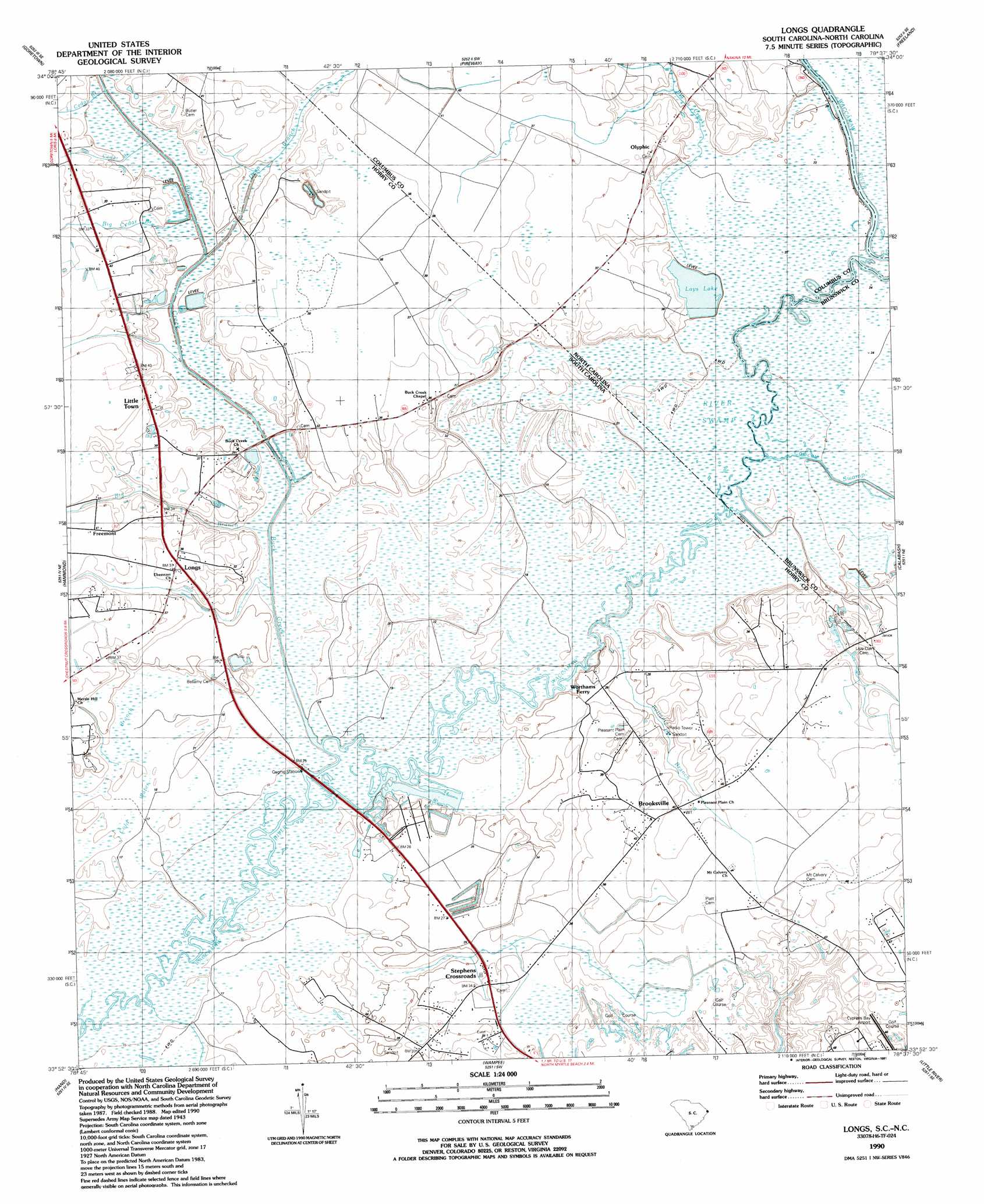
USGS Topo Quad 33078h6 - 1:24,000 scale
| Topo Map Name: | Longs |
| USGS Topo Quad ID: | 33078h6 |
| Print Size: | ca. 21 1/4" wide x 27" high |
| Southeast Coordinates: | 33.875° N latitude / 78.625° W longitude |
| Map Center Coordinates: | 33.9375° N latitude / 78.6875° W longitude |
| U.S. States: | SC, NC |
| Filename: | o33078h6.jpg |
| Download Map JPG Image: | Longs topo map 1:24,000 scale |
| Map Type: | Topographic |
| Topo Series: | 7.5´ |
| Map Scale: | 1:24,000 |
| Source of Map Images: | United States Geological Survey (USGS) |
| Alternate Map Versions: |
Longs SC 1953 Download PDF Buy paper map Longs SC 1990, updated 1991 Download PDF Buy paper map Longs SC 2011 Download PDF Buy paper map Longs SC 2014 Download PDF Buy paper map |
1:24,000 Topo Quads surrounding Longs
Tabor City West |
Tabor City East |
Nakina |
Old Dock |
Juniper Creek |
Loris |
Goretown |
Pireway |
Freeland |
Exum |
Shell |
Hammond |
Longs |
Calabash |
Shallotte |
Nixonville |
Hand |
Wampee |
Little River |
|
Myrtle Beach |
Ocean Forest |
> Back to 33078e1 at 1:100,000 scale
> Back to 33078a1 at 1:250,000 scale
> Back to U.S. Topo Maps home
Longs topo map: Gazetteer
Longs: Airports
Cypress Bay Airport elevation 13m 42′Longs: Bridges
Big Branch Bridge elevation 8m 26′Big Creek Bridge elevation 7m 22′
Buck Creek Bridge elevation 6m 19′
Deep Branch Bridge elevation 7m 22′
Indigo Bridge elevation 8m 26′
Waccamaw Bridges elevation 6m 19′
Longs: Populated Places
Brooksville elevation 12m 39′Freemont elevation 13m 42′
Little Town elevation 12m 39′
Longs elevation 10m 32′
Olyphic elevation 12m 39′
Stephens Crossroads elevation 10m 32′
Worthams Ferry elevation 10m 32′
Longs: Post Offices
Longs Post Office elevation 11m 36′Olyphic Post Office elevation 9m 29′
Longs: Streams
Bellamy Branch elevation 4m 13′Big Cedar Branch elevation 7m 22′
Big Cedar Branch elevation 6m 19′
Big Creek elevation 6m 19′
Buck Creek elevation 6m 19′
Cawcaw Swamp elevation 5m 16′
Cold Water Branch elevation 4m 13′
Deep Branch elevation 6m 19′
Deep Branch elevation 6m 19′
Donford Branch elevation 7m 22′
Indigo Branch elevation 6m 19′
Little Cedar Branch elevation 7m 22′
Little Cedar Pond elevation 7m 22′
Marlow Branch elevation 6m 19′
Scippio Swamp elevation 7m 22′
Longs: Swamps
Baker Bay elevation 10m 32′River Swamp elevation 5m 16′
Longs digital topo map on disk
Buy this Longs topo map showing relief, roads, GPS coordinates and other geographical features, as a high-resolution digital map file on DVD:
South Carolina, Western North Carolina & Northeastern Georgia
Buy digital topo maps: South Carolina, Western North Carolina & Northeastern Georgia