Mcclellanville Topo Map South Carolina
To zoom in, hover over the map of Mcclellanville
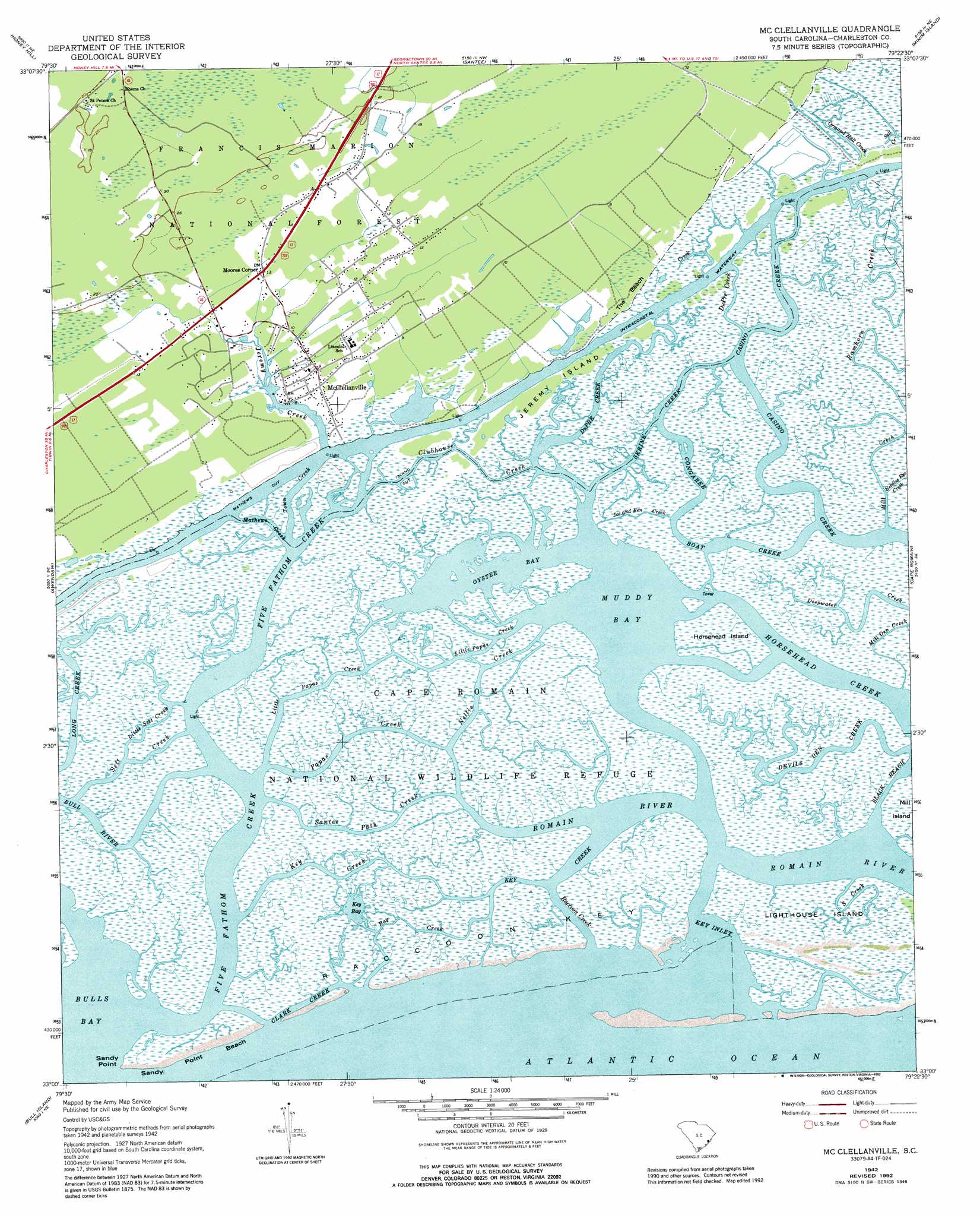
USGS Topo Quad 33079a4 - 1:24,000 scale
| Topo Map Name: | Mcclellanville |
| USGS Topo Quad ID: | 33079a4 |
| Print Size: | ca. 21 1/4" wide x 27" high |
| Southeast Coordinates: | 33° N latitude / 79.375° W longitude |
| Map Center Coordinates: | 33.0625° N latitude / 79.4375° W longitude |
| U.S. State: | SC |
| Filename: | o33079a4.jpg |
| Download Map JPG Image: | Mcclellanville topo map 1:24,000 scale |
| Map Type: | Topographic |
| Topo Series: | 7.5´ |
| Map Scale: | 1:24,000 |
| Source of Map Images: | United States Geological Survey (USGS) |
| Alternate Map Versions: |
Mc Clellanville SC 1942, updated 1962 Download PDF Buy paper map Mc Clellanville SC 1942, updated 1976 Download PDF Buy paper map Mc Clellanville SC 1942, updated 1976 Download PDF Buy paper map Mc Clellanville SC 1942, updated 1989 Download PDF Buy paper map Mc Clellanville SC 1942, updated 1992 Download PDF Buy paper map McClellanville SC 2011 Download PDF Buy paper map McClellanville SC 2014 Download PDF Buy paper map |
| FStopo: | US Forest Service topo McClellanville is available: Download FStopo PDF Download FStopo TIF |
1:24,000 Topo Quads surrounding Mcclellanville
Jamestown |
Cedar Creek |
Kilsock Bay |
Georgetown South |
North Island |
Shulerville |
Honey Hill |
Santee |
Minim Island |
Santee Point |
Ocean Bay |
Awendaw |
Mcclellanville |
Cape Romain |
|
Sewee Bay |
Bull Island |
|||
Capers Inlet |
> Back to 33079a1 at 1:100,000 scale
> Back to 33078a1 at 1:250,000 scale
> Back to U.S. Topo Maps home
Mcclellanville topo map: Gazetteer
Mcclellanville: Bays
Key Bay elevation 0m 0′Muddy Bay elevation 0m 0′
Oyster Bay elevation 0m 0′
Mcclellanville: Beaches
Sandy Point Beach elevation 0m 0′Mcclellanville: Capes
Sandy Point elevation 0m 0′Mcclellanville: Channels
Island Cut elevation 0m 0′Mathews Cut elevation 0m 0′
Slack Reach elevation 0m 0′
Mcclellanville: Guts
Bay Creek elevation 1m 3′Bull River elevation 0m 0′
Casino Creek elevation 0m 0′
Clark Creek elevation 0m 0′
Clubhouse Creek elevation 0m 0′
Congaree Boat Creek elevation 0m 0′
DuPre Creek elevation 1m 3′
Dupre Creek elevation 0m 0′
DuPre Creek elevation 0m 0′
Five Fathom Creek elevation 0m 0′
Horsehead Creek elevation 0m 0′
Joe and Ben Creek elevation 1m 3′
Key Creek elevation 0m 0′
Key Inlet elevation 0m 0′
Little Papas Creek elevation 1m 3′
Mathews Creek elevation 0m 0′
Mill Creek elevation 1m 3′
Mill Den Creek elevation 1m 3′
Nellie Creek elevation 0m 0′
Papas Creek elevation 0m 0′
Raccoon Creek elevation 0m 0′
Ramhorn Creek elevation 0m 0′
Santee Path Creek elevation 1m 3′
Skrine Creek elevation 0m 0′
Town Creek elevation 0m 0′
Mcclellanville: Islands
Horsehead Island elevation 1m 3′Jeremy Island elevation 1m 3′
Lighthouse Island elevation 0m 0′
Raccoon Key elevation 1m 3′
Mcclellanville: Parks
McClellanville Historic District elevation 1m 3′Mcclellanville: Populated Places
McClellanville elevation 1m 3′Moores Corner elevation 4m 13′
Mcclellanville: Streams
Devils Den Creek elevation 0m 0′Jeremy Creek elevation 0m 0′
Little Sett Creek elevation 0m 0′
Needles Eye Creek elevation 1m 3′
Ormand Hall Creek elevation 1m 3′
Sall Creek elevation 1m 3′
Sett Creek elevation 0m 0′
South Creek elevation 0m 0′
Mcclellanville digital topo map on disk
Buy this Mcclellanville topo map showing relief, roads, GPS coordinates and other geographical features, as a high-resolution digital map file on DVD:
South Carolina, Western North Carolina & Northeastern Georgia
Buy digital topo maps: South Carolina, Western North Carolina & Northeastern Georgia