Ocean Bay Topo Map South Carolina
To zoom in, hover over the map of Ocean Bay
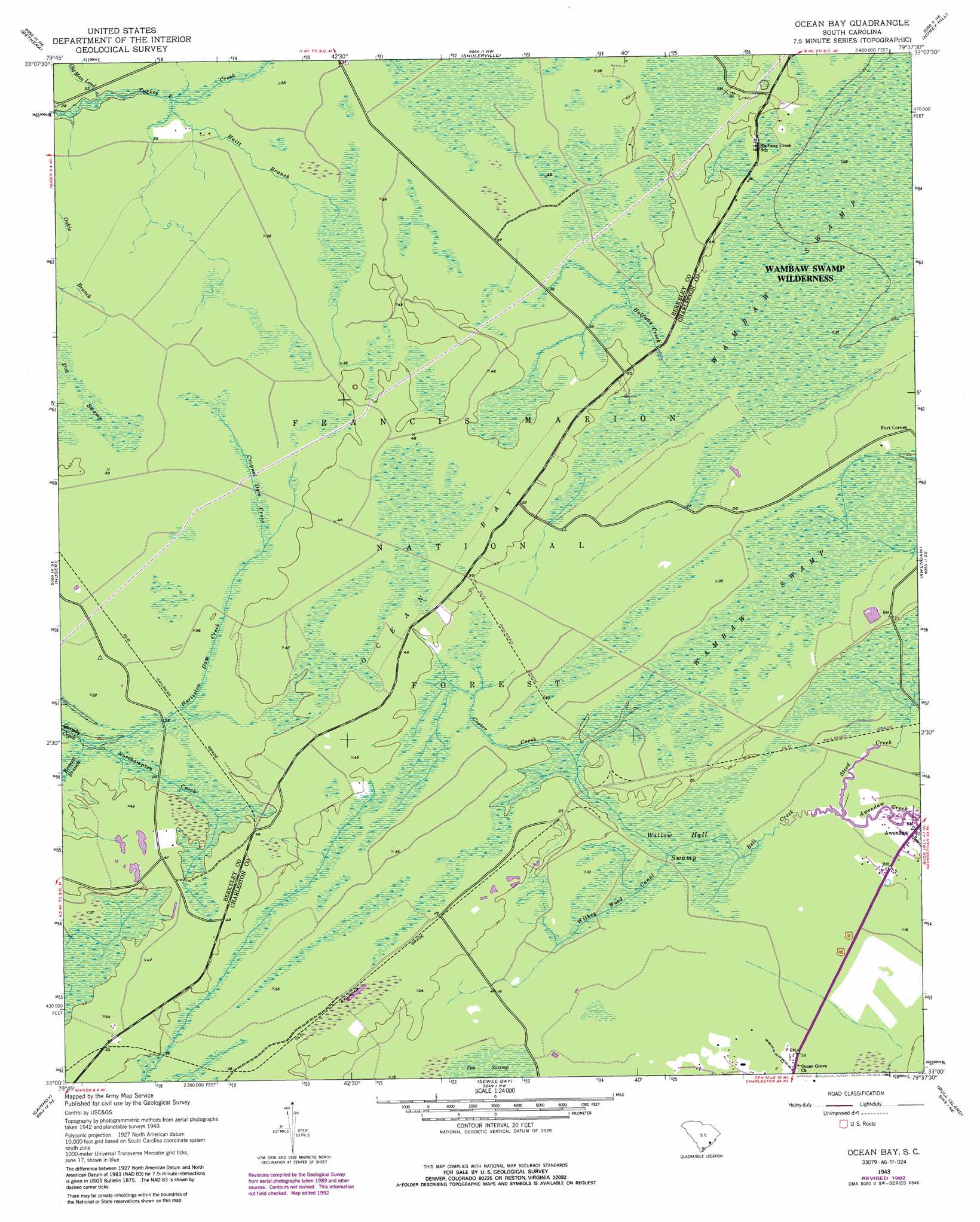
USGS Topo Quad 33079a6 - 1:24,000 scale
| Topo Map Name: | Ocean Bay |
| USGS Topo Quad ID: | 33079a6 |
| Print Size: | ca. 21 1/4" wide x 27" high |
| Southeast Coordinates: | 33° N latitude / 79.625° W longitude |
| Map Center Coordinates: | 33.0625° N latitude / 79.6875° W longitude |
| U.S. State: | SC |
| Filename: | o33079a6.jpg |
| Download Map JPG Image: | Ocean Bay topo map 1:24,000 scale |
| Map Type: | Topographic |
| Topo Series: | 7.5´ |
| Map Scale: | 1:24,000 |
| Source of Map Images: | United States Geological Survey (USGS) |
| Alternate Map Versions: |
Ocean Bay SC 1943, updated 1962 Download PDF Buy paper map Ocean Bay SC 1943, updated 1976 Download PDF Buy paper map Ocean Bay SC 1943, updated 1989 Download PDF Buy paper map Ocean Bay SC 1943, updated 1992 Download PDF Buy paper map Ocean Bay SC 2011 Download PDF Buy paper map Ocean Bay SC 2014 Download PDF Buy paper map |
| FStopo: | US Forest Service topo Ocean Bay is available: Download FStopo PDF Download FStopo TIF |
1:24,000 Topo Quads surrounding Ocean Bay
Bonneau |
Wedboo Creek |
Jamestown |
Cedar Creek |
Kilsock Bay |
Cordesville |
Bethera |
Shulerville |
Honey Hill |
Santee |
Kittredge |
Huger |
Ocean Bay |
Awendaw |
Mcclellanville |
North Charleston |
Cainhoy |
Sewee Bay |
Bull Island |
|
Charleston |
Fort Moultrie |
Capers Inlet |
> Back to 33079a1 at 1:100,000 scale
> Back to 33078a1 at 1:250,000 scale
> Back to U.S. Topo Maps home
Ocean Bay topo map: Gazetteer
Ocean Bay: Basins
Ocean Bay elevation 13m 42′Ocean Bay: Lakes
Fish Pond elevation 6m 19′Ocean Bay: Populated Places
Fort Corner elevation 9m 29′Halfway Creek elevation 12m 39′
Ocean Bay: Reservoirs
Lake Awendaw elevation 5m 16′Ocean Bay: Streams
Bell Creek elevation 5m 16′Bennett Branch elevation 6m 19′
Cooter Creek elevation 5m 16′
Cropnel Dam Creek elevation 12m 39′
Halfway Creek elevation 12m 39′
Harleston Dam Creek elevation 6m 19′
Huitt Branch elevation 7m 22′
Northampton Creek elevation 6m 19′
Oakie Branch elevation 11m 36′
Oakie Branch elevation 8m 26′
Old Man Lead elevation 5m 16′
Steed Creek elevation 5m 16′
Withey Wood Canal elevation 5m 16′
Ocean Bay: Swamps
Dog Swamp elevation 10m 32′King Swamp elevation 13m 42′
Willow Hall Swamp elevation 5m 16′
Ocean Bay: Trails
Swamp Fox Trail elevation 12m 39′Ocean Bay digital topo map on disk
Buy this Ocean Bay topo map showing relief, roads, GPS coordinates and other geographical features, as a high-resolution digital map file on DVD:
South Carolina, Western North Carolina & Northeastern Georgia
Buy digital topo maps: South Carolina, Western North Carolina & Northeastern Georgia