Kittredge Topo Map South Carolina
To zoom in, hover over the map of Kittredge
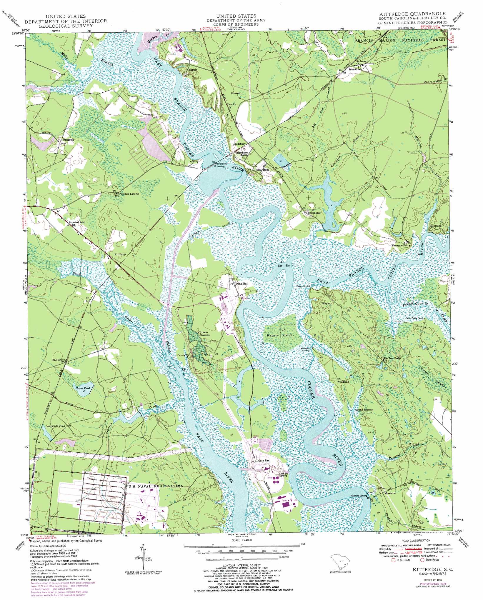
USGS Topo Quad 33079a8 - 1:24,000 scale
| Topo Map Name: | Kittredge |
| USGS Topo Quad ID: | 33079a8 |
| Print Size: | ca. 21 1/4" wide x 27" high |
| Southeast Coordinates: | 33° N latitude / 79.875° W longitude |
| Map Center Coordinates: | 33.0625° N latitude / 79.9375° W longitude |
| U.S. State: | SC |
| Filename: | o33079a8.jpg |
| Download Map JPG Image: | Kittredge topo map 1:24,000 scale |
| Map Type: | Topographic |
| Topo Series: | 7.5´ |
| Map Scale: | 1:24,000 |
| Source of Map Images: | United States Geological Survey (USGS) |
| Alternate Map Versions: |
Kittredge SC 1950 Download PDF Buy paper map Kittredge SC 1950, updated 1973 Download PDF Buy paper map Kittredge SC 1950, updated 1979 Download PDF Buy paper map Kittredge SC 2011 Download PDF Buy paper map Kittredge SC 2014 Download PDF Buy paper map |
| FStopo: | US Forest Service topo Kittredge is available: Download FStopo PDF Download FStopo TIF |
1:24,000 Topo Quads surrounding Kittredge
Cross |
Chicora |
Bonneau |
Wedboo Creek |
Jamestown |
Summerville Nw |
Moncks Corner |
Cordesville |
Bethera |
Shulerville |
Summerville |
Mount Holly |
Kittredge |
Huger |
Ocean Bay |
Stallsville |
Ladson |
North Charleston |
Cainhoy |
Sewee Bay |
Ravenel |
Johns Island |
Charleston |
Fort Moultrie |
Capers Inlet |
> Back to 33079a1 at 1:100,000 scale
> Back to 33078a1 at 1:250,000 scale
> Back to U.S. Topo Maps home
Kittredge topo map: Gazetteer
Kittredge: Dams
Lake Legendre Dam D-3478 elevation 4m 13′Legendre Headquarters Pond Dam D-3476 elevation 1m 3′
Reeves Telecom Pond Number One Dam D-3479 elevation 2m 6′
South Carolina Noname 08013 D-3470 Dam elevation 5m 16′
South Carolina Noname 08015 Dam elevation 5m 16′
South Carolina Noname 08024 D-3471 Dam elevation 2m 6′
Kittredge: Islands
Hagan Island elevation 1m 3′Kittredge: Lakes
Coingtee Lake elevation 1m 3′Kittredge: Parks
Cypress Gardens elevation 2m 6′Kittredge: Populated Places
Cedar Creek Landing elevation 1m 3′Childsbury elevation 8m 26′
Comingtee elevation 10m 32′
Cote Bas Landing elevation 3m 9′
Ellwood elevation 13m 42′
Hagan elevation 9m 29′
Hagan Landing elevation 7m 22′
Kittredge elevation 5m 16′
Mepkin elevation 9m 29′
Moreland elevation 3m 9′
Moreland Landing elevation 0m 0′
Pimlico elevation 2m 6′
Pine Grove elevation 9m 29′
Rice Hope elevation 9m 29′
Richmond elevation 9m 29′
Saw Mill elevation 13m 42′
Stokes (historical) elevation 10m 32′
Strawberry Landing elevation 2m 6′
Tarry Town elevation 8m 26′
Wappoola elevation 9m 29′
Woodland elevation 3m 9′
Woodland Landing elevation 1m 3′
Kittredge: Reservoirs
Bonnie Reserve elevation 1m 3′Crane Pond elevation 5m 16′
Long Field Pond elevation 5m 16′
Rice Hope Lake elevation 2m 6′
Kittredge: Streams
Big Dam Lead elevation 2m 6′Chicken Creek elevation 0m 0′
Comingtee Creek elevation 0m 0′
Durham Creek elevation 1m 3′
East Branch Cooper River elevation 0m 0′
French Quarter Creek elevation 1m 3′
Freshing Lead elevation 0m 0′
Mayrant Lead elevation 1m 3′
Mepkin Creek elevation 0m 0′
Molly Branch elevation 0m 0′
Prioleau Creek elevation 1m 3′
West Branch Cooper River elevation 0m 0′
Kittredge digital topo map on disk
Buy this Kittredge topo map showing relief, roads, GPS coordinates and other geographical features, as a high-resolution digital map file on DVD:
South Carolina, Western North Carolina & Northeastern Georgia
Buy digital topo maps: South Carolina, Western North Carolina & Northeastern Georgia