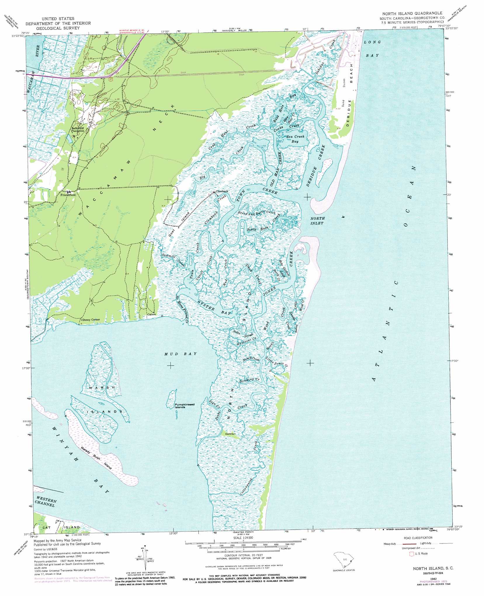
North Island Topo Map South Carolina
To zoom in, hover over the map of North Island
USGS Topo Quad 33079c2 - 1:24,000 scale
| Topo Map Name: | North Island |
| USGS Topo Quad ID: | 33079c2 |
| Print Size: | ca. 21 1/4" wide x 27" high |
| Southeast Coordinates: | 33.25° N latitude / 79.125° W longitude |
| Map Center Coordinates: | 33.3125° N latitude / 79.1875° W longitude |
| U.S. State: | SC |
| Filename: | o33079c2.jpg |
| Download Map JPG Image: | North Island topo map 1:24,000 scale |
| Map Type: | Topographic |
| Topo Series: | 7.5´ |
| Map Scale: | 1:24,000 |
| Source of Map Images: | United States Geological Survey (USGS) |
| Alternate Map Versions: |
North Island SC 1942, updated 1962 Download PDF Buy paper map North Island SC 1942, updated 1976 Download PDF Buy paper map North Island SC 1942, updated 1986 Download PDF Buy paper map North Island SC 2011 Download PDF Buy paper map North Island SC 2014 Download PDF Buy paper map |
1:24,000 Topo Quads surrounding North Island
Rhems |
Carvers Bay |
Plantersville |
Brookgreen |
Surfside Beach |
Olin |
Georgetown North |
Waverly Mills |
Magnolia Beach |
|
Kilsock Bay |
Georgetown South |
North Island |
||
Santee |
Minim Island |
Santee Point |
||
Mcclellanville |
Cape Romain |
> Back to 33079a1 at 1:100,000 scale
> Back to 33078a1 at 1:250,000 scale
> Back to U.S. Topo Maps home
North Island topo map: Gazetteer
North Island: Bays
Bass Hole Bay elevation -10m -33′Mud Bay elevation 0m 0′
North Inlet elevation 0m 0′
Oyster Bay elevation 0m 0′
Sea Creek Bay elevation 0m 0′
Winyah Bay elevation 0m 0′
North Island: Capes
Waccamaw Neck elevation 5m 16′North Island: Channels
Yahany Inlet (historical) elevation 1m 3′North Island: Guts
Bass Hole Creek elevation 0m 0′Bobs Garden Creek elevation 1m 3′
Boor Creek elevation 1m 3′
Bread and Butter Creek elevation 1m 3′
Clambank Creek elevation 1m 3′
Cooks Creek elevation -7m -23′
Cutoff Creek elevation 1m 3′
Dividing Creek elevation 1m 3′
Double Prong Creek elevation 1m 3′
Duck Creek elevation 1m 3′
Haulover Creek elevation 1m 3′
Jones Creek elevation 1m 3′
Little Jones Creek elevation 1m 3′
Mud Creek elevation 1m 3′
Nancy Creek elevation 1m 3′
No Mans Friend Creek elevation 1m 3′
Noble Slough elevation 1m 3′
Old Man Creek elevation 0m 0′
Perry Creek elevation 1m 3′
Sawmill Creek elevation 1m 3′
Sign Creek elevation 1m 3′
Sixty Bass Creek elevation 1m 3′
Town Creek elevation 0m 0′
Wood Creek elevation 1m 3′
North Island: Islands
Big Marsh Island elevation 1m 3′Collins Island elevation 1m 3′
Debidue Island elevation 1m 3′
Goat Island elevation 2m 6′
Malady Bush Island elevation 1m 3′
Marsh Island elevation 1m 3′
Marsh Islands elevation 0m 0′
North Island elevation 1m 3′
Pumpkinseed Islands elevation 1m 3′
North Island: Parks
Baruch-North Island Reserve elevation 1m 3′North Island: Populated Places
Caines elevation 1m 3′Clambank elevation 1m 3′
De Bordieu elevation 1m 3′
De Bordieu Colony elevation 1m 3′
DeBordieu elevation 1m 3′
Denny Corner elevation 1m 3′
Friendfield elevation 4m 13′
North Island: Streams
Bly Creek elevation 0m 0′Cottonpatch Creek elevation 1m 3′
Crab Haul Creek elevation 0m 0′
Debidue Creek elevation 0m 0′
Little Wood Creek elevation 1m 3′
North Island digital topo map on disk
Buy this North Island topo map showing relief, roads, GPS coordinates and other geographical features, as a high-resolution digital map file on DVD:
South Carolina, Western North Carolina & Northeastern Georgia
Buy digital topo maps: South Carolina, Western North Carolina & Northeastern Georgia