Cedar Creek Topo Map South Carolina
To zoom in, hover over the map of Cedar Creek
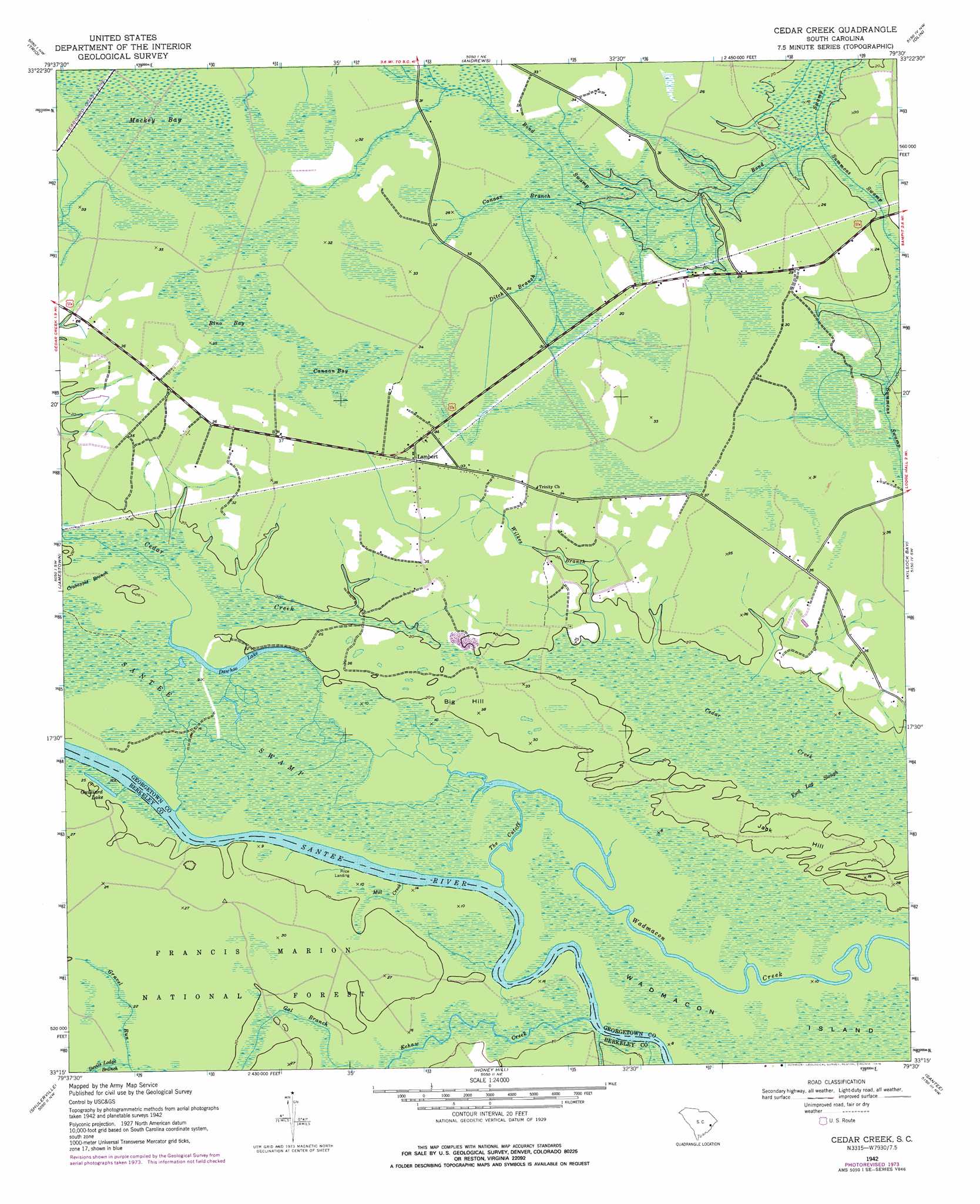
USGS Topo Quad 33079c5 - 1:24,000 scale
| Topo Map Name: | Cedar Creek |
| USGS Topo Quad ID: | 33079c5 |
| Print Size: | ca. 21 1/4" wide x 27" high |
| Southeast Coordinates: | 33.25° N latitude / 79.5° W longitude |
| Map Center Coordinates: | 33.3125° N latitude / 79.5625° W longitude |
| U.S. State: | SC |
| Filename: | o33079c5.jpg |
| Download Map JPG Image: | Cedar Creek topo map 1:24,000 scale |
| Map Type: | Topographic |
| Topo Series: | 7.5´ |
| Map Scale: | 1:24,000 |
| Source of Map Images: | United States Geological Survey (USGS) |
| Alternate Map Versions: |
Cedar Creek SC 1942, updated 1962 Download PDF Buy paper map Cedar Creek SC 1942, updated 1976 Download PDF Buy paper map Cedar Creek SC 2011 Download PDF Buy paper map Cedar Creek SC 2014 Download PDF Buy paper map |
| FStopo: | US Forest Service topo Cedar Creek is available: Download FStopo PDF Download FStopo TIF |
1:24,000 Topo Quads surrounding Cedar Creek
Salters |
Kellehan Crossroads |
Warsaw |
Rhems |
Carvers Bay |
Blakely |
Trio |
Andrews |
Olin |
Georgetown North |
Wedboo Creek |
Jamestown |
Cedar Creek |
Kilsock Bay |
Georgetown South |
Bethera |
Shulerville |
Honey Hill |
Santee |
Minim Island |
Huger |
Ocean Bay |
Awendaw |
Mcclellanville |
Cape Romain |
> Back to 33079a1 at 1:100,000 scale
> Back to 33078a1 at 1:250,000 scale
> Back to U.S. Topo Maps home
Cedar Creek topo map: Gazetteer
Cedar Creek: Guts
Foot Log Slough elevation 3m 9′Cedar Creek: Islands
Wadmacon Island elevation 3m 9′Cedar Creek: Lakes
Dawhoo Lake elevation 5m 16′Guilliard Lake elevation 5m 16′
Cedar Creek: Populated Places
Lambert elevation 9m 29′Price Landing elevation 4m 13′
Cedar Creek: Ridges
Big Hill elevation 7m 22′Jack Hill elevation 6m 19′
Cedar Creek: Streams
Canaan Branch elevation 6m 19′Crabapple Branch elevation 3m 9′
Ditch Branch elevation 8m 26′
Echaw Creek elevation 0m 0′
Gal Branch elevation 6m 19′
Mill Creek elevation 0m 0′
Put-on Branch elevation 4m 13′
Summons Swamp elevation 4m 13′
The Cutoff elevation 3m 9′
Wilkes Branch elevation 5m 16′
Cedar Creek: Swamps
Bino Bay elevation 9m 29′Canaan Bay elevation 9m 29′
Mackey Bay elevation 9m 29′
Santee Swamp elevation 3m 9′
Cedar Creek digital topo map on disk
Buy this Cedar Creek topo map showing relief, roads, GPS coordinates and other geographical features, as a high-resolution digital map file on DVD:
South Carolina, Western North Carolina & Northeastern Georgia
Buy digital topo maps: South Carolina, Western North Carolina & Northeastern Georgia