Jamestown Topo Map South Carolina
To zoom in, hover over the map of Jamestown
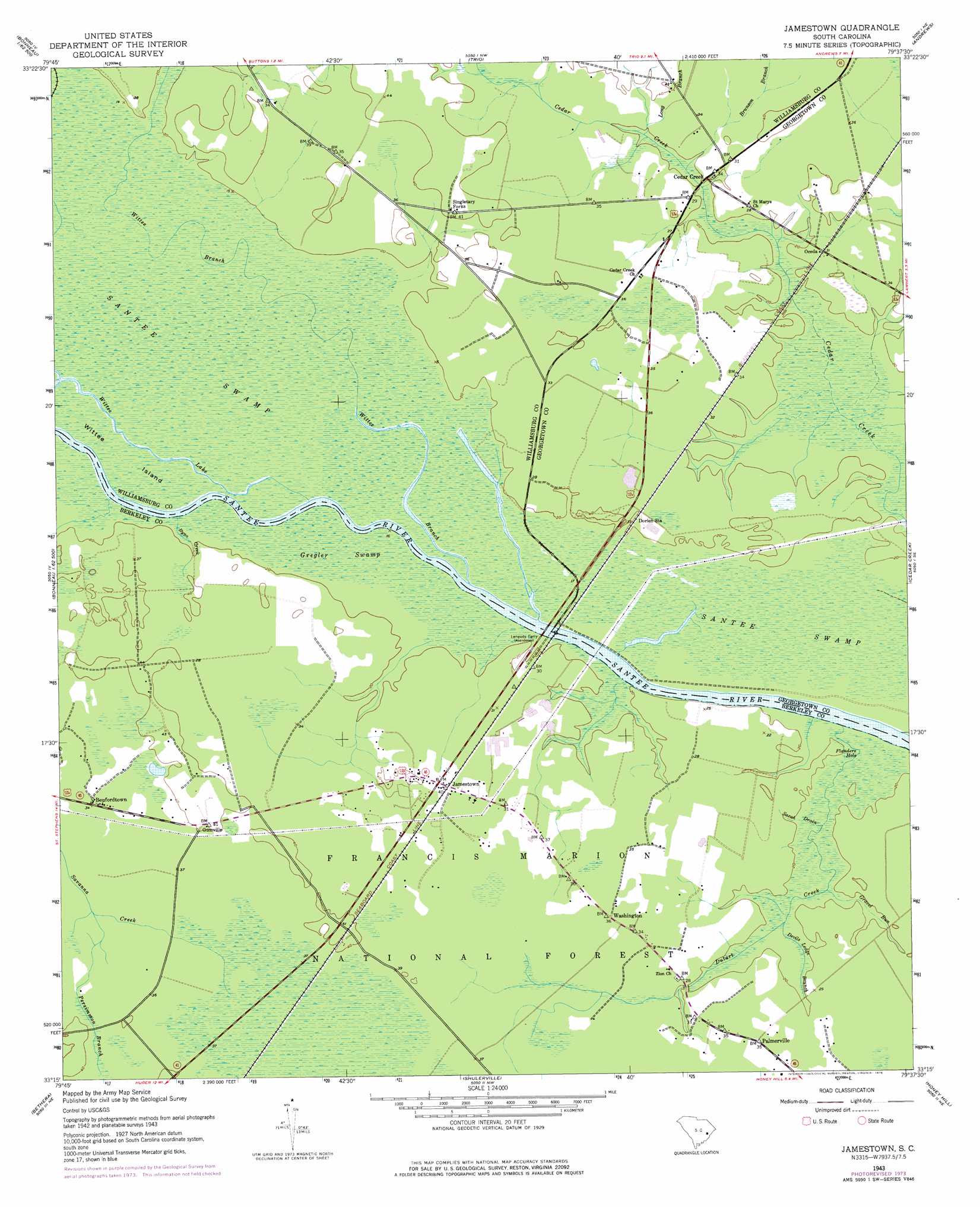
USGS Topo Quad 33079c6 - 1:24,000 scale
| Topo Map Name: | Jamestown |
| USGS Topo Quad ID: | 33079c6 |
| Print Size: | ca. 21 1/4" wide x 27" high |
| Southeast Coordinates: | 33.25° N latitude / 79.625° W longitude |
| Map Center Coordinates: | 33.3125° N latitude / 79.6875° W longitude |
| U.S. State: | SC |
| Filename: | o33079c6.jpg |
| Download Map JPG Image: | Jamestown topo map 1:24,000 scale |
| Map Type: | Topographic |
| Topo Series: | 7.5´ |
| Map Scale: | 1:24,000 |
| Source of Map Images: | United States Geological Survey (USGS) |
| Alternate Map Versions: |
Jamestown SC 1943, updated 1962 Download PDF Buy paper map Jamestown SC 1943, updated 1976 Download PDF Buy paper map Jamestown SC 2011 Download PDF Buy paper map Jamestown SC 2014 Download PDF Buy paper map |
| FStopo: | US Forest Service topo Jamestown is available: Download FStopo PDF Download FStopo TIF |
1:24,000 Topo Quads surrounding Jamestown
Greeleyville |
Salters |
Kellehan Crossroads |
Warsaw |
Rhems |
Saint Stephens |
Blakely |
Trio |
Andrews |
Olin |
Bonneau |
Wedboo Creek |
Jamestown |
Cedar Creek |
Kilsock Bay |
Cordesville |
Bethera |
Shulerville |
Honey Hill |
Santee |
Kittredge |
Huger |
Ocean Bay |
Awendaw |
Mcclellanville |
> Back to 33079a1 at 1:100,000 scale
> Back to 33078a1 at 1:250,000 scale
> Back to U.S. Topo Maps home
Jamestown topo map: Gazetteer
Jamestown: Bridges
Leneuds Ferry Bridge elevation 3m 9′Jamestown: Islands
Wittee Island elevation 3m 9′Jamestown: Lakes
Ferry Lake elevation 4m 13′Flanders Hole elevation 4m 13′
Wittee Lake elevation 3m 9′
Jamestown: Populated Places
Beufordtown elevation 9m 29′Cedar Creek elevation 6m 19′
Jamestown elevation 9m 29′
Oceda elevation 8m 26′
Palmerville elevation 9m 29′
Singletary Forks elevation 12m 39′
Tiger Corner (historical) elevation 9m 29′
Washington elevation 9m 29′
Jamestown: Post Offices
Jamestown Post Office elevation 10m 32′Jamestown: Streams
Brunson Branch elevation 5m 16′Byno Creek elevation 1m 3′
Devils Lodge Branch elevation 6m 19′
Dutart Creek elevation 4m 13′
Gravel Run elevation 6m 19′
Long Branch elevation 6m 19′
Persimmon Branch elevation 9m 29′
Sarah Drain elevation 5m 16′
Savanna Creek elevation 1m 3′
Wittee Branch elevation 1m 3′
Jamestown: Swamps
Gregler Swamp elevation 3m 9′Jamestown digital topo map on disk
Buy this Jamestown topo map showing relief, roads, GPS coordinates and other geographical features, as a high-resolution digital map file on DVD:
South Carolina, Western North Carolina & Northeastern Georgia
Buy digital topo maps: South Carolina, Western North Carolina & Northeastern Georgia