Saint Stephens Topo Map South Carolina
To zoom in, hover over the map of Saint Stephens
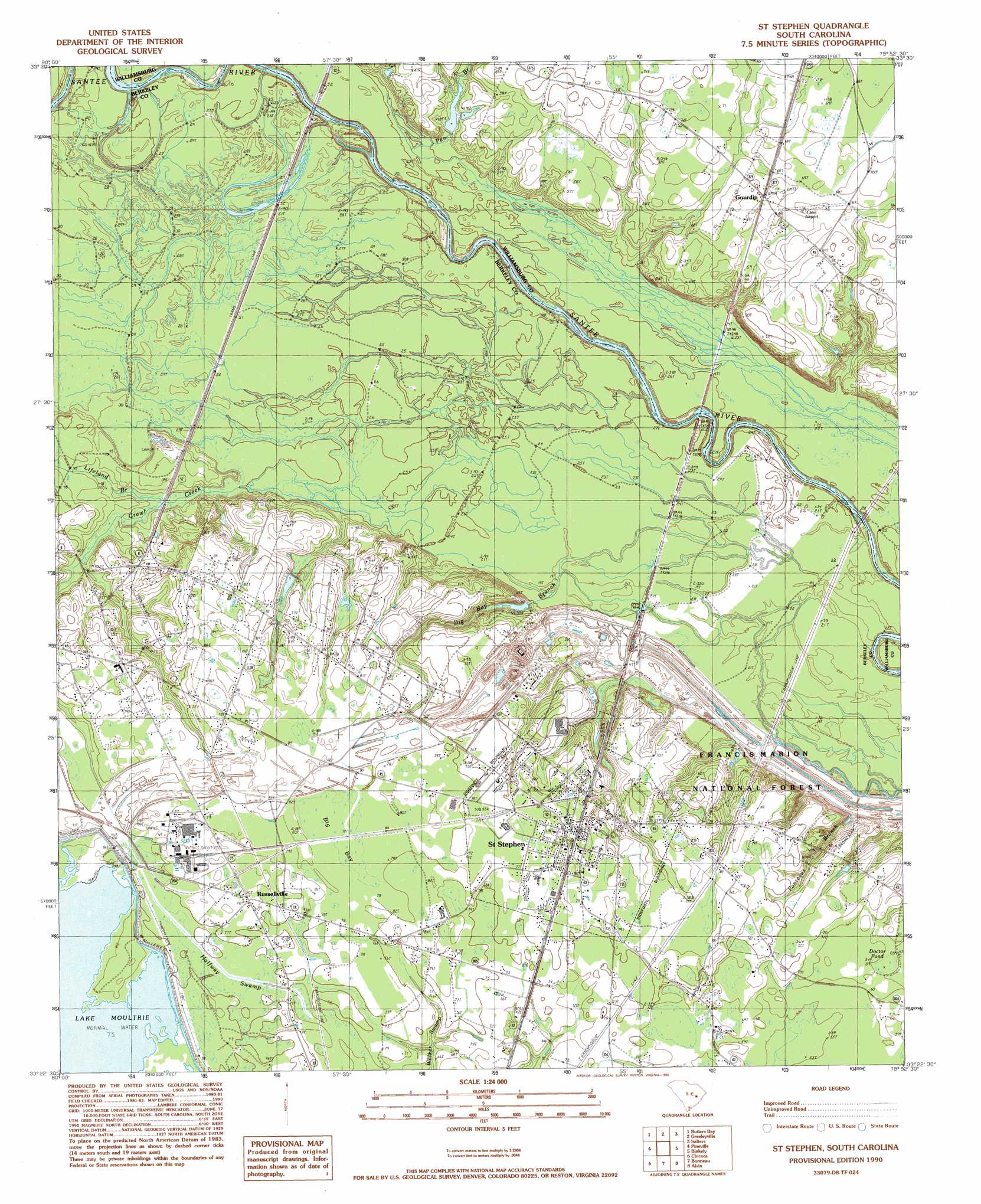
USGS Topo Quad 33079d8 - 1:24,000 scale
| Topo Map Name: | Saint Stephens |
| USGS Topo Quad ID: | 33079d8 |
| Print Size: | ca. 21 1/4" wide x 27" high |
| Southeast Coordinates: | 33.375° N latitude / 79.875° W longitude |
| Map Center Coordinates: | 33.4375° N latitude / 79.9375° W longitude |
| U.S. State: | SC |
| Filename: | o33079d8.jpg |
| Download Map JPG Image: | Saint Stephens topo map 1:24,000 scale |
| Map Type: | Topographic |
| Topo Series: | 7.5´ |
| Map Scale: | 1:24,000 |
| Source of Map Images: | United States Geological Survey (USGS) |
| Alternate Map Versions: |
St. Stephen SC 1990, updated 1990 Download PDF Buy paper map Saint Stephen SC 2011 Download PDF Buy paper map Saint Stephen SC 2014 Download PDF Buy paper map |
| FStopo: | US Forest Service topo Saint Stephen is available: Download FStopo PDF Download FStopo TIF |
1:24,000 Topo Quads surrounding Saint Stephens
Manning |
Foreston |
Workman |
Kingstree |
Fowler |
Jordan |
Butlers Bay |
Greeleyville |
Salters |
Kellehan Crossroads |
Eadytown |
Pineville |
Saint Stephens |
Blakely |
Trio |
Cross |
Chicora |
Bonneau |
Wedboo Creek |
Jamestown |
Summerville Nw |
Moncks Corner |
Cordesville |
Bethera |
Shulerville |
> Back to 33079a1 at 1:100,000 scale
> Back to 33078a1 at 1:250,000 scale
> Back to U.S. Topo Maps home
Saint Stephens topo map: Gazetteer
Saint Stephens: Airports
Lane Airport (historical) elevation 21m 68′Saint Stephens: Basins
Big Bay elevation 24m 78′Saint Stephens: Bridges
Murrays Ferry Bridge elevation 4m 13′Saint Stephens: Crossings
Murrays Ferry (historical) elevation 4m 13′Saint Stephens: Dams
J P Gamble Pond Dam elevation 8m 26′Saint Stephens: Populated Places
Gourdin elevation 22m 72′Harris Town elevation 19m 62′
North End (historical) elevation 7m 22′
Old Peru elevation 24m 78′
Russellville elevation 24m 78′
Saint Stephen elevation 24m 78′
Santee (historical) elevation 8m 26′
Swamp Fox elevation 15m 49′
Saint Stephens: Post Offices
Russellville Post Office elevation 24m 78′Saint Stephen Post Office elevation 24m 78′
Saint Stephens: Reservoirs
J P Gamble Pond elevation 8m 26′Saint Stephens: Streams
Big Bay Branch elevation 5m 16′Halfway Swamp elevation 19m 62′
Kelley Branch elevation 8m 26′
Lifeland Branch elevation 10m 32′
Penn Branch elevation 8m 26′
Ponteaux Branch elevation 6m 19′
Saint Stephens: Swamps
Doctor Pond elevation 18m 59′Saint Stephens digital topo map on disk
Buy this Saint Stephens topo map showing relief, roads, GPS coordinates and other geographical features, as a high-resolution digital map file on DVD:
South Carolina, Western North Carolina & Northeastern Georgia
Buy digital topo maps: South Carolina, Western North Carolina & Northeastern Georgia