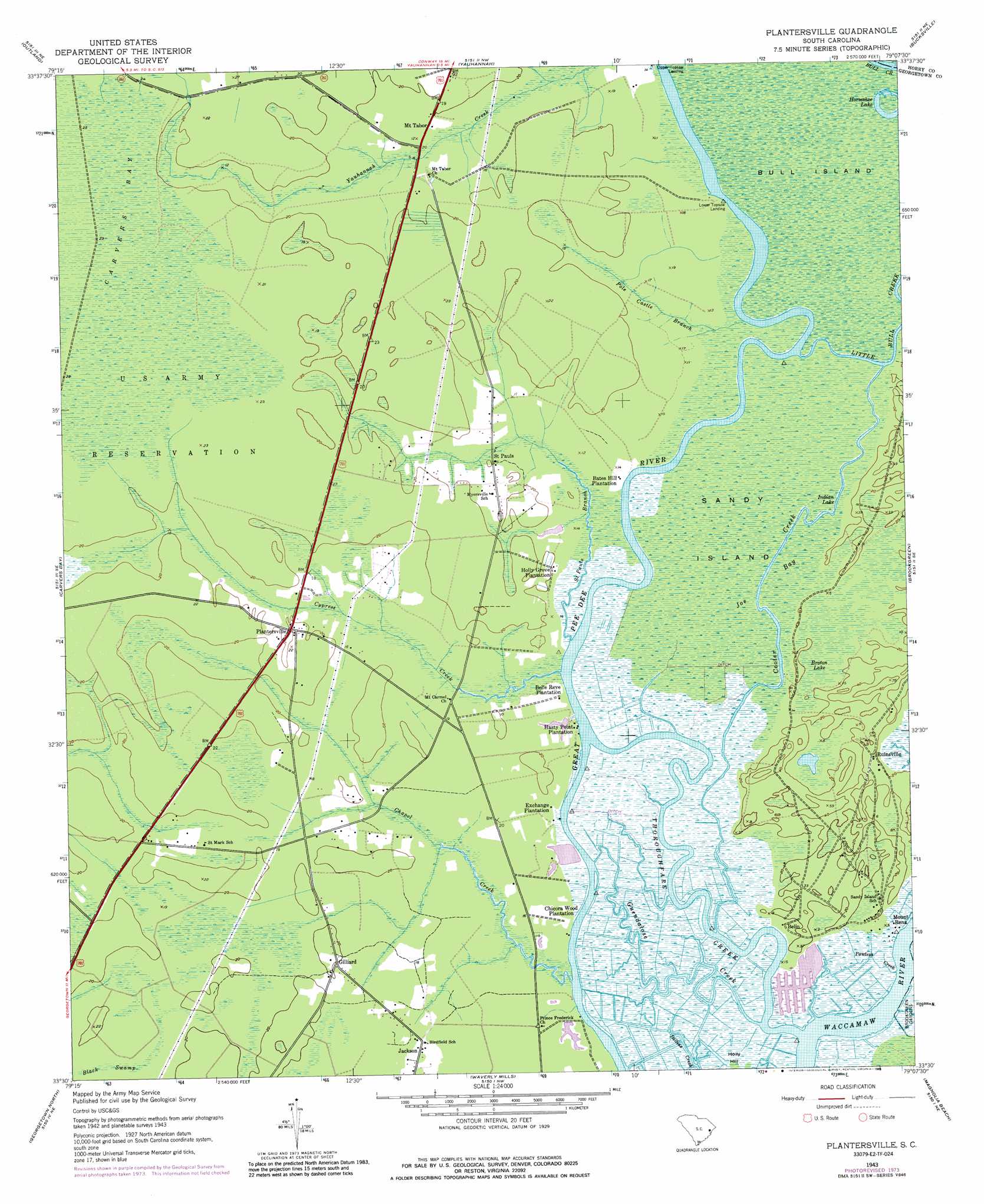
Plantersville Topo Map South Carolina
To zoom in, hover over the map of Plantersville
USGS Topo Quad 33079e2 - 1:24,000 scale
| Topo Map Name: | Plantersville |
| USGS Topo Quad ID: | 33079e2 |
| Print Size: | ca. 21 1/4" wide x 27" high |
| Southeast Coordinates: | 33.5° N latitude / 79.125° W longitude |
| Map Center Coordinates: | 33.5625° N latitude / 79.1875° W longitude |
| U.S. State: | SC |
| Filename: | o33079e2.jpg |
| Download Map JPG Image: | Plantersville topo map 1:24,000 scale |
| Map Type: | Topographic |
| Topo Series: | 7.5´ |
| Map Scale: | 1:24,000 |
| Source of Map Images: | United States Geological Survey (USGS) |
| Alternate Map Versions: |
Plantersville SC 1943, updated 1962 Download PDF Buy paper map Plantersville SC 1943, updated 1976 Download PDF Buy paper map Plantersville SC 1943, updated 1989 Download PDF Buy paper map Plantersville SC 2011 Download PDF Buy paper map Plantersville SC 2014 Download PDF Buy paper map |
1:24,000 Topo Quads surrounding Plantersville
Johnsonville |
Snow Island |
Dongola |
Conway |
Nixonville |
Henry |
Outland |
Yauhannah |
Bucksville |
Myrtle Beach |
Rhems |
Carvers Bay |
Plantersville |
Brookgreen |
Surfside Beach |
Olin |
Georgetown North |
Waverly Mills |
Magnolia Beach |
|
Kilsock Bay |
Georgetown South |
North Island |
> Back to 33079e1 at 1:100,000 scale
> Back to 33078a1 at 1:250,000 scale
> Back to U.S. Topo Maps home
Plantersville topo map: Gazetteer
Plantersville: Islands
Bull Island elevation 1m 3′Sandy Island elevation 1m 3′
Plantersville: Lakes
Horseshoe Lake elevation 1m 3′Indian Lake elevation 1m 3′
Plantersville: Populated Places
Belin elevation 5m 16′Gilliard elevation 6m 19′
Lower Topsaw Landing elevation 1m 3′
Mount Rena elevation 5m 16′
Mount Tabor elevation 5m 16′
Plantersville elevation 6m 19′
Saint Pauls elevation 3m 9′
Upper Topsaw Landing elevation 1m 3′
Plantersville: Streams
Chapel Creek elevation 0m 0′Cooter Creek elevation 1m 3′
Cypress Creek elevation 1m 3′
Guendalose Creek elevation 0m 0′
Pawleys Creek elevation 0m 0′
Pole Castle Branch elevation 1m 3′
Saint Pauls Branch elevation 1m 3′
Thoroughfare Creek elevation 0m 0′
Plantersville: Swamps
Broton Lake elevation 1m 3′Joe Bay elevation 1m 3′
Plantersville digital topo map on disk
Buy this Plantersville topo map showing relief, roads, GPS coordinates and other geographical features, as a high-resolution digital map file on DVD:
South Carolina, Western North Carolina & Northeastern Georgia
Buy digital topo maps: South Carolina, Western North Carolina & Northeastern Georgia