Prospect Crossroads Topo Map South Carolina
To zoom in, hover over the map of Prospect Crossroads
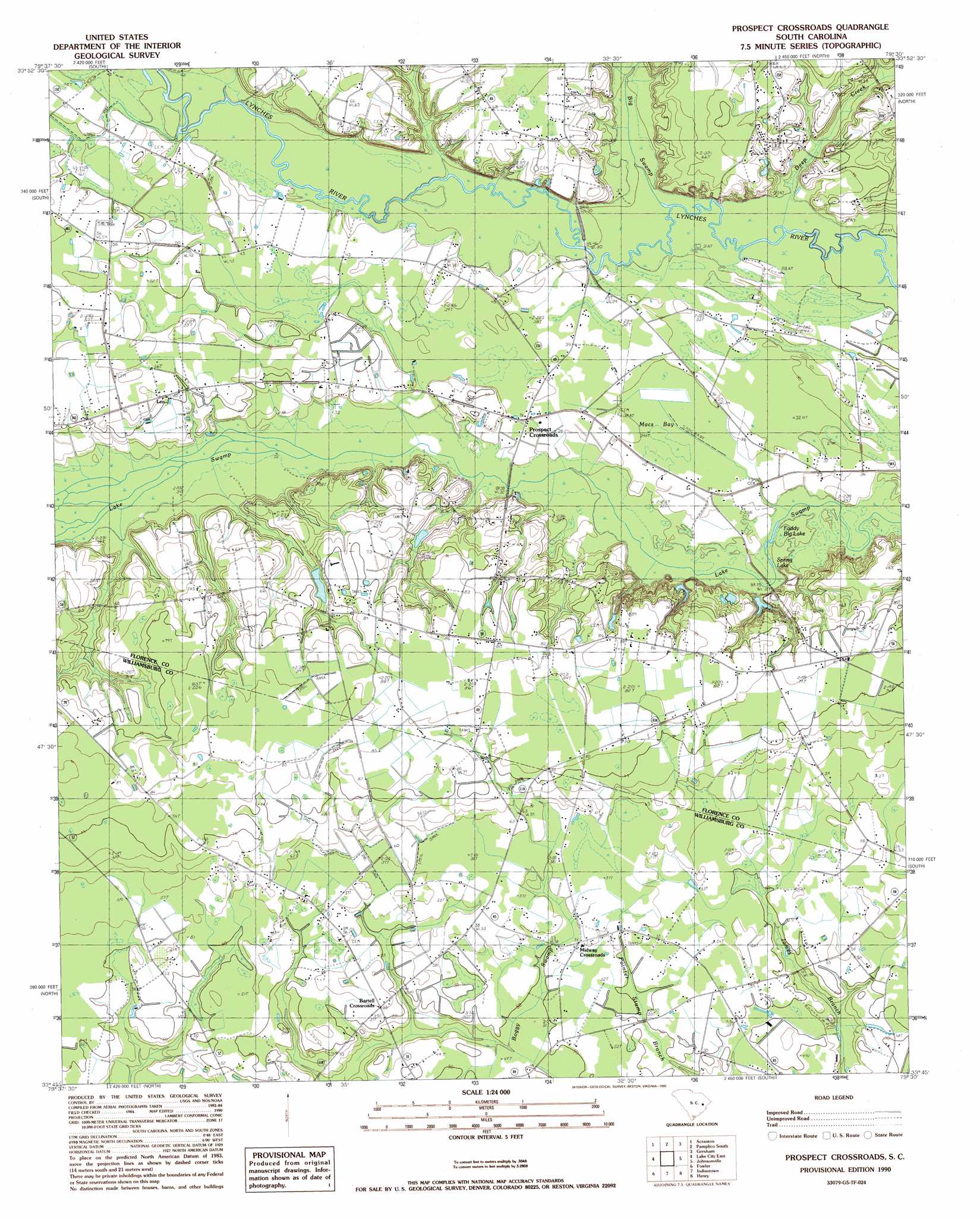
USGS Topo Quad 33079g5 - 1:24,000 scale
| Topo Map Name: | Prospect Crossroads |
| USGS Topo Quad ID: | 33079g5 |
| Print Size: | ca. 21 1/4" wide x 27" high |
| Southeast Coordinates: | 33.75° N latitude / 79.5° W longitude |
| Map Center Coordinates: | 33.8125° N latitude / 79.5625° W longitude |
| U.S. State: | SC |
| Filename: | o33079g5.jpg |
| Download Map JPG Image: | Prospect Crossroads topo map 1:24,000 scale |
| Map Type: | Topographic |
| Topo Series: | 7.5´ |
| Map Scale: | 1:24,000 |
| Source of Map Images: | United States Geological Survey (USGS) |
| Alternate Map Versions: |
Prospect Crossroads SC 1990, updated 1990 Download PDF Buy paper map Prospect Crossroads SC 2011 Download PDF Buy paper map Prospect Crossroads SC 2014 Download PDF Buy paper map |
1:24,000 Topo Quads surrounding Prospect Crossroads
Effingham |
Evergreen |
Pamplico North |
Friendship |
Centenary |
Mill Bay |
Scranton |
Pamplico South |
Gresham |
Britton Neck |
Lake City West |
Lake City East |
Prospect Crossroads |
Johnsonville |
Snow Island |
Kingstree |
Fowler |
Indiantown |
Henry |
Outland |
Salters |
Kellehan Crossroads |
Warsaw |
Rhems |
Carvers Bay |
> Back to 33079e1 at 1:100,000 scale
> Back to 33078a1 at 1:250,000 scale
> Back to U.S. Topo Maps home
Prospect Crossroads topo map: Gazetteer
Prospect Crossroads: Basins
Macs Bay elevation 10m 32′Prospect Crossroads: Dams
Leo Hanna Pond Dam D-3567 elevation 23m 75′Prospect Crossroads: Lakes
Bens Lake elevation 8m 26′Eaddy Big Lake elevation 8m 26′
Raccoon Lake elevation 9m 29′
Spring Lake elevation 9m 29′
Prospect Crossroads: Populated Places
Bartell Crossroads elevation 16m 52′Half Moon (historical) elevation 10m 32′
Leo elevation 18m 59′
Midway Crossroads elevation 16m 52′
Prospect Crossroads elevation 12m 39′
Prospect Crossroads: Reservoirs
Leo Hanna Pond elevation 23m 75′Prospect Crossroads: Streams
Big Swamp Branch elevation 9m 29′Deep Creek elevation 9m 29′
Gum Branch elevation 10m 32′
Prospect Crossroads digital topo map on disk
Buy this Prospect Crossroads topo map showing relief, roads, GPS coordinates and other geographical features, as a high-resolution digital map file on DVD:
South Carolina, Western North Carolina & Northeastern Georgia
Buy digital topo maps: South Carolina, Western North Carolina & Northeastern Georgia