Horry Topo Map South Carolina
To zoom in, hover over the map of Horry
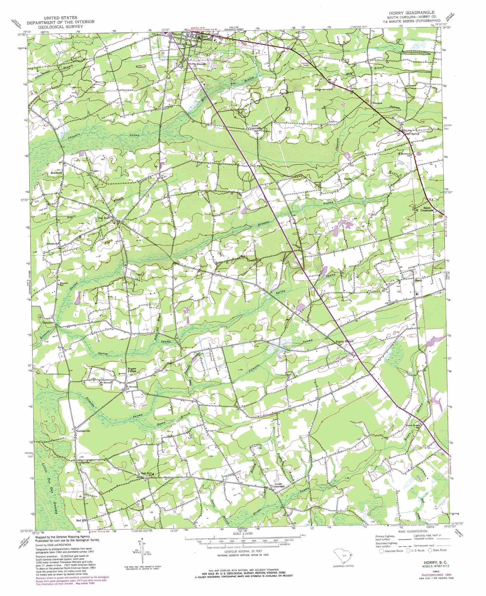
USGS Topo Quad 33079h2 - 1:24,000 scale
| Topo Map Name: | Horry |
| USGS Topo Quad ID: | 33079h2 |
| Print Size: | ca. 21 1/4" wide x 27" high |
| Southeast Coordinates: | 33.875° N latitude / 79.125° W longitude |
| Map Center Coordinates: | 33.9375° N latitude / 79.1875° W longitude |
| U.S. State: | SC |
| Filename: | o33079h2.jpg |
| Download Map JPG Image: | Horry topo map 1:24,000 scale |
| Map Type: | Topographic |
| Topo Series: | 7.5´ |
| Map Scale: | 1:24,000 |
| Source of Map Images: | United States Geological Survey (USGS) |
| Alternate Map Versions: |
Horry SC 1943, updated 1962 Download PDF Buy paper map Horry SC 1943, updated 1980 Download PDF Buy paper map Horry SC 2011 Download PDF Buy paper map Horry SC 2014 Download PDF Buy paper map |
1:24,000 Topo Quads surrounding Horry
Marion |
Mullins |
Nichols |
Duford |
Tabor City West |
Friendship |
Centenary |
Galivants Ferry |
Bayboro |
Loris |
Gresham |
Britton Neck |
Horry |
Adrian |
Shell |
Johnsonville |
Snow Island |
Dongola |
Conway |
Nixonville |
Henry |
Outland |
Yauhannah |
Bucksville |
Myrtle Beach |
> Back to 33079e1 at 1:100,000 scale
> Back to 33078a1 at 1:250,000 scale
> Back to U.S. Topo Maps home
Horry topo map: Gazetteer
Horry: Dams
Smith Pond Dam D-3621 elevation 20m 65′South Carolina Noname I6039 Dam elevation 19m 62′
Horry: Populated Places
Aynor elevation 31m 101′Chinners elevation 20m 65′
Cool Spring elevation 28m 91′
Dog Bluff elevation 25m 82′
Doyle elevation 23m 75′
Gideon elevation 20m 65′
Horry elevation 25m 82′
Jones Crossroads elevation 21m 68′
Jonestown elevation 19m 62′
Jordanville elevation 8m 26′
Knotty Branch elevation 23m 75′
Lundy Crossroads elevation 12m 39′
Pleasant Hill elevation 19m 62′
Rehobeth elevation 15m 49′
Salem Crossroads elevation 25m 82′
Tompkins elevation 7m 22′
Horry: Post Offices
Aynor Post Office elevation 26m 85′Horry: Reservoirs
Smith Pond elevation 20m 65′Horry: Streams
Cooper Branch elevation 11m 36′Holly Hill Branch elevation 11m 36′
Knotty Branch elevation 11m 36′
Little Palmetto Swamp elevation 11m 36′
Mill Branch elevation 12m 39′
Ratan Branch elevation 11m 36′
Spring Swamp elevation 6m 19′
Horry digital topo map on disk
Buy this Horry topo map showing relief, roads, GPS coordinates and other geographical features, as a high-resolution digital map file on DVD:
South Carolina, Western North Carolina & Northeastern Georgia
Buy digital topo maps: South Carolina, Western North Carolina & Northeastern Georgia