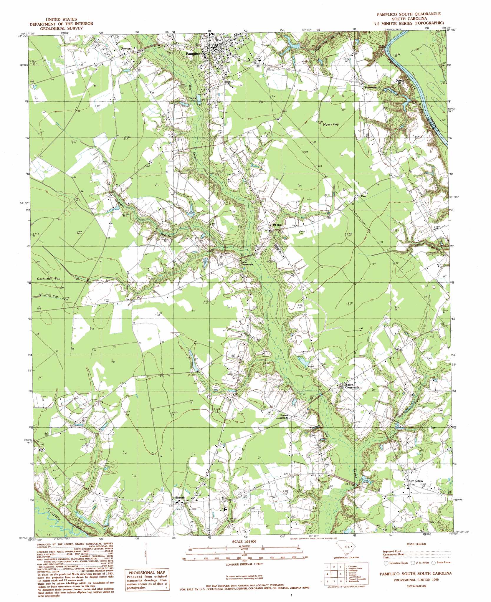
Pamplico South Topo Map South Carolina
To zoom in, hover over the map of Pamplico South
USGS Topo Quad 33079h5 - 1:24,000 scale
| Topo Map Name: | Pamplico South |
| USGS Topo Quad ID: | 33079h5 |
| Print Size: | ca. 21 1/4" wide x 27" high |
| Southeast Coordinates: | 33.875° N latitude / 79.5° W longitude |
| Map Center Coordinates: | 33.9375° N latitude / 79.5625° W longitude |
| U.S. State: | SC |
| Filename: | o33079h5.jpg |
| Download Map JPG Image: | Pamplico South topo map 1:24,000 scale |
| Map Type: | Topographic |
| Topo Series: | 7.5´ |
| Map Scale: | 1:24,000 |
| Source of Map Images: | United States Geological Survey (USGS) |
| Alternate Map Versions: |
Pamplico South SC 1990, updated 1990 Download PDF Buy paper map Pamplico South SC 2011 Download PDF Buy paper map Pamplico South SC 2014 Download PDF Buy paper map |
1:24,000 Topo Quads surrounding Pamplico South
Florence West |
Florence East |
Pee Dee |
Marion |
Mullins |
Effingham |
Evergreen |
Pamplico North |
Friendship |
Centenary |
Mill Bay |
Scranton |
Pamplico South |
Gresham |
Britton Neck |
Lake City West |
Lake City East |
Prospect Crossroads |
Johnsonville |
Snow Island |
Kingstree |
Fowler |
Indiantown |
Henry |
Outland |
> Back to 33079e1 at 1:100,000 scale
> Back to 33078a1 at 1:250,000 scale
> Back to U.S. Topo Maps home
Pamplico South topo map: Gazetteer
Pamplico South: Basins
Cockfield Bay elevation 25m 82′Myers Bay elevation 25m 82′
Pamplico South: Cliffs
DeWitt Bluff elevation 19m 62′Pamplico South: Dams
Coleman Pond Dam D-3579 elevation 23m 75′Floyd Pond Dam D-3583 elevation 16m 52′
J G Holliday Pond Dam D-3581 elevation 20m 65′
J H Holliday Pond Dam D-3584 elevation 15m 49′
Miller Pond Dam D-3582 elevation 14m 45′
Richard Holliday Lower Dam D-3577 elevation 14m 45′
Richard Holliday Pond Dam D-3576 elevation 18m 59′
Pamplico South: Populated Places
Bazen Crossroads elevation 20m 65′Blossom elevation 19m 62′
Butler Crossroads elevation 20m 65′
Evans Crossroads elevation 23m 75′
Fleet elevation 24m 78′
Flemingtown elevation 22m 72′
Hannah elevation 18m 59′
Hyman elevation 25m 82′
Mount Zion elevation 23m 75′
Pamplico elevation 25m 82′
Poston Crossroads elevation 20m 65′
Salem elevation 22m 72′
Pamplico South: Post Offices
Pamplico Post Office elevation 26m 85′Pamplico South: Reservoirs
Coleman Pond Dam elevation 23m 75′Floyd Pond elevation 16m 52′
J G Holliday Pond elevation 20m 65′
J H Holliday Pond elevation 15m 49′
Miller Pond elevation 14m 45′
Richard Holliday Lower Pond elevation 14m 45′
Richard Holliday Pond elevation 18m 59′
Pamplico South: Streams
Barfield Mill Creek elevation 6m 19′Bay Branch elevation 14m 45′
Cypress Branch elevation 14m 45′
Little Swamp elevation 11m 36′
Pamplico South digital topo map on disk
Buy this Pamplico South topo map showing relief, roads, GPS coordinates and other geographical features, as a high-resolution digital map file on DVD:
South Carolina, Western North Carolina & Northeastern Georgia
Buy digital topo maps: South Carolina, Western North Carolina & Northeastern Georgia