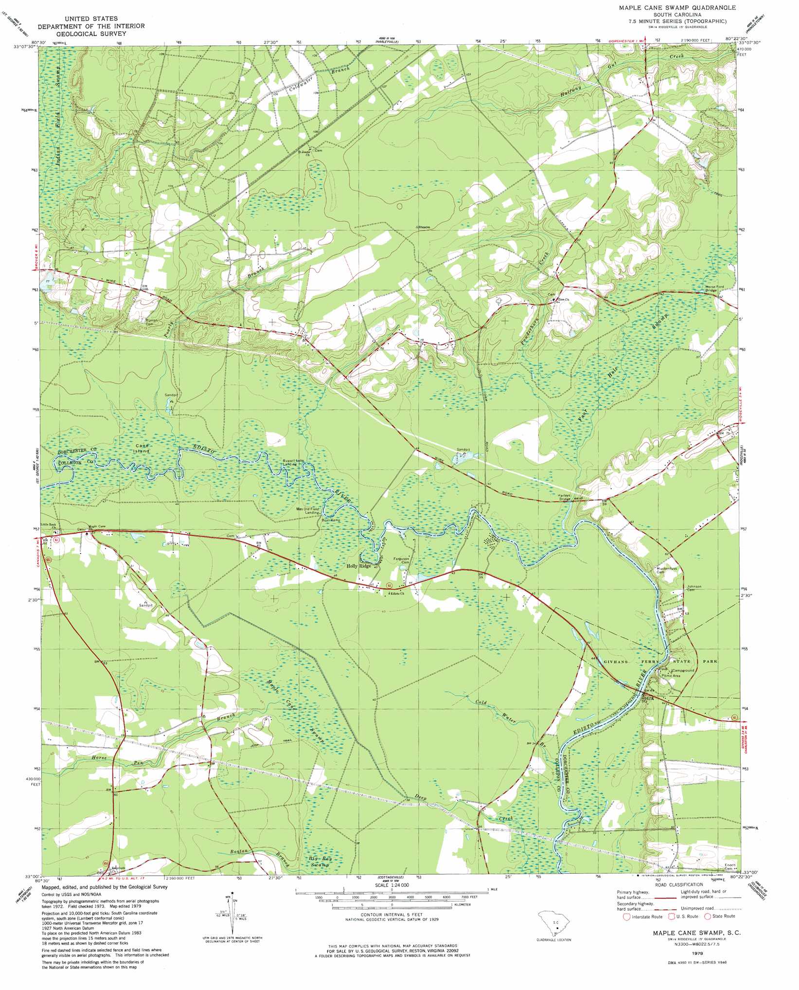
Maple Cane Swamp Topo Map South Carolina
To zoom in, hover over the map of Maple Cane Swamp
USGS Topo Quad 33080a4 - 1:24,000 scale
| Topo Map Name: | Maple Cane Swamp |
| USGS Topo Quad ID: | 33080a4 |
| Print Size: | ca. 21 1/4" wide x 27" high |
| Southeast Coordinates: | 33° N latitude / 80.375° W longitude |
| Map Center Coordinates: | 33.0625° N latitude / 80.4375° W longitude |
| U.S. State: | SC |
| Filename: | o33080a4.jpg |
| Download Map JPG Image: | Maple Cane Swamp topo map 1:24,000 scale |
| Map Type: | Topographic |
| Topo Series: | 7.5´ |
| Map Scale: | 1:24,000 |
| Source of Map Images: | United States Geological Survey (USGS) |
| Alternate Map Versions: |
Maple Cane Swamp SC 1979, updated 1980 Download PDF Buy paper map Maple Cane Swamp SC 2011 Download PDF Buy paper map Maple Cane Swamp SC 2014 Download PDF Buy paper map |
1:24,000 Topo Quads surrounding Maple Cane Swamp
Bowman |
Wadboo Swamp |
Holly Hill |
Sandridge |
Cross |
Reevesville |
Saint George |
Harleyville |
Pringletown |
Summerville Nw |
Saint George Sw |
Canadys |
Maple Cane Swamp |
Ridgeville |
Summerville |
Walterboro |
Round O |
Cottageville |
Clubhouse Crossroads |
Stallsville |
Hendersonville |
Neyles |
Jacksonboro |
Osborn |
Ravenel |
> Back to 33080a1 at 1:100,000 scale
> Back to 33080a1 at 1:250,000 scale
> Back to U.S. Topo Maps home
Maple Cane Swamp topo map: Gazetteer
Maple Cane Swamp: Bridges
Givhans Bridge elevation 9m 29′Harleys Bridge elevation 11m 36′
Horse Ford Bridge elevation 12m 39′
Maple Cane Swamp: Crossings
Givhan Ferry (historical) elevation 9m 29′Maple Cane Swamp: Dams
Rumphs Pond Dam D-2549 elevation 27m 88′Maple Cane Swamp: Islands
Cane Island elevation 12m 39′Maple Cane Swamp: Parks
Givhans Ferry State Park elevation 17m 55′Maple Cane Swamp: Populated Places
Holly Ridge elevation 12m 39′Mas Old Field Landing elevation 12m 39′
Russell Lake Landing elevation 11m 36′
Maple Cane Swamp: Reservoirs
Rumphs Pond elevation 27m 88′Maple Cane Swamp: Streams
Boston Branch elevation 12m 39′Cold Water Branch elevation 9m 29′
Four Hole Swamp elevation 10m 32′
Horse Pen Branch elevation 13m 42′
Poorly Branch elevation 29m 95′
Powderhorn Creek elevation 10m 32′
Maple Cane Swamp: Swamps
Maple Cane Swamp elevation 13m 42′Maple Cane Swamp digital topo map on disk
Buy this Maple Cane Swamp topo map showing relief, roads, GPS coordinates and other geographical features, as a high-resolution digital map file on DVD:
South Carolina, Western North Carolina & Northeastern Georgia
Buy digital topo maps: South Carolina, Western North Carolina & Northeastern Georgia