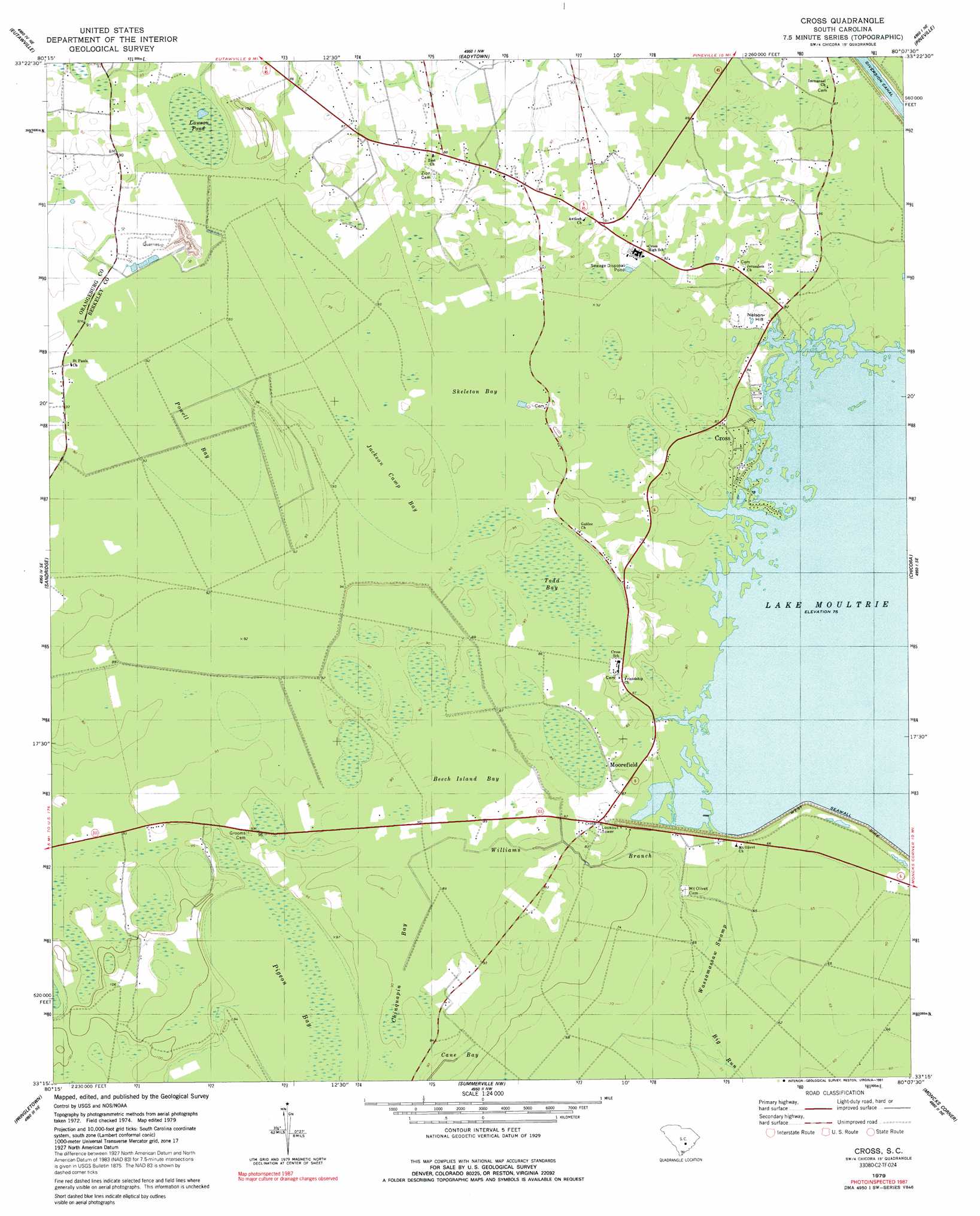
Cross Topo Map South Carolina
To zoom in, hover over the map of Cross
USGS Topo Quad 33080c2 - 1:24,000 scale
| Topo Map Name: | Cross |
| USGS Topo Quad ID: | 33080c2 |
| Print Size: | ca. 21 1/4" wide x 27" high |
| Southeast Coordinates: | 33.25° N latitude / 80.125° W longitude |
| Map Center Coordinates: | 33.3125° N latitude / 80.1875° W longitude |
| U.S. State: | SC |
| Filename: | o33080c2.jpg |
| Download Map JPG Image: | Cross topo map 1:24,000 scale |
| Map Type: | Topographic |
| Topo Series: | 7.5´ |
| Map Scale: | 1:24,000 |
| Source of Map Images: | United States Geological Survey (USGS) |
| Alternate Map Versions: |
Cross SC 1979, updated 1980 Download PDF Buy paper map Cross SC 1979, updated 1991 Download PDF Buy paper map Cross SC 2011 Download PDF Buy paper map Cross SC 2014 Download PDF Buy paper map |
1:24,000 Topo Quads surrounding Cross
Saint Paul |
Summerton |
Jordan |
Butlers Bay |
Greeleyville |
Vance |
Eutawville |
Eadytown |
Pineville |
Saint Stephens |
Holly Hill |
Sandridge |
Cross |
Chicora |
Bonneau |
Harleyville |
Pringletown |
Summerville Nw |
Moncks Corner |
Cordesville |
Maple Cane Swamp |
Ridgeville |
Summerville |
Mount Holly |
Kittredge |
> Back to 33080a1 at 1:100,000 scale
> Back to 33080a1 at 1:250,000 scale
> Back to U.S. Topo Maps home
Cross topo map: Gazetteer
Cross: Basins
Beech Island Bay elevation 26m 85′Cane Bay elevation 24m 78′
Powell Bay elevation 27m 88′
Cross: Lakes
Lawson Pond elevation 27m 88′Cross: Mines
Berkeley Quarry elevation 27m 88′Cross: Populated Places
Cross elevation 24m 78′Cross Cross Roads elevation 25m 82′
Legare (historical) elevation 28m 91′
Moorefield elevation 26m 85′
Moss Grove elevation 29m 95′
Mudville (historical) elevation 30m 98′
Nelson Hill elevation 27m 88′
Pigeon Bay (historical) elevation 31m 101′
Prioleau elevation 27m 88′
Cross: Post Offices
Cross Post Office elevation 26m 85′Cross: Ridges
Layton Ridge elevation 28m 91′Cross: Streams
Williams Branch elevation 17m 55′Cross: Summits
Nelson Hill elevation 26m 85′Cross: Swamps
Buzzard Bay elevation 27m 88′Chinquapin Bay elevation 27m 88′
Jackson Camp Bay elevation 28m 91′
Negro Bay elevation 28m 91′
Pigeon Bay elevation 27m 88′
Todd Bay elevation 27m 88′
Ward Swamp (historical) elevation 23m 75′
Wassamassaw Swamp elevation 18m 59′
Cross digital topo map on disk
Buy this Cross topo map showing relief, roads, GPS coordinates and other geographical features, as a high-resolution digital map file on DVD:
South Carolina, Western North Carolina & Northeastern Georgia
Buy digital topo maps: South Carolina, Western North Carolina & Northeastern Georgia