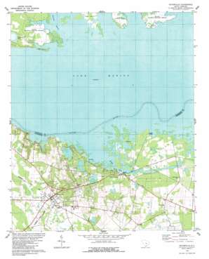
Eutawville Topo Map South Carolina
To zoom in, hover over the map of Eutawville
USGS Topo Quad 33080d3 - 1:24,000 scale
| Topo Map Name: | Eutawville |
| USGS Topo Quad ID: | 33080d3 |
| Print Size: | ca. 21 1/4" wide x 27" high |
| Southeast Coordinates: | 33.375° N latitude / 80.25° W longitude |
| Map Center Coordinates: | 33.4375° N latitude / 80.3125° W longitude |
| U.S. State: | SC |
| Filename: | o33080d3.jpg |
| Download Map JPG Image: | Eutawville topo map 1:24,000 scale |
| Map Type: | Topographic |
| Topo Series: | 7.5´ |
| Map Scale: | 1:24,000 |
| Source of Map Images: | United States Geological Survey (USGS) |
| Alternate Map Versions: |
Eutawville SC 1979, updated 1979 Download PDF Buy paper map Eutawville SC 2011 Download PDF Buy paper map Eutawville SC 2014 Download PDF Buy paper map |
1:24,000 Topo Quads surrounding Eutawville
> Back to 33080a1 at 1:100,000 scale
> Back to 33080a1 at 1:250,000 scale
> Back to U.S. Topo Maps home
Eutawville topo map: Gazetteer
Eutawville: Crossings
Nelsons Ferry (historical) elevation 23m 75′Eutawville: Islands
Pine Island elevation 24m 78′Round Island elevation 24m 78′
Eutawville: Lakes
Colclough Pond elevation 25m 82′Cuddo Lake (historical) elevation 23m 75′
Sullivan Lake (historical) elevation 23m 75′
Eutawville: Parks
Santee National Wildlife Refuge elevation 24m 78′Eutawville: Populated Places
Dorchee (historical) elevation 24m 78′Eutaw Springs elevation 26m 85′
Eutawville elevation 33m 108′
Ferguson (historical) elevation 23m 75′
Ferguson Landing elevation 23m 75′
Fountain Lake elevation 26m 85′
Green Town elevation 35m 114′
Little Belvidere elevation 32m 104′
Possum Town elevation 35m 114′
Saint Julian elevation 36m 118′
Eutawville: Post Offices
Eutawville Post Office elevation 34m 111′Eutawville: Streams
Eutaw Creek elevation 23m 75′Savanna Branch elevation 23m 75′
Tancaw Creek elevation 23m 75′
Tawcaw Creek elevation 23m 75′
Eutawville digital topo map on disk
Buy this Eutawville topo map showing relief, roads, GPS coordinates and other geographical features, as a high-resolution digital map file on DVD:
South Carolina, Western North Carolina & Northeastern Georgia
Buy digital topo maps: South Carolina, Western North Carolina & Northeastern Georgia


