Felderville Topo Map South Carolina
To zoom in, hover over the map of Felderville
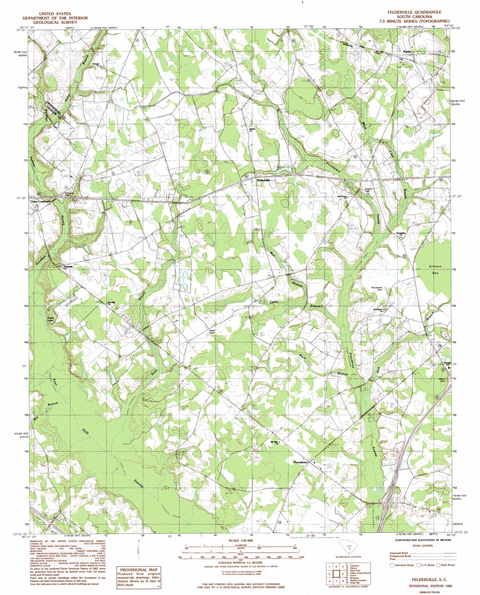
USGS Topo Quad 33080d5 - 1:24,000 scale
| Topo Map Name: | Felderville |
| USGS Topo Quad ID: | 33080d5 |
| Print Size: | ca. 21 1/4" wide x 27" high |
| Southeast Coordinates: | 33.375° N latitude / 80.5° W longitude |
| Map Center Coordinates: | 33.4375° N latitude / 80.5625° W longitude |
| U.S. State: | SC |
| Filename: | o33080d5.jpg |
| Download Map JPG Image: | Felderville topo map 1:24,000 scale |
| Map Type: | Topographic |
| Topo Series: | 7.5´ |
| Map Scale: | 1:24,000 |
| Source of Map Images: | United States Geological Survey (USGS) |
| Alternate Map Versions: |
Felderville SC 1982, updated 1983 Download PDF Buy paper map Felderville SC 2011 Download PDF Buy paper map Felderville SC 2014 Download PDF Buy paper map |
1:24,000 Topo Quads surrounding Felderville
Saint Mathews |
Fort Motte |
Lone Star |
Pinewood |
Paxville |
Orangeburg North |
Cameron |
Elloree |
Saint Paul |
Summerton |
Orangeburg South |
Indian Camp Branch |
Felderville |
Vance |
Eutawville |
Branchville North |
Bowman |
Wadboo Swamp |
Holly Hill |
Sandridge |
Branchville South |
Reevesville |
Saint George |
Harleyville |
Pringletown |
> Back to 33080a1 at 1:100,000 scale
> Back to 33080a1 at 1:250,000 scale
> Back to U.S. Topo Maps home
Felderville topo map: Gazetteer
Felderville: Crossings
Interchange 90 elevation 33m 108′Felderville: Dams
Bulls Pond Dam D-3774 elevation 44m 144′South Carolina Noname 38030 D-3761 Dam elevation 41m 134′
Felderville: Populated Places
Dantzler elevation 37m 121′Felderville elevation 45m 147′
Oaks Crossroads elevation 45m 147′
Parler elevation 46m 150′
Providence elevation 34m 111′
Felderville: Streams
Ball Branch elevation 36m 118′Ball Branch elevation 34m 111′
Bush Branch elevation 31m 101′
Candy Branch elevation 32m 104′
Canty Branch elevation 32m 104′
Goodbys Swamp elevation 40m 131′
Jack Branch elevation 29m 95′
Keller Branch elevation 38m 124′
Mill Branch elevation 32m 104′
White Cane Branch elevation 34m 111′
Felderville digital topo map on disk
Buy this Felderville topo map showing relief, roads, GPS coordinates and other geographical features, as a high-resolution digital map file on DVD:
South Carolina, Western North Carolina & Northeastern Georgia
Buy digital topo maps: South Carolina, Western North Carolina & Northeastern Georgia