Orangeburg South Topo Map South Carolina
To zoom in, hover over the map of Orangeburg South
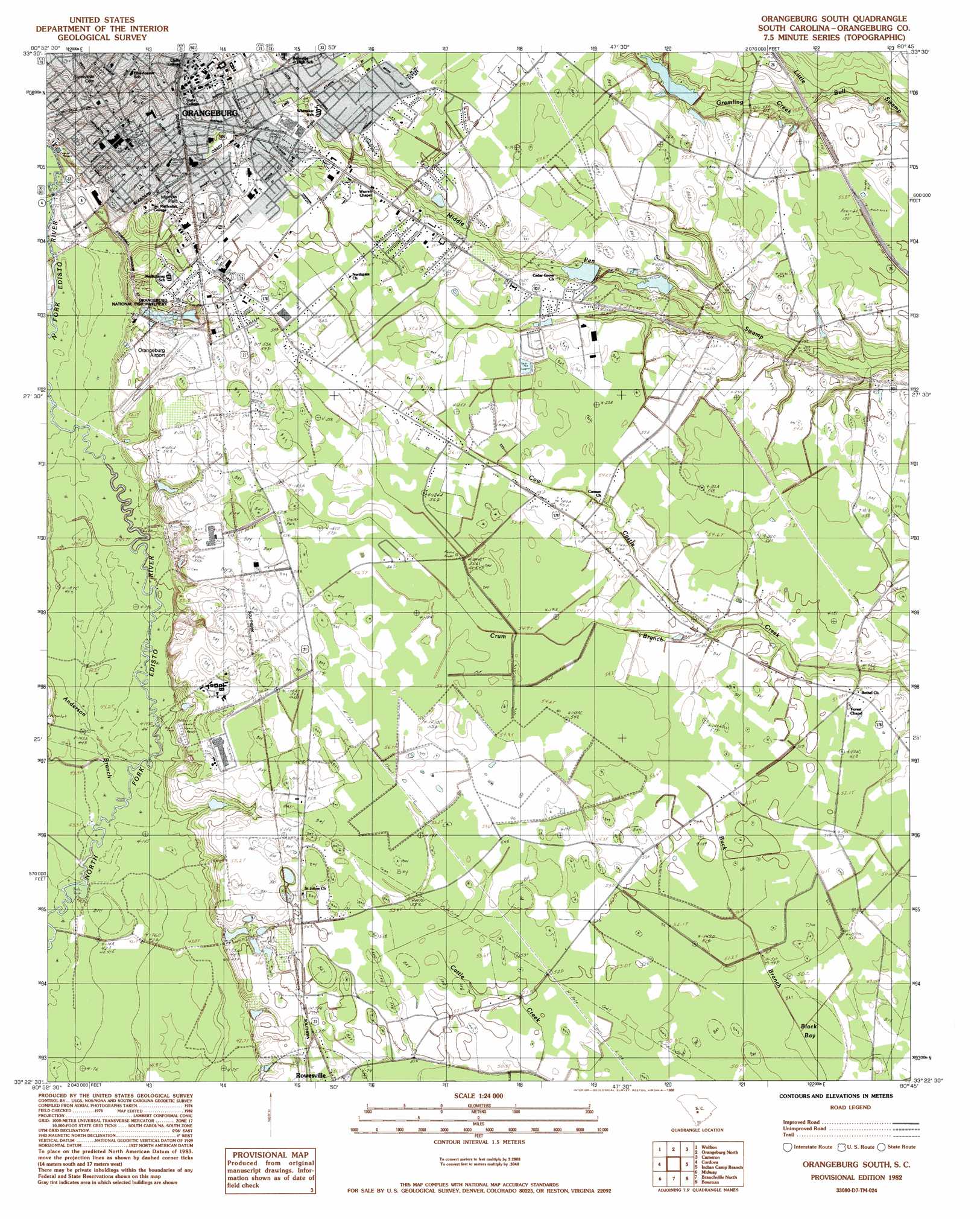
USGS Topo Quad 33080d7 - 1:24,000 scale
| Topo Map Name: | Orangeburg South |
| USGS Topo Quad ID: | 33080d7 |
| Print Size: | ca. 21 1/4" wide x 27" high |
| Southeast Coordinates: | 33.375° N latitude / 80.75° W longitude |
| Map Center Coordinates: | 33.4375° N latitude / 80.8125° W longitude |
| U.S. State: | SC |
| Filename: | o33080d7.jpg |
| Download Map JPG Image: | Orangeburg South topo map 1:24,000 scale |
| Map Type: | Topographic |
| Topo Series: | 7.5´ |
| Map Scale: | 1:24,000 |
| Source of Map Images: | United States Geological Survey (USGS) |
| Alternate Map Versions: |
Orangeburg South SC 1982, updated 1982 Download PDF Buy paper map Orangeburg South SC 1982, updated 1988 Download PDF Buy paper map Orangeburg South SC 2011 Download PDF Buy paper map Orangeburg South SC 2014 Download PDF Buy paper map |
1:24,000 Topo Quads surrounding Orangeburg South
Swansea |
Staley Crossroads |
Saint Mathews |
Fort Motte |
Lone Star |
North |
Wolfton |
Orangeburg North |
Cameron |
Elloree |
Norway East |
Cordova |
Orangeburg South |
Indian Camp Branch |
Felderville |
Bamberg |
Midway |
Branchville North |
Bowman |
Wadboo Swamp |
Clear Pond |
Tony Hill Bay |
Branchville South |
Reevesville |
Saint George |
> Back to 33080a1 at 1:100,000 scale
> Back to 33080a1 at 1:250,000 scale
> Back to U.S. Topo Maps home
Orangeburg South topo map: Gazetteer
Orangeburg South: Airports
Orangeburg Municipal Airport elevation 57m 187′Orangeburg South: Dams
South Carolina Noname 38001 D-3741 Dam elevation 50m 164′South Carolina Noname 38016 D-3760 Dam elevation 56m 183′
South Carolina Noname 38017 D-3759 Dam elevation 54m 177′
Orangeburg South: Parks
Amelia Street Historic District elevation 71m 232′Ellis Avenue Historic District elevation 69m 226′
Memorial Plaza elevation 75m 246′
Mirmow Field elevation 62m 203′
Orangeburg Historic District elevation 68m 223′
Orangeburg South: Populated Places
Andrews Subdivision elevation 59m 193′Brentwood elevation 59m 193′
College Terrace elevation 66m 216′
Corona Park elevation 63m 206′
Country Colony elevation 58m 190′
Felder elevation 59m 193′
Hallmark Hills elevation 71m 232′
Heritage Subdivision elevation 57m 187′
Jones Terrace elevation 62m 203′
Lakeside Acres elevation 56m 183′
North Brentwood elevation 60m 196′
Northwood elevation 56m 183′
Orangeburg elevation 73m 239′
Orangeburg Manor elevation 52m 170′
Orangewood elevation 58m 190′
Pine View elevation 59m 193′
Quicktown elevation 63m 206′
Whittaker Estates elevation 61m 200′
Williams Plaza elevation 60m 196′
Orangeburg South: Post Offices
Orangeburg Post Office elevation 55m 180′Orangeburg South: Reservoirs
Farly Road Reservoir elevation 56m 183′Gramling Pond elevation 50m 164′
Owens Pond elevation 54m 177′
Orangeburg South: Streams
Anderson Branch elevation 42m 137′Crum Branch elevation 50m 164′
Little Bull Creek elevation 45m 147′
Whirlwind Creek elevation 42m 137′
Whitford Stage Swamp elevation 44m 144′
Orangeburg South: Swamps
Black Bay elevation 49m 160′Orangeburg South digital topo map on disk
Buy this Orangeburg South topo map showing relief, roads, GPS coordinates and other geographical features, as a high-resolution digital map file on DVD:
South Carolina, Western North Carolina & Northeastern Georgia
Buy digital topo maps: South Carolina, Western North Carolina & Northeastern Georgia