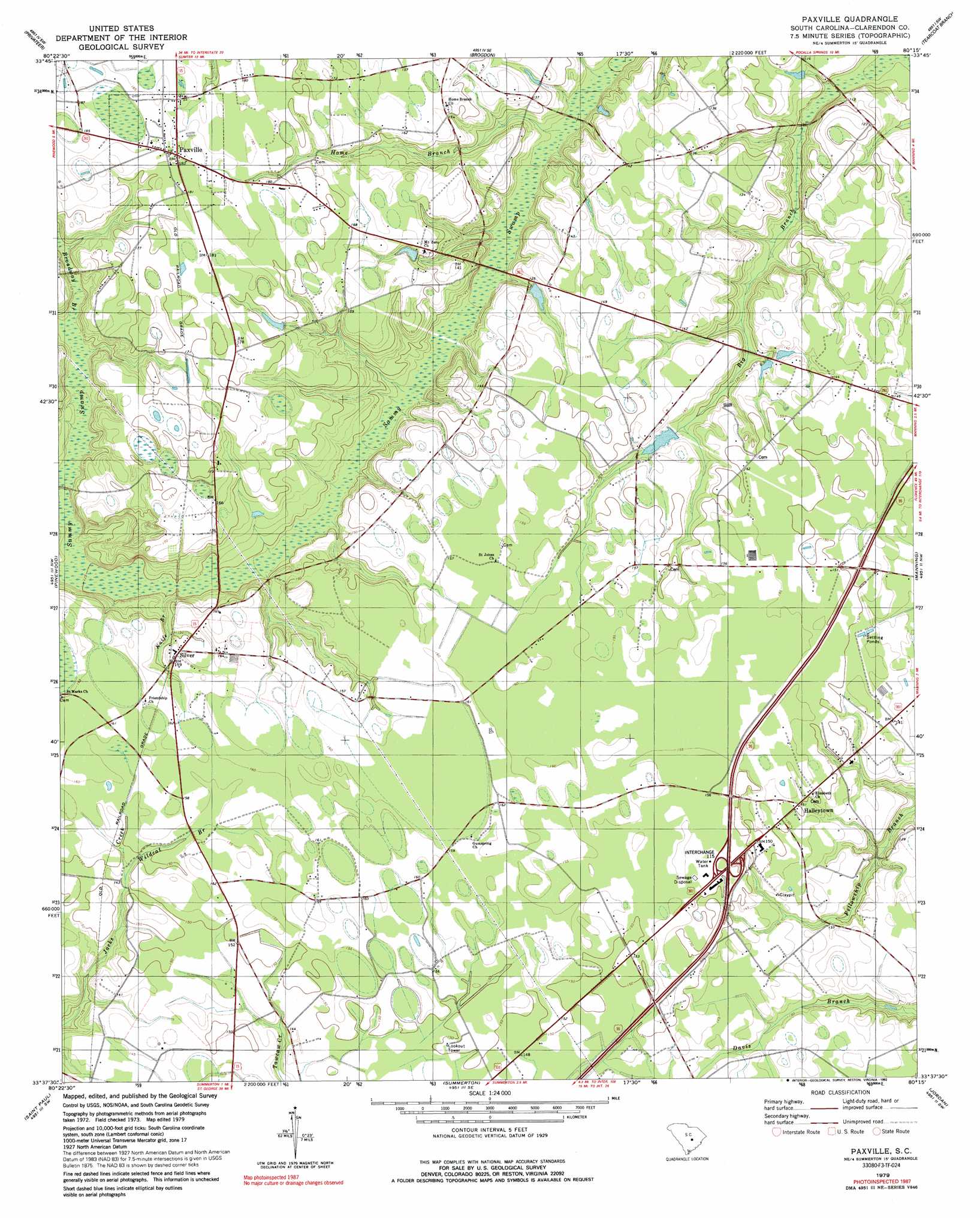
Paxville Topo Map South Carolina
To zoom in, hover over the map of Paxville
USGS Topo Quad 33080f3 - 1:24,000 scale
| Topo Map Name: | Paxville |
| USGS Topo Quad ID: | 33080f3 |
| Print Size: | ca. 21 1/4" wide x 27" high |
| Southeast Coordinates: | 33.625° N latitude / 80.25° W longitude |
| Map Center Coordinates: | 33.6875° N latitude / 80.3125° W longitude |
| U.S. State: | SC |
| Filename: | o33080f3.jpg |
| Download Map JPG Image: | Paxville topo map 1:24,000 scale |
| Map Type: | Topographic |
| Topo Series: | 7.5´ |
| Map Scale: | 1:24,000 |
| Source of Map Images: | United States Geological Survey (USGS) |
| Alternate Map Versions: |
Paxville SC 1979, updated 1980 Download PDF Buy paper map Paxville SC 1979, updated 1992 Download PDF Buy paper map Paxville SC 2011 Download PDF Buy paper map Paxville SC 2014 Download PDF Buy paper map |
1:24,000 Topo Quads surrounding Paxville
Wedgefield |
Sumter West |
Sumter East |
Mayesville |
Turbeville |
Poinsett State Park |
Privateer |
Brogdon |
Tearcoat Branch |
Sardinia |
Lone Star |
Pinewood |
Paxville |
Manning |
Foreston |
Elloree |
Saint Paul |
Summerton |
Jordan |
Butlers Bay |
Felderville |
Vance |
Eutawville |
Eadytown |
Pineville |
> Back to 33080e1 at 1:100,000 scale
> Back to 33080a1 at 1:250,000 scale
> Back to U.S. Topo Maps home
Paxville topo map: Gazetteer
Paxville: Crossings
Interchange 115 elevation 50m 164′Paxville: Dams
Berry Pond Dam D-3491 elevation 40m 131′Edna Ward Pond Dam D-3492 elevation 40m 131′
South Carolina Noname 14012 D-3499 Dam elevation 38m 124′
W J Jackson Pond Dam D-3488 elevation 39m 127′
Paxville: Populated Places
Halleytown elevation 45m 147′Paxville elevation 55m 180′
Silver elevation 48m 157′
Paxville: Post Offices
Paxville Post Office elevation 55m 180′Paxville: Reservoirs
Berry Pond elevation 40m 131′Edna Ward Pond elevation 40m 131′
Lakewood Lake elevation 38m 124′
W J Jackson Pond elevation 39m 127′
Paxville: Streams
Broadway Branch elevation 42m 137′Home Branch elevation 31m 101′
Hungary Hall Branch elevation 39m 127′
Knife Branch elevation 38m 124′
Rosehen Branch elevation 36m 118′
Wildcat Branch elevation 43m 141′
Paxville: Swamps
Rosehen Bay elevation 48m 157′Paxville digital topo map on disk
Buy this Paxville topo map showing relief, roads, GPS coordinates and other geographical features, as a high-resolution digital map file on DVD:
South Carolina, Western North Carolina & Northeastern Georgia
Buy digital topo maps: South Carolina, Western North Carolina & Northeastern Georgia