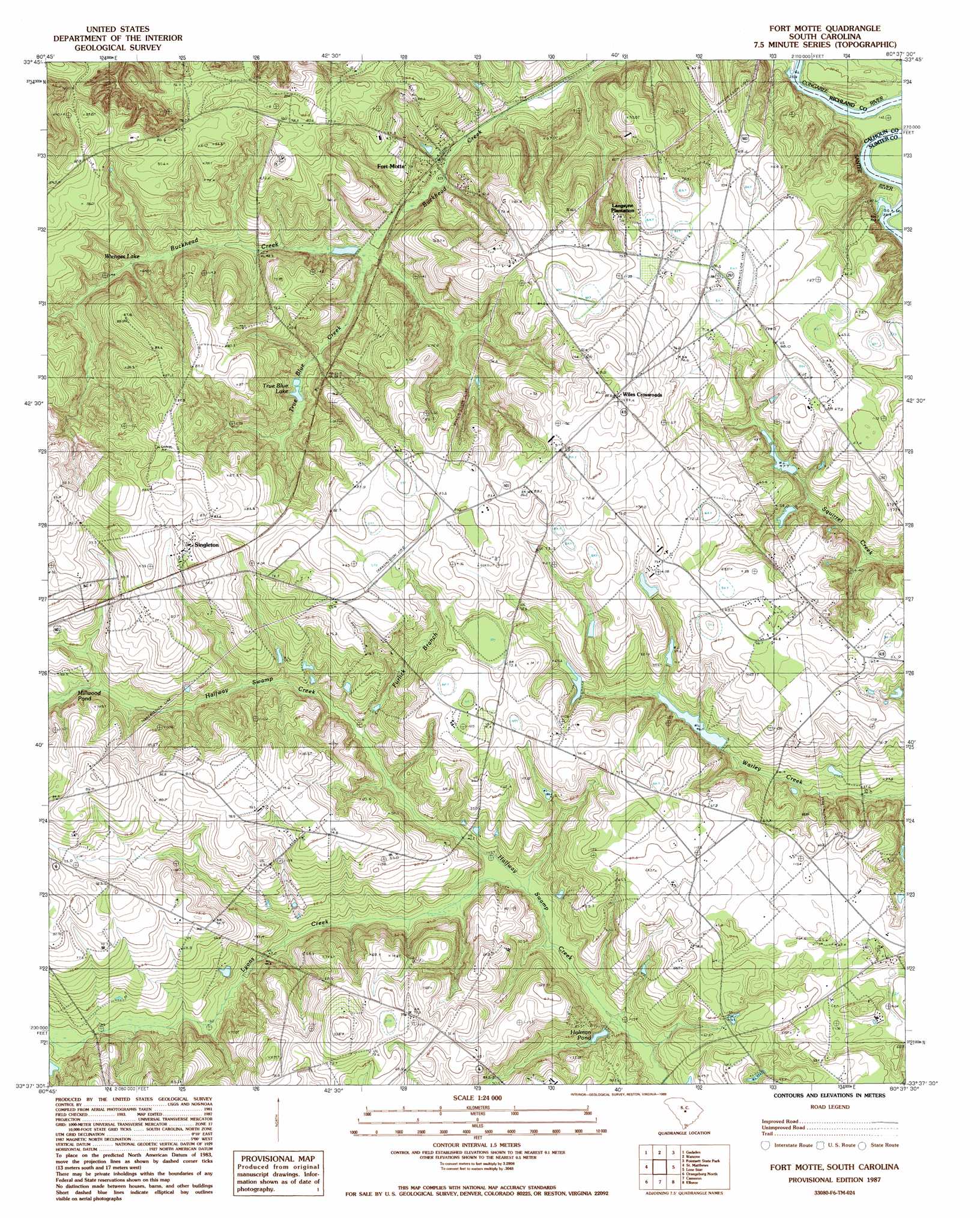
Fort Motte Topo Map South Carolina
To zoom in, hover over the map of Fort Motte
USGS Topo Quad 33080f6 - 1:24,000 scale
| Topo Map Name: | Fort Motte |
| USGS Topo Quad ID: | 33080f6 |
| Print Size: | ca. 21 1/4" wide x 27" high |
| Southeast Coordinates: | 33.625° N latitude / 80.625° W longitude |
| Map Center Coordinates: | 33.6875° N latitude / 80.6875° W longitude |
| U.S. State: | SC |
| Filename: | o33080f6.jpg |
| Download Map JPG Image: | Fort Motte topo map 1:24,000 scale |
| Map Type: | Topographic |
| Topo Series: | 7.5´ |
| Map Scale: | 1:24,000 |
| Source of Map Images: | United States Geological Survey (USGS) |
| Alternate Map Versions: |
Fort Motte SC 1987, updated 1988 Download PDF Buy paper map Fort Motte SC 2012 Download PDF Buy paper map Fort Motte SC 2014 Download PDF Buy paper map |
1:24,000 Topo Quads surrounding Fort Motte
Fort Jackson South |
Congaree |
Eastover |
Wedgefield |
Sumter West |
Saylors Lake |
Gadsden |
Wateree |
Poinsett State Park |
Privateer |
Staley Crossroads |
Saint Mathews |
Fort Motte |
Lone Star |
Pinewood |
Wolfton |
Orangeburg North |
Cameron |
Elloree |
Saint Paul |
Cordova |
Orangeburg South |
Indian Camp Branch |
Felderville |
Vance |
> Back to 33080e1 at 1:100,000 scale
> Back to 33080a1 at 1:250,000 scale
> Back to U.S. Topo Maps home
Fort Motte topo map: Gazetteer
Fort Motte: Airports
Saint Matthews Airport elevation 83m 272′Fort Motte: Dams
Reid House Pond Dam D-2655 elevation 59m 193′Saint Matthews City Sewage Dam D-2919 elevation 71m 232′
Sam Reid Pond Dam D-2658 elevation 55m 180′
Shehane Cabin Pond Dam D-2659 elevation 44m 144′
South Carolina Noname 09023 D-2637 Dam elevation 60m 196′
South Carolina Noname 09024 D-2639 Dam elevation 46m 150′
South Carolina Noname 09039 D-2654 Dam elevation 46m 150′
South Carolina Noname 09044 D-2665 Dam elevation 45m 147′
Sykes Pond Dam D-2636 elevation 64m 209′
Wiles Pond Dam D-2660 elevation 50m 164′
Fort Motte: Lakes
True Blue Lake elevation 48m 157′Fort Motte: Populated Places
Fort Motte elevation 40m 131′Singleton elevation 82m 269′
Wiles Crossroads elevation 88m 288′
Fort Motte: Reservoirs
F M Wannamaker Pond elevation 60m 196′Holman Pond elevation 40m 131′
J L Wannamaker Cabin Pond elevation 76m 249′
Millwood Pond elevation 55m 180′
Reid House Pond elevation 59m 193′
Reid Pond elevation 55m 180′
Shehane Cabin Pond elevation 44m 144′
Shehane Pump House Pond elevation 46m 150′
Spigner Pond elevation 45m 147′
Sykes Pond elevation 64m 209′
Wienges Lake elevation 80m 262′
Wienges Lake elevation 46m 150′
Wiles Pond elevation 50m 164′
Fort Motte: Streams
Antley Spring Branch elevation 51m 167′Furlick Branch elevation 43m 141′
Lyons Creek elevation 40m 131′
True Blue Creek elevation 37m 121′
Fort Motte digital topo map on disk
Buy this Fort Motte topo map showing relief, roads, GPS coordinates and other geographical features, as a high-resolution digital map file on DVD:
South Carolina, Western North Carolina & Northeastern Georgia
Buy digital topo maps: South Carolina, Western North Carolina & Northeastern Georgia