Saint Mathews Topo Map South Carolina
To zoom in, hover over the map of Saint Mathews
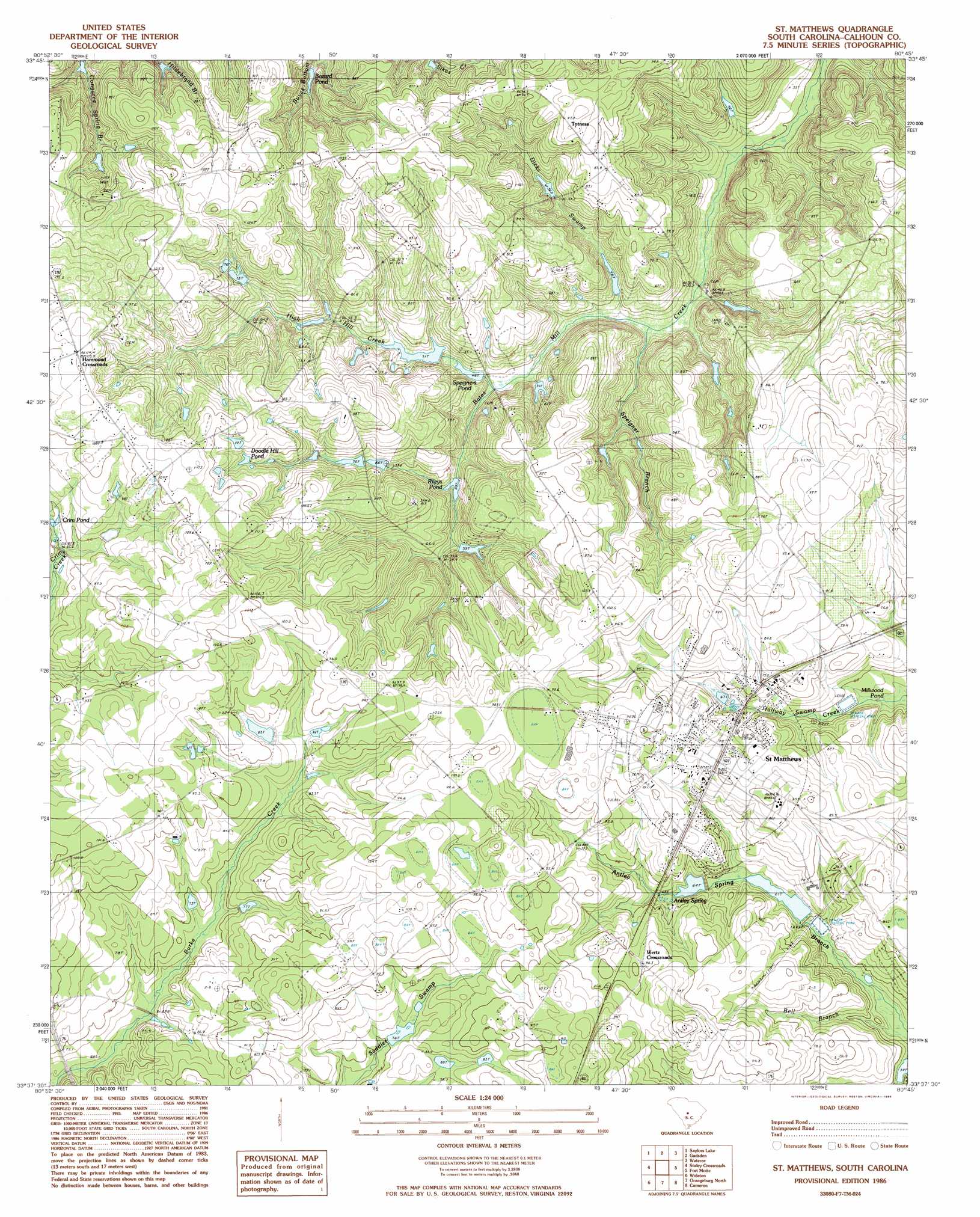
USGS Topo Quad 33080f7 - 1:24,000 scale
| Topo Map Name: | Saint Mathews |
| USGS Topo Quad ID: | 33080f7 |
| Print Size: | ca. 21 1/4" wide x 27" high |
| Southeast Coordinates: | 33.625° N latitude / 80.75° W longitude |
| Map Center Coordinates: | 33.6875° N latitude / 80.8125° W longitude |
| U.S. State: | SC |
| Filename: | o33080f7.jpg |
| Download Map JPG Image: | Saint Mathews topo map 1:24,000 scale |
| Map Type: | Topographic |
| Topo Series: | 7.5´ |
| Map Scale: | 1:24,000 |
| Source of Map Images: | United States Geological Survey (USGS) |
| Alternate Map Versions: |
St. Matthews SC 1986, updated 1986 Download PDF Buy paper map Saint Matthews SC 2011 Download PDF Buy paper map Saint Matthews SC 2014 Download PDF Buy paper map |
1:24,000 Topo Quads surrounding Saint Mathews
Southwest Columbia |
Fort Jackson South |
Congaree |
Eastover |
Wedgefield |
Gaston |
Saylors Lake |
Gadsden |
Wateree |
Poinsett State Park |
Swansea |
Staley Crossroads |
Saint Mathews |
Fort Motte |
Lone Star |
North |
Wolfton |
Orangeburg North |
Cameron |
Elloree |
Norway East |
Cordova |
Orangeburg South |
Indian Camp Branch |
Felderville |
> Back to 33080e1 at 1:100,000 scale
> Back to 33080a1 at 1:250,000 scale
> Back to U.S. Topo Maps home
Saint Mathews topo map: Gazetteer
Saint Mathews: Dams
Bensons Pond Dam D-2626 elevation 53m 173′Bobby Gressett Pond Dam D-2662 elevation 81m 265′
Buycls Swamp Pond Dam D-2928 elevation 45m 147′
Campbell Pond Dam D-2678 elevation 99m 324′
Furtick Pond Dam D-2682 elevation 60m 196′
Griffith Pond Dam D-2679 elevation 83m 272′
J L Wannamaker Pond Dam D-2685 elevation 54m 177′
Paradice Lake Dam D-2629 elevation 56m 183′
Peter Buycls House Pond Dam D-2927 elevation 63m 206′
Saint Matthews Waste Pond Dam D-2638 elevation 57m 187′
Smith Pond Dam D-2680 elevation 58m 190′
Smoke Pond Dam D-2929 elevation 62m 203′
South Carolina Noname 09011 D-2625 Dam elevation 46m 150′
South Carolina Noname 09012 D-2627 Dam elevation 56m 183′
South Carolina Noname 09013 D-2628 Dam elevation 49m 160′
South Carolina Noname 09014 D-2630 Dam elevation 57m 187′
South Carolina Noname 09015 D-2631 Dam elevation 73m 239′
South Carolina Noname 09021 D-2635 Dam elevation 56m 183′
South Carolina Noname 09022 Dam elevation 73m 239′
South Carolina Noname 09041 D-2661 Dam elevation 77m 252′
Strickland Pond Dam D-2683 elevation 45m 147′
Saint Mathews: Populated Places
Hammond Crossroads elevation 113m 370′Saint Matthews elevation 84m 275′
Totness elevation 94m 308′
Wertz Crossroads elevation 88m 288′
Saint Mathews: Post Offices
Saint Mathews Post Office elevation 82m 269′Saint Mathews: Reservoirs
Beckhams Pond elevation 77m 252′Bensons Pond elevation 53m 173′
Bobby Gressett Pond elevation 81m 265′
Bozard Pond elevation 76m 249′
Buycls Swamp Pond elevation 45m 147′
Campbell Pond elevation 99m 324′
Crim Pond elevation 90m 295′
Dents Pond elevation 46m 150′
Doodle Hill Pond elevation 92m 301′
Furtick Pond elevation 60m 196′
Griffith Pond elevation 83m 272′
I Prickett Pond elevation 57m 187′
J L Wannamaker Pond elevation 54m 177′
Lake Helen elevation 56m 183′
Lake Inspiration elevation 73m 239′
Paradice Lake elevation 56m 183′
Peter Buycls House Pond elevation 63m 206′
Raysors Lake elevation 70m 229′
Razor Highway Pond elevation 73m 239′
Rileys Millpond elevation 58m 190′
Rileys Pond elevation 49m 160′
Rogers Pond (historical) elevation 74m 242′
Smith Pond elevation 58m 190′
Smoke Pond elevation 62m 203′
Speigners Pond elevation 46m 150′
Strickland Pond elevation 45m 147′
Wannamakers Pond elevation 56m 183′
Waste Stabilization Pond elevation 57m 187′
Saint Mathews: Springs
Antley Spring elevation 69m 226′Saint Mathews: Streams
Bell Branch elevation 52m 170′Dicks Swamp elevation 38m 124′
High Hill Creek elevation 44m 144′
Saint Mathews digital topo map on disk
Buy this Saint Mathews topo map showing relief, roads, GPS coordinates and other geographical features, as a high-resolution digital map file on DVD:
South Carolina, Western North Carolina & Northeastern Georgia
Buy digital topo maps: South Carolina, Western North Carolina & Northeastern Georgia