Wedgefield Topo Map South Carolina
To zoom in, hover over the map of Wedgefield
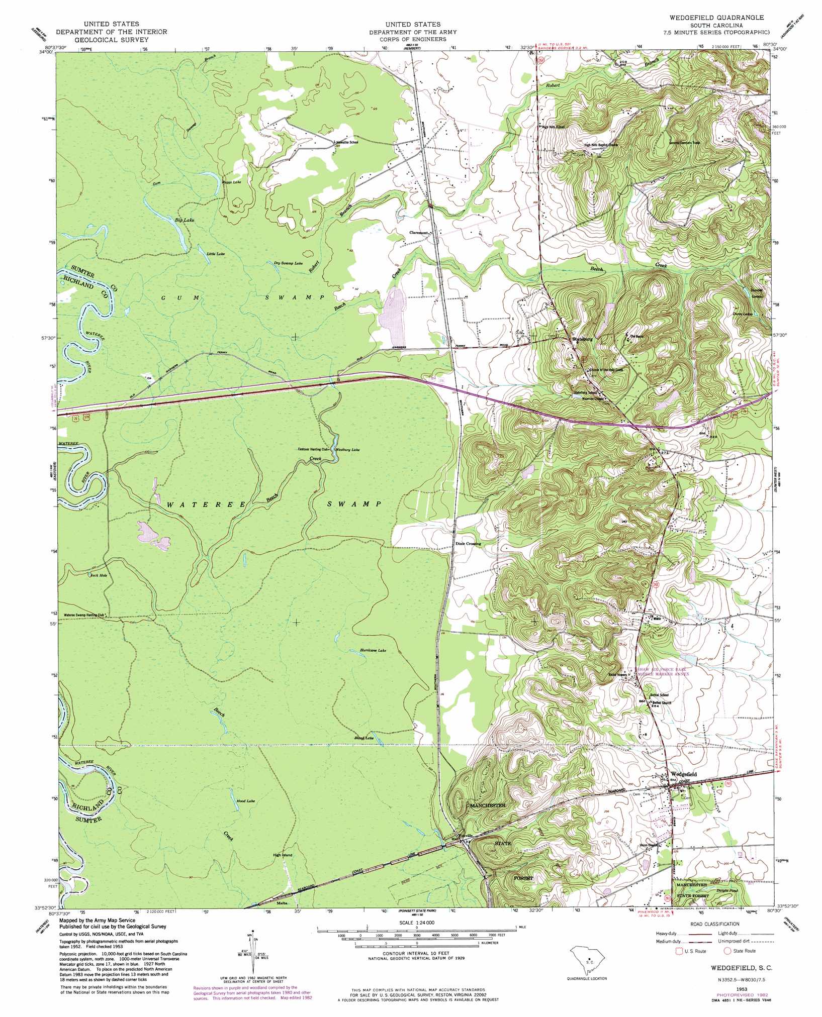
USGS Topo Quad 33080h5 - 1:24,000 scale
| Topo Map Name: | Wedgefield |
| USGS Topo Quad ID: | 33080h5 |
| Print Size: | ca. 21 1/4" wide x 27" high |
| Southeast Coordinates: | 33.875° N latitude / 80.5° W longitude |
| Map Center Coordinates: | 33.9375° N latitude / 80.5625° W longitude |
| U.S. State: | SC |
| Filename: | o33080h5.jpg |
| Download Map JPG Image: | Wedgefield topo map 1:24,000 scale |
| Map Type: | Topographic |
| Topo Series: | 7.5´ |
| Map Scale: | 1:24,000 |
| Source of Map Images: | United States Geological Survey (USGS) |
| Alternate Map Versions: |
Wedgefield SC 1953, updated 1957 Download PDF Buy paper map Wedgefield SC 1953, updated 1957 Download PDF Buy paper map Wedgefield SC 1953, updated 1983 Download PDF Buy paper map Wedgefield SC 2011 Download PDF Buy paper map Wedgefield SC 2014 Download PDF Buy paper map |
1:24,000 Topo Quads surrounding Wedgefield
Elgin |
Lugoff |
Camden South |
Spring Hill |
Bishopville West |
Messers Pond |
Leesburg |
Rembert |
Dalzell |
Oswego |
Congaree |
Eastover |
Wedgefield |
Sumter West |
Sumter East |
Gadsden |
Wateree |
Poinsett State Park |
Privateer |
Brogdon |
Saint Mathews |
Fort Motte |
Lone Star |
Pinewood |
Paxville |
> Back to 33080e1 at 1:100,000 scale
> Back to 33080a1 at 1:250,000 scale
> Back to U.S. Topo Maps home
Wedgefield topo map: Gazetteer
Wedgefield: Dams
Gillespie Pond Dam D-1983 elevation 77m 252′H M McLaurin Pond Dam D-1990 elevation 76m 249′
Mikell Pond Dam D-1984 elevation 34m 111′
Oakland Pond Dam D-1981 elevation 89m 291′
Wedgefield: Islands
High Island elevation 27m 88′Wedgefield: Lakes
Big Lake elevation 32m 104′Bland Lake elevation 30m 98′
Dry Swamp Lake elevation 32m 104′
Hood Lake elevation 28m 91′
Hurricane Lake elevation 30m 98′
Jack Hole elevation 30m 98′
Little Lake elevation 32m 104′
Ruggs Lake elevation 32m 104′
Westbury Lake elevation 30m 98′
Wedgefield: Populated Places
Claremont elevation 40m 131′Dixie Crossing elevation 41m 134′
Foxville elevation 37m 121′
Malta elevation 27m 88′
Springbank Hills elevation 83m 272′
Stateburg elevation 91m 298′
Wedgefield elevation 76m 249′
Wedgewood elevation 64m 209′
Wedgefield: Reservoirs
Dunn Lakes elevation 61m 200′Dwight Pond elevation 54m 177′
Gillespie Pond elevation 77m 252′
McLaurins Pond elevation 76m 249′
Mikell Pond elevation 34m 111′
Oakland Pond elevation 89m 291′
Wedgefield: Streams
Gum Swamp Branch elevation 30m 98′Robert Branch elevation 31m 101′
Wedgefield: Swamps
Gum Swamp elevation 33m 108′Wedgefield digital topo map on disk
Buy this Wedgefield topo map showing relief, roads, GPS coordinates and other geographical features, as a high-resolution digital map file on DVD:
South Carolina, Western North Carolina & Northeastern Georgia
Buy digital topo maps: South Carolina, Western North Carolina & Northeastern Georgia