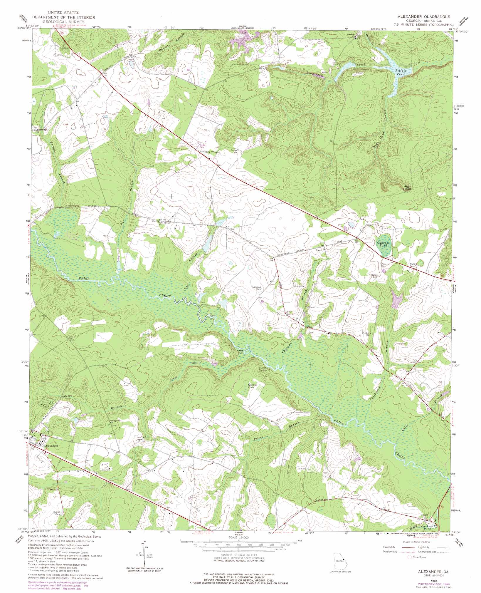
Alexander Topo Map Georgia
To zoom in, hover over the map of Alexander
USGS Topo Quad 33081a7 - 1:24,000 scale
| Topo Map Name: | Alexander |
| USGS Topo Quad ID: | 33081a7 |
| Print Size: | ca. 21 1/4" wide x 27" high |
| Southeast Coordinates: | 33° N latitude / 81.75° W longitude |
| Map Center Coordinates: | 33.0625° N latitude / 81.8125° W longitude |
| U.S. State: | GA |
| Filename: | o33081a7.jpg |
| Download Map JPG Image: | Alexander topo map 1:24,000 scale |
| Map Type: | Topographic |
| Topo Series: | 7.5´ |
| Map Scale: | 1:24,000 |
| Source of Map Images: | United States Geological Survey (USGS) |
| Alternate Map Versions: |
Alexander GA 1964, updated 1965 Download PDF Buy paper map Alexander GA 1964, updated 1989 Download PDF Buy paper map Alexander GA 2011 Download PDF Buy paper map Alexander GA 2014 Download PDF Buy paper map |
1:24,000 Topo Quads surrounding Alexander
Hephzibah |
Mechanic Hill |
Jackson |
New Ellenton Sw |
New Ellenton Se |
Storys Millpond |
Mcbean |
Shell Bluff Landing |
Girard Nw |
Girard Ne |
Waynesboro |
Idlewood |
Alexander |
Girard |
Millett |
Bellevue |
Perkins |
Sardis |
Hilltonia |
Burtons Ferry Landing |
Birdsville |
Millen |
Bay Branch |
Sylvania North |
Jacksonboro Bridge |
> Back to 33081a1 at 1:100,000 scale
> Back to 33080a1 at 1:250,000 scale
> Back to U.S. Topo Maps home
Alexander topo map: Gazetteer
Alexander: Dams
Fenwick Lake Dam elevation 59m 193′Telfair Pond Dam elevation 32m 104′
Alexander: Lakes
Cypress Pond elevation 74m 242′Gordon Pond elevation 68m 223′
Alexander: Populated Places
Telfair Woods elevation 85m 278′Alexander: Reservoirs
Fenwick Lake elevation 59m 193′Telfair Pond elevation 32m 104′
Alexander: Streams
Barton Branch elevation 48m 157′Bates Branch elevation 41m 134′
Boggy Gut elevation 39m 127′
Chatman Branch elevation 43m 141′
Chickasaw Branch elevation 41m 134′
Cox Branch elevation 47m 154′
Daniels Branch elevation 32m 104′
High Head Branch elevation 32m 104′
Jobs Branch elevation 45m 147′
Peters Branch elevation 42m 137′
Poley Branch elevation 52m 170′
Rocky Creek elevation 44m 144′
Alexander: Summits
High Head elevation 51m 167′Alexander: Swamps
Cushner Pond elevation 41m 134′Little Hell elevation 44m 144′
Alexander digital topo map on disk
Buy this Alexander topo map showing relief, roads, GPS coordinates and other geographical features, as a high-resolution digital map file on DVD:
South Carolina, Western North Carolina & Northeastern Georgia
Buy digital topo maps: South Carolina, Western North Carolina & Northeastern Georgia