Girard Nw Topo Map South Carolina
To zoom in, hover over the map of Girard Nw
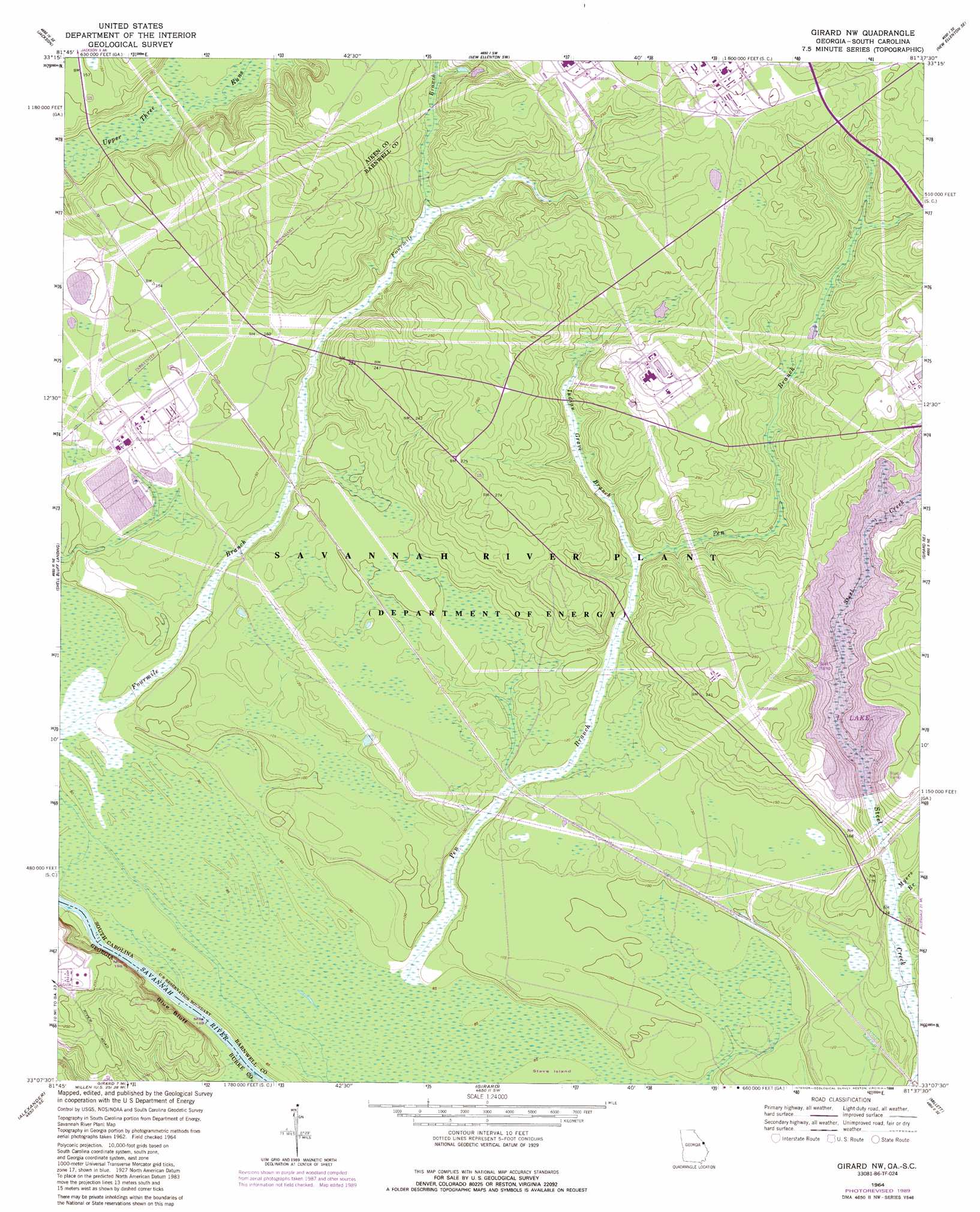
USGS Topo Quad 33081b6 - 1:24,000 scale
| Topo Map Name: | Girard Nw |
| USGS Topo Quad ID: | 33081b6 |
| Print Size: | ca. 21 1/4" wide x 27" high |
| Southeast Coordinates: | 33.125° N latitude / 81.625° W longitude |
| Map Center Coordinates: | 33.1875° N latitude / 81.6875° W longitude |
| U.S. States: | SC, GA |
| Filename: | o33081b6.jpg |
| Download Map JPG Image: | Girard Nw topo map 1:24,000 scale |
| Map Type: | Topographic |
| Topo Series: | 7.5´ |
| Map Scale: | 1:24,000 |
| Source of Map Images: | United States Geological Survey (USGS) |
| Alternate Map Versions: |
Girard NW SC 1964, updated 1965 Download PDF Buy paper map Girard NW SC 1964, updated 1981 Download PDF Buy paper map Girard NW SC 1964, updated 1989 Download PDF Buy paper map Girard NW SC 2011 Download PDF Buy paper map Girard NW SC 2014 Download PDF Buy paper map |
| FStopo: | US Forest Service topo Girard NW is available: Download FStopo PDF Download FStopo TIF |
1:24,000 Topo Quads surrounding Girard Nw
Augusta East |
Hollow Creek |
New Ellenton |
Windsor |
Williston |
Mechanic Hill |
Jackson |
New Ellenton Sw |
New Ellenton Se |
Long Branch |
Mcbean |
Shell Bluff Landing |
Girard Nw |
Girard Ne |
Snelling |
Idlewood |
Alexander |
Girard |
Millett |
Martin |
Perkins |
Sardis |
Hilltonia |
Burtons Ferry Landing |
Bull Pond |
> Back to 33081a1 at 1:100,000 scale
> Back to 33080a1 at 1:250,000 scale
> Back to U.S. Topo Maps home
Girard Nw topo map: Gazetteer
Girard Nw: Airports
Vegp Visitor Center Heliport elevation 37m 121′Girard Nw: Cliffs
Blue Bluff elevation 33m 108′Girard Nw: Dams
Srp Number 16-403-D D-3073 Dam elevation 36m 118′Srp Number 18-488-10 D-3077 Dam elevation 42m 137′
Girard Nw: Populated Places
Ashley Place (historical) elevation 77m 252′Leigh (historical) elevation 46m 150′
Robbins (historical) elevation 40m 131′
Girard Nw: Reservoirs
Castles Pond (historical) elevation 30m 98′Girard Nw: Streams
Beaverdam Creek elevation 24m 78′Fourmile Branch elevation 25m 82′
Indian Grave Branch elevation 42m 137′
Meyers Branch elevation 32m 104′
Girard Nw digital topo map on disk
Buy this Girard Nw topo map showing relief, roads, GPS coordinates and other geographical features, as a high-resolution digital map file on DVD:
South Carolina, Western North Carolina & Northeastern Georgia
Buy digital topo maps: South Carolina, Western North Carolina & Northeastern Georgia