Bamberg Topo Map South Carolina
To zoom in, hover over the map of Bamberg
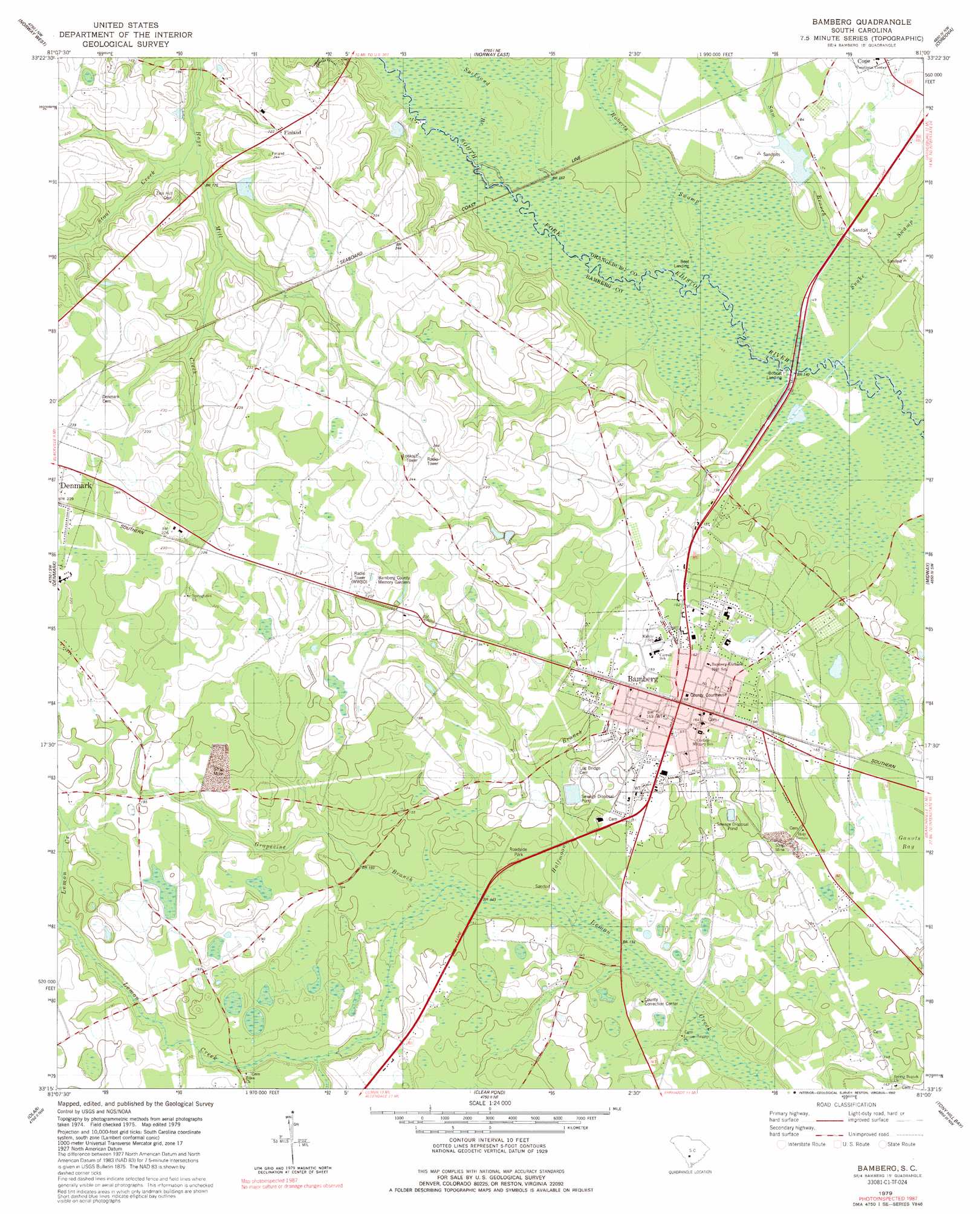
USGS Topo Quad 33081c1 - 1:24,000 scale
| Topo Map Name: | Bamberg |
| USGS Topo Quad ID: | 33081c1 |
| Print Size: | ca. 21 1/4" wide x 27" high |
| Southeast Coordinates: | 33.25° N latitude / 81° W longitude |
| Map Center Coordinates: | 33.3125° N latitude / 81.0625° W longitude |
| U.S. State: | SC |
| Filename: | o33081c1.jpg |
| Download Map JPG Image: | Bamberg topo map 1:24,000 scale |
| Map Type: | Topographic |
| Topo Series: | 7.5´ |
| Map Scale: | 1:24,000 |
| Source of Map Images: | United States Geological Survey (USGS) |
| Alternate Map Versions: |
Bamberg SC 1979, updated 1980 Download PDF Buy paper map Bamberg SC 2011 Download PDF Buy paper map Bamberg SC 2014 Download PDF Buy paper map |
1:24,000 Topo Quads surrounding Bamberg
Salley |
Harleys Millpond |
North |
Wolfton |
Orangeburg North |
Springfield |
Norway West |
Norway East |
Cordova |
Orangeburg South |
Blackville |
Denmark |
Bamberg |
Midway |
Branchville North |
Barnwell |
Olar |
Clear Pond |
Tony Hill Bay |
Branchville South |
Allendale |
Sycamore |
Ehrhardt |
Lodge |
Williams |
> Back to 33081a1 at 1:100,000 scale
> Back to 33080a1 at 1:250,000 scale
> Back to U.S. Topo Maps home
Bamberg topo map: Gazetteer
Bamberg: Airports
Bamberg County Airport elevation 66m 216′Bamberg Hospital Heliport elevation 51m 167′
Bamberg: Bridges
New Bridge elevation 42m 137′Bamberg: Dams
Edisto Pond Dam D-2810 elevation 60m 196′South Carolina Noname 38054 D-3776 Dam elevation 49m 160′
Bamberg: Parks
Bamberg Historic District elevation 53m 173′Bamberg: Populated Places
Bamberg elevation 51m 167′Bobcat Landing elevation 41m 134′
Finland elevation 70m 229′
Loraine (historical) elevation 68m 223′
Ott (historical) elevation 70m 229′
Bamberg: Post Offices
Bamberg Post Office elevation 51m 167′Bamberg: Reservoirs
Edisto Pond elevation 60m 196′Bamberg: Springs
Glendale Springs elevation 43m 141′Bamberg: Streams
Grapevine Branch elevation 39m 127′Halfmoon Branch elevation 41m 134′
Roberts Swamp elevation 42m 137′
Sam Branch elevation 42m 137′
Snake Swamp elevation 41m 134′
Stout Creek elevation 50m 164′
Sucksand Branch elevation 43m 141′
Bamberg: Summits
Quartemans Hill elevation 69m 226′Bamberg: Swamps
Ginhouse Pond elevation 43m 141′Bamberg digital topo map on disk
Buy this Bamberg topo map showing relief, roads, GPS coordinates and other geographical features, as a high-resolution digital map file on DVD:
South Carolina, Western North Carolina & Northeastern Georgia
Buy digital topo maps: South Carolina, Western North Carolina & Northeastern Georgia