Norway East Topo Map South Carolina
To zoom in, hover over the map of Norway East
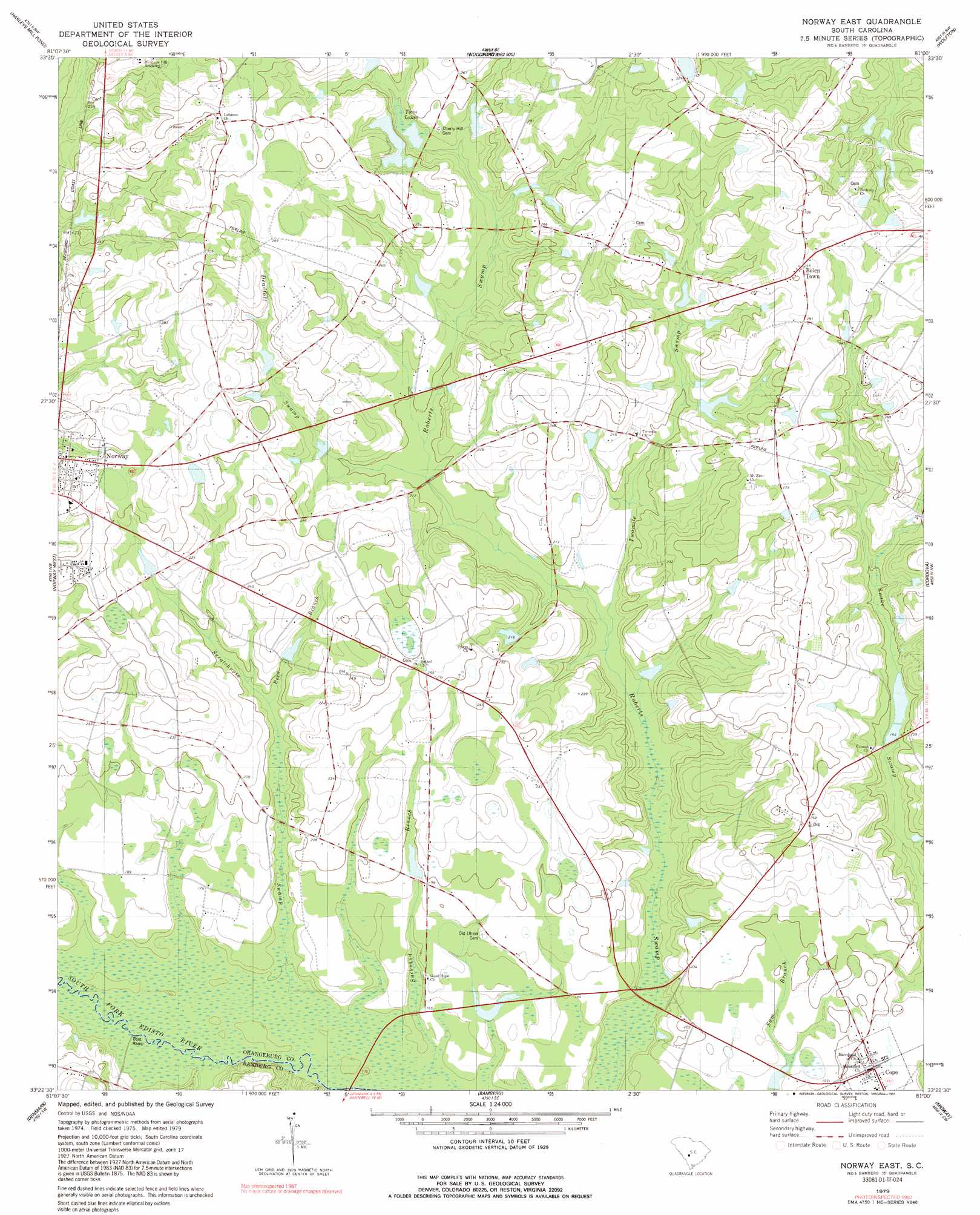
USGS Topo Quad 33081d1 - 1:24,000 scale
| Topo Map Name: | Norway East |
| USGS Topo Quad ID: | 33081d1 |
| Print Size: | ca. 21 1/4" wide x 27" high |
| Southeast Coordinates: | 33.375° N latitude / 81° W longitude |
| Map Center Coordinates: | 33.4375° N latitude / 81.0625° W longitude |
| U.S. State: | SC |
| Filename: | o33081d1.jpg |
| Download Map JPG Image: | Norway East topo map 1:24,000 scale |
| Map Type: | Topographic |
| Topo Series: | 7.5´ |
| Map Scale: | 1:24,000 |
| Source of Map Images: | United States Geological Survey (USGS) |
| Alternate Map Versions: |
Norway East SC 1979, updated 1979 Download PDF Buy paper map Norway East SC 1979, updated 1991 Download PDF Buy paper map Norway East SC 2011 Download PDF Buy paper map Norway East SC 2014 Download PDF Buy paper map |
1:24,000 Topo Quads surrounding Norway East
Wagener |
Pond Branch |
Swansea |
Staley Crossroads |
Saint Mathews |
Salley |
Harleys Millpond |
North |
Wolfton |
Orangeburg North |
Springfield |
Norway West |
Norway East |
Cordova |
Orangeburg South |
Blackville |
Denmark |
Bamberg |
Midway |
Branchville North |
Barnwell |
Olar |
Clear Pond |
Tony Hill Bay |
Branchville South |
> Back to 33081a1 at 1:100,000 scale
> Back to 33080a1 at 1:250,000 scale
> Back to U.S. Topo Maps home
Norway East topo map: Gazetteer
Norway East: Bridges
Julius B Ness Bridge elevation 50m 164′Norway East: Dams
Lewis Davis Pond Dam D-3730 elevation 71m 232′R P Bonnette Pond Dam D-3753 elevation 67m 219′
South Carolina Noname 38014 D-3732 Dam elevation 69m 226′
South Carolina Noname 38045 D-3731 Dam elevation 72m 236′
South Carolina Noname 38046 D-3775 Dam elevation 50m 164′
South Carolina Noname 38053 D-3766 Dam elevation 62m 203′
South Carolina Noname 38071 D-3777 Dam elevation 55m 180′
South Carolina Noname 38079 D-3751 Dam elevation 73m 239′
Vallentine Pond Dam D-3767 elevation 54m 177′
Whetstone Fishing Lake Dam D-3765 elevation 58m 190′
Williams Pond Dam D-3749 elevation 65m 213′
Williamsons Pond Dam D-3750 elevation 76m 249′
Norway East: Islands
Old Forty Acre Island elevation 49m 160′Snow Island elevation 48m 157′
Norway East: Lakes
Twelvemile Pond elevation 91m 298′Norway East: Populated Places
Bolen Town elevation 91m 298′Cope elevation 59m 193′
Norway East: Post Offices
Cope Post Office elevation 59m 193′Norway East: Reservoirs
Copes Pond elevation 55m 180′Fogle Mill Pond elevation 62m 203′
John Fogle Pond elevation 69m 226′
Twin Lakes elevation 72m 236′
Norway East: Streams
Deadfall Swamp elevation 60m 196′Hayes Mill Creek elevation 46m 150′
Red Branch elevation 54m 177′
Scratchnose Swamp elevation 47m 154′
Twomile Swamp elevation 51m 167′
Norway East digital topo map on disk
Buy this Norway East topo map showing relief, roads, GPS coordinates and other geographical features, as a high-resolution digital map file on DVD:
South Carolina, Western North Carolina & Northeastern Georgia
Buy digital topo maps: South Carolina, Western North Carolina & Northeastern Georgia