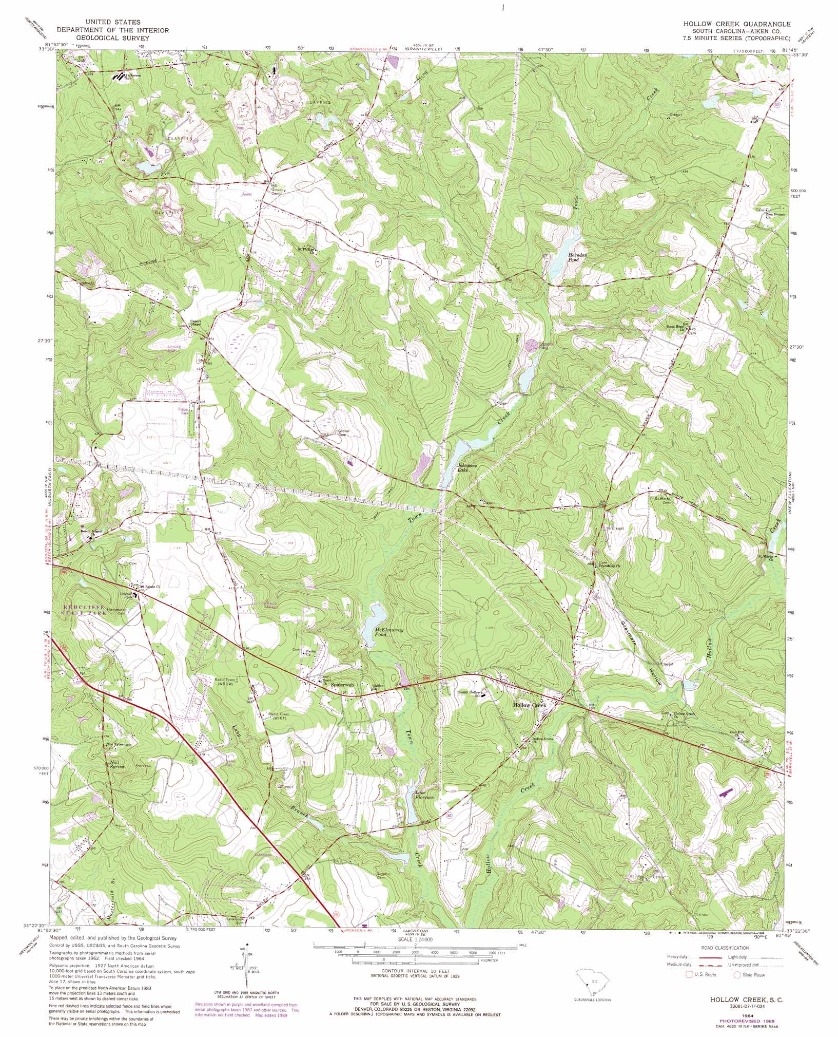
Hollow Creek Topo Map South Carolina
To zoom in, hover over the map of Hollow Creek
USGS Topo Quad 33081d7 - 1:24,000 scale
| Topo Map Name: | Hollow Creek |
| USGS Topo Quad ID: | 33081d7 |
| Print Size: | ca. 21 1/4" wide x 27" high |
| Southeast Coordinates: | 33.375° N latitude / 81.75° W longitude |
| Map Center Coordinates: | 33.4375° N latitude / 81.8125° W longitude |
| U.S. State: | SC |
| Filename: | o33081d7.jpg |
| Download Map JPG Image: | Hollow Creek topo map 1:24,000 scale |
| Map Type: | Topographic |
| Topo Series: | 7.5´ |
| Map Scale: | 1:24,000 |
| Source of Map Images: | United States Geological Survey (USGS) |
| Alternate Map Versions: |
Hollow Creek SC 1964, updated 1966 Download PDF Buy paper map Hollow Creek SC 1964, updated 1973 Download PDF Buy paper map Hollow Creek SC 1964, updated 1989 Download PDF Buy paper map Hollow Creek SC 2011 Download PDF Buy paper map Hollow Creek SC 2014 Download PDF Buy paper map |
| FStopo: | US Forest Service topo Hollow Creek is available: Download FStopo PDF Download FStopo TIF |
1:24,000 Topo Quads surrounding Hollow Creek
Colliers |
Ropers Crossroads |
Trenton |
Aiken Nw |
Foxtown |
Martinez |
North Augusta |
Graniteville |
Aiken |
Oakwood |
Augusta West |
Augusta East |
Hollow Creek |
New Ellenton |
Windsor |
Hephzibah |
Mechanic Hill |
Jackson |
New Ellenton Sw |
New Ellenton Se |
Storys Millpond |
Mcbean |
Shell Bluff Landing |
Girard Nw |
Girard Ne |
> Back to 33081a1 at 1:100,000 scale
> Back to 33080a1 at 1:250,000 scale
> Back to U.S. Topo Maps home
Hollow Creek topo map: Gazetteer
Hollow Creek: Airports
Harman Airport elevation 133m 436′Hollow Creek: Dams
Burgess Lake Dam D-2025 elevation 74m 242′Mixon Lake Dam D-2053 elevation 50m 164′
South Carolina Noname 02003 D-1992 Dam elevation 62m 203′
South Carolina Noname 02012 D-1996 Dam elevation 53m 173′
South Carolina Noname 02052 D-2011 Dam elevation 59m 193′
South Carolina Noname 02068 D-2016 Dam elevation 84m 275′
South Carolina Noname 02070 D-2017 Dam elevation 74m 242′
South Carolina Noname 02077 D-2018 Dam elevation 74m 242′
Wood Valley Dam D-2138 elevation 139m 456′
Hollow Creek: Lakes
Herndon Pond elevation 84m 275′Lake Johnsons elevation 71m 232′
McElmurray Pond elevation 62m 203′
Hollow Creek: Parks
Redcliffe State Park elevation 118m 387′Hollow Creek: Populated Places
Hollow Creek elevation 59m 193′Pembrook elevation 127m 416′
Russell Hill elevation 118m 387′
Spiderweb elevation 107m 351′
Stone Gap elevation 109m 357′
Wood Valley elevation 138m 452′
Hollow Creek: Reservoirs
Boyd Pond elevation 74m 242′Burgess Lake elevation 74m 242′
Celmurray Pond elevation 62m 203′
Georges Pond elevation 74m 242′
Herndon Pond elevation 84m 275′
Lake Florence elevation 53m 173′
Lake Florence elevation 53m 173′
Lower McElmurray Lake elevation 59m 193′
Mixon Lake elevation 50m 164′
Wood Valley Lake elevation 139m 456′
Hollow Creek: Springs
Nail Spring elevation 76m 249′Hollow Creek: Streams
Dry Branch elevation 65m 213′Long Branch elevation 47m 154′
Hollow Creek: Valleys
Graymare Hollow elevation 58m 190′Hollow Creek digital topo map on disk
Buy this Hollow Creek topo map showing relief, roads, GPS coordinates and other geographical features, as a high-resolution digital map file on DVD:
South Carolina, Western North Carolina & Northeastern Georgia
Buy digital topo maps: South Carolina, Western North Carolina & Northeastern Georgia