Ridge Spring Topo Map South Carolina
To zoom in, hover over the map of Ridge Spring
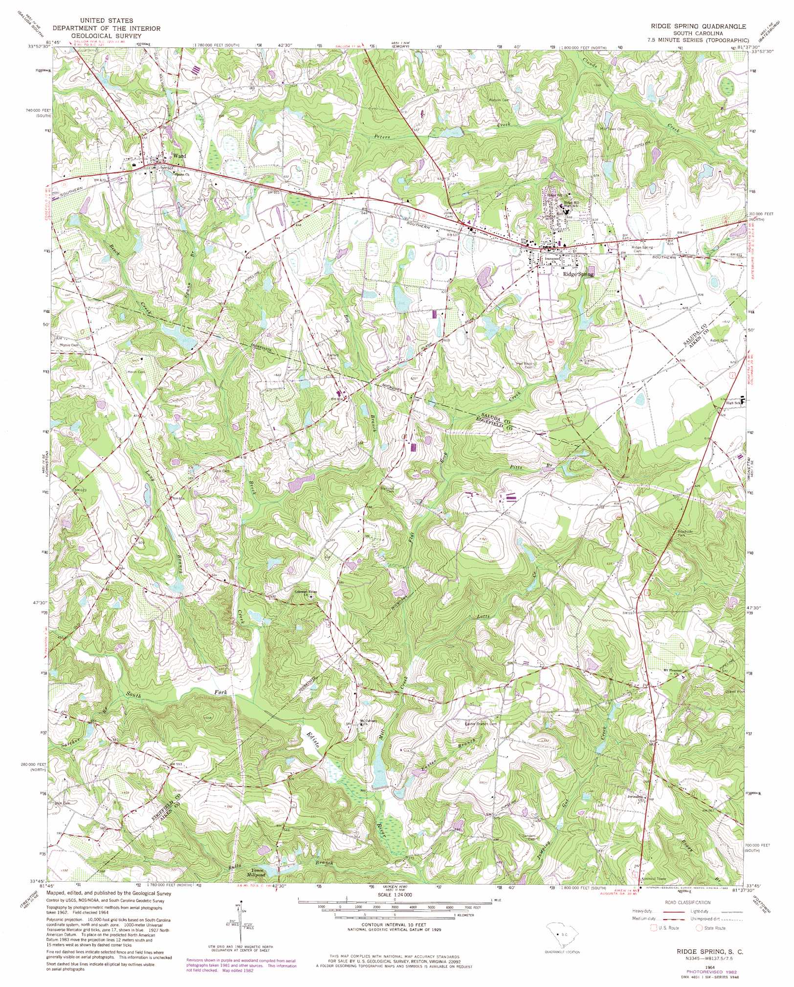
USGS Topo Quad 33081g6 - 1:24,000 scale
| Topo Map Name: | Ridge Spring |
| USGS Topo Quad ID: | 33081g6 |
| Print Size: | ca. 21 1/4" wide x 27" high |
| Southeast Coordinates: | 33.75° N latitude / 81.625° W longitude |
| Map Center Coordinates: | 33.8125° N latitude / 81.6875° W longitude |
| U.S. State: | SC |
| Filename: | o33081g6.jpg |
| Download Map JPG Image: | Ridge Spring topo map 1:24,000 scale |
| Map Type: | Topographic |
| Topo Series: | 7.5´ |
| Map Scale: | 1:24,000 |
| Source of Map Images: | United States Geological Survey (USGS) |
| Alternate Map Versions: |
Ridge Spring SC 1964, updated 1965 Download PDF Buy paper map Ridge Spring SC 1964, updated 1983 Download PDF Buy paper map Ridge Spring SC 2011 Download PDF Buy paper map Ridge Spring SC 2014 Download PDF Buy paper map |
1:24,000 Topo Quads surrounding Ridge Spring
Good Hope |
Saluda North |
Denny |
Delmar |
Lake Murray West |
Owdoms |
Saluda South |
Emory |
Batesburg |
Gilbert |
Edgefield |
Johnston |
Ridge Spring |
Monetta |
Steedman |
Ropers Crossroads |
Trenton |
Aiken Nw |
Foxtown |
Seivern |
North Augusta |
Graniteville |
Aiken |
Oakwood |
Kitchings Mill |
> Back to 33081e1 at 1:100,000 scale
> Back to 33080a1 at 1:250,000 scale
> Back to U.S. Topo Maps home
Ridge Spring topo map: Gazetteer
Ridge Spring: Dams
Boatwrights Pond Dam D-1157 elevation 169m 554′Cullums Pond Dam D-1600 elevation 179m 587′
J C Watson Pond Dam D-1601 elevation 180m 590′
R M Watsons Pond D-1156 Dam elevation 180m 590′
Reid Lake Dam D-2009 elevation 121m 396′
South Carolina Noname 02063 D-2015 Dam elevation 131m 429′
South Carolina Noname 19013 D-0609 Dam elevation 163m 534′
South Carolina Noname 41008 D-1206 Dam elevation 184m 603′
South Carolina Noname 41010 D-1200 Dam elevation 175m 574′
South Carolina Noname 41012 D-1205 Dam elevation 167m 547′
Ridge Spring: Parks
Aiken Wayside Park elevation 176m 577′Ridge Spring: Populated Places
Ridge Spring elevation 193m 633′Ward elevation 203m 666′
Ridge Spring: Reservoirs
Boatwrights Pond elevation 169m 554′Cullums Pond elevation 179m 587′
Durkes Pond elevation 148m 485′
J C Watson Pond elevation 180m 590′
R M Watsons Pond elevation 180m 590′
Reid Lake elevation 121m 396′
Ridgeview Lake elevation 163m 534′
Sanders Pond elevation 130m 426′
Scott Pond elevation 156m 511′
Yonce Millpond elevation 131m 429′
Ridge Spring: Streams
Beech Creek elevation 123m 403′Bog Branch elevation 139m 456′
Bulls Branch elevation 112m 367′
Easter Branch elevation 116m 380′
Flat Rock Creek elevation 124m 406′
Long Branch elevation 125m 410′
Lotts Creek elevation 124m 406′
Mill Creek elevation 116m 380′
Peters Creek elevation 150m 492′
Pitts Branch elevation 143m 469′
Satcher Branch elevation 130m 426′
Spann Branch elevation 164m 538′
Ridge Spring digital topo map on disk
Buy this Ridge Spring topo map showing relief, roads, GPS coordinates and other geographical features, as a high-resolution digital map file on DVD:
South Carolina, Western North Carolina & Northeastern Georgia
Buy digital topo maps: South Carolina, Western North Carolina & Northeastern Georgia