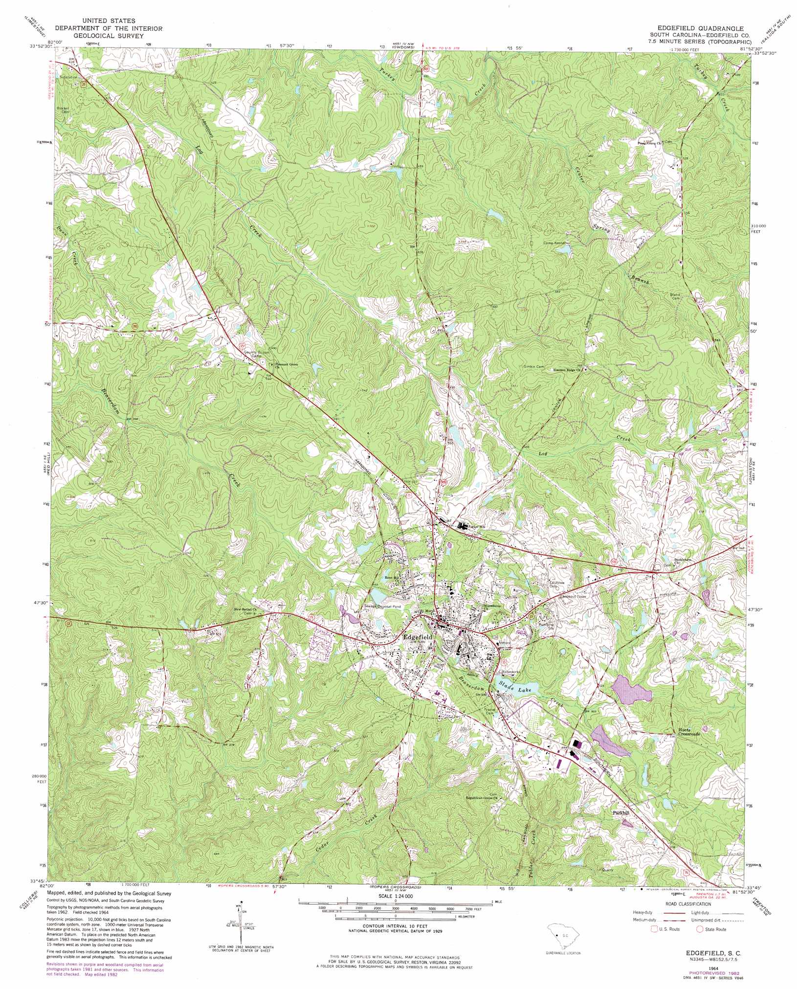
Edgefield Topo Map South Carolina
To zoom in, hover over the map of Edgefield
USGS Topo Quad 33081g8 - 1:24,000 scale
| Topo Map Name: | Edgefield |
| USGS Topo Quad ID: | 33081g8 |
| Print Size: | ca. 21 1/4" wide x 27" high |
| Southeast Coordinates: | 33.75° N latitude / 81.875° W longitude |
| Map Center Coordinates: | 33.8125° N latitude / 81.9375° W longitude |
| U.S. State: | SC |
| Filename: | o33081g8.jpg |
| Download Map JPG Image: | Edgefield topo map 1:24,000 scale |
| Map Type: | Topographic |
| Topo Series: | 7.5´ |
| Map Scale: | 1:24,000 |
| Source of Map Images: | United States Geological Survey (USGS) |
| Alternate Map Versions: |
Edgefield SC 1964, updated 1966 Download PDF Buy paper map Edgefield SC 1964, updated 1982 Download PDF Buy paper map Edgefield SC 2011 Download PDF Buy paper map Edgefield SC 2014 Download PDF Buy paper map |
1:24,000 Topo Quads surrounding Edgefield
Bradley |
Kirksey |
Good Hope |
Saluda North |
Denny |
Winterseat |
Limestone |
Owdoms |
Saluda South |
Emory |
Parksville |
Red Hill |
Edgefield |
Johnston |
Ridge Spring |
Clarks Hill |
Colliers |
Ropers Crossroads |
Trenton |
Aiken Nw |
Evans |
Martinez |
North Augusta |
Graniteville |
Aiken |
> Back to 33081e1 at 1:100,000 scale
> Back to 33080a1 at 1:250,000 scale
> Back to U.S. Topo Maps home
Edgefield topo map: Gazetteer
Edgefield: Dams
South Carolina Noname 01108 D-0892 Dam elevation 157m 515′South Carolina Noname 01109 D-0891 Dam elevation 152m 498′
South Carolina Noname 19001 D-0910 Dam elevation 146m 479′
Edgefield: Parks
Edgefield Historic District elevation 160m 524′Edgefield: Populated Places
Edgefield elevation 162m 531′Huets Crossroads elevation 181m 593′
Parkhill elevation 173m 567′
Edgefield: Reservoirs
Odell Memorial Lake elevation 152m 498′Slade Lake elevation 146m 479′
Edgefield: Streams
Center Spring Branch elevation 119m 390′Edgefield digital topo map on disk
Buy this Edgefield topo map showing relief, roads, GPS coordinates and other geographical features, as a high-resolution digital map file on DVD:
South Carolina, Western North Carolina & Northeastern Georgia
Buy digital topo maps: South Carolina, Western North Carolina & Northeastern Georgia