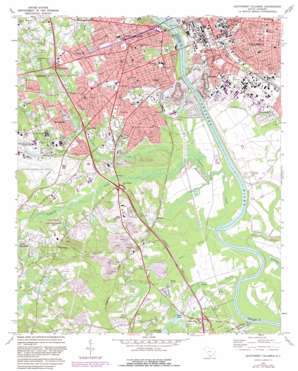
Southwest Columbia Topo Map South Carolina
To zoom in, hover over the map of Southwest Columbia
USGS Topo Quad 33081h1 - 1:24,000 scale
| Topo Map Name: | Southwest Columbia |
| USGS Topo Quad ID: | 33081h1 |
| Print Size: | ca. 21 1/4" wide x 27" high |
| Southeast Coordinates: | 33.875° N latitude / 81° W longitude |
| Map Center Coordinates: | 33.9375° N latitude / 81.0625° W longitude |
| U.S. State: | SC |
| Filename: | o33081h1.jpg |
| Download Map JPG Image: | Southwest Columbia topo map 1:24,000 scale |
| Map Type: | Topographic |
| Topo Series: | 7.5´ |
| Map Scale: | 1:24,000 |
| Source of Map Images: | United States Geological Survey (USGS) |
| Alternate Map Versions: |
Southwest Columbia SC 1972, updated 1975 Download PDF Buy paper map Southwest Columbia SC 1972, updated 1983 Download PDF Buy paper map Southwest Columbia SC 2011 Download PDF Buy paper map Southwest Columbia SC 2014 Download PDF Buy paper map |
1:24,000 Topo Quads surrounding Southwest Columbia
> Back to 33081e1 at 1:100,000 scale
> Back to 33080a1 at 1:250,000 scale
> Back to U.S. Topo Maps home
Southwest Columbia topo map: Gazetteer
Southwest Columbia: Airports
Columbia Metropolitan Airport elevation 68m 223′Owens Field Airport elevation 58m 190′
Southwest Columbia: Areas
The Horseshoe elevation 98m 321′Southwest Columbia: Bridges
Gervais Street Bridge elevation 36m 118′Southwest Columbia: Crossings
Interchange 111 elevation 87m 285′Interchange 113 elevation 54m 177′
Interchange 115 elevation 46m 150′
Interchange 116 elevation 58m 190′
Interchange 119 elevation 52m 170′
Southwest Columbia: Dams
Batesburg Reservoir Dam D-0928 elevation 36m 118′South Carolina Noname 32040 D-0991 Dam elevation 55m 180′
South Carolina Noname 32041 D-0986 Dam elevation 46m 150′
South Carolina Noname 32086 D-0987 Dam elevation 52m 170′
Southwest Columbia: Lakes
Big Lake elevation 37m 121′Horse Pond elevation 84m 275′
Stanley Pond elevation 60m 196′
Southwest Columbia: Mines
Cayce Quarry elevation 56m 183′Columbia Quarry elevation 45m 147′
Southwest Columbia: Parks
Bicentennial Park elevation 40m 131′Emily Douglas Park elevation 80m 262′
Gibbes Green elevation 92m 301′
Guignard Park elevation 51m 167′
Hollywood Park elevation 90m 295′
Maxcy Gregg Park elevation 62m 203′
New Brookland Historic District elevation 59m 193′
Oakhurst Park elevation 63m 206′
Pacific Park elevation 51m 167′
West Gervais Street Historic District elevation 82m 269′
Williams-Brice Stadium elevation 61m 200′
Southwest Columbia: Populated Places
Apollo Gardens elevation 70m 229′Arborgate elevation 67m 219′
Arthurtown elevation 49m 160′
Brookwood elevation 63m 206′
Cayce elevation 73m 239′
Charwood elevation 83m 272′
Dixiana elevation 55m 180′
Edenwood elevation 61m 200′
Fairhill elevation 89m 291′
Glenn Village elevation 133m 436′
Grandview Estates elevation 69m 226′
Happytown elevation 92m 301′
Hollywood elevation 89m 291′
Kinsler elevation 54m 177′
Lloydswoods elevation 46m 150′
New Dublin (historical) elevation 62m 203′
Olympia elevation 55m 180′
Parkway Place elevation 63m 206′
Pineridge elevation 80m 262′
River Bluff Estates elevation 44m 144′
Shadblow elevation 63m 206′
Shandon elevation 86m 282′
Silver Lake elevation 49m 160′
Springdale elevation 70m 229′
Starmount elevation 87m 285′
Styx (historical) elevation 49m 160′
Wales Garden elevation 85m 278′
West Columbia elevation 87m 285′
Westcliff Estates elevation 77m 252′
Westgate elevation 80m 262′
Westwood elevation 78m 255′
Westwood elevation 55m 180′
Southwest Columbia: Post Offices
West Columbia Post Office elevation 85m 278′Southwest Columbia: Reservoirs
Geiger Pond elevation 55m 180′Graves Pond elevation 80m 262′
Huffstetler Pond elevation 70m 229′
Huffstetler Pond elevation 73m 239′
Kibler Pond (historical) elevation 47m 154′
Lemon Pond elevation 68m 223′
Silver Lake elevation 49m 160′
Staten Pond elevation 66m 216′
Sweet Bay Pond elevation 52m 170′
Taylor Pond elevation 46m 150′
Southwest Columbia: Streams
Congaree Creek elevation 33m 108′Dry Creek elevation 33m 108′
First Creek elevation 44m 144′
Gills Creek elevation 30m 98′
Savana Branch elevation 41m 134′
Second Creek elevation 51m 167′
Sixmile Creek elevation 37m 121′
Toms Branch elevation 30m 98′
Southwest Columbia: Swamps
Hogobook Swamp elevation 36m 118′Southwest Columbia digital topo map on disk
Buy this Southwest Columbia topo map showing relief, roads, GPS coordinates and other geographical features, as a high-resolution digital map file on DVD:
South Carolina, Western North Carolina & Northeastern Georgia
Buy digital topo maps: South Carolina, Western North Carolina & Northeastern Georgia


