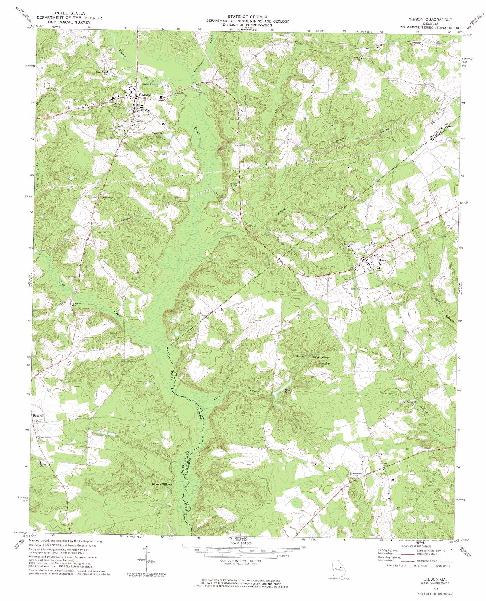
Gibson Topo Map Georgia
To zoom in, hover over the map of Gibson
USGS Topo Quad 33082b5 - 1:24,000 scale
| Topo Map Name: | Gibson |
| USGS Topo Quad ID: | 33082b5 |
| Print Size: | ca. 21 1/4" wide x 27" high |
| Southeast Coordinates: | 33.125° N latitude / 82.5° W longitude |
| Map Center Coordinates: | 33.1875° N latitude / 82.5625° W longitude |
| U.S. State: | GA |
| Filename: | o33082b5.jpg |
| Download Map JPG Image: | Gibson topo map 1:24,000 scale |
| Map Type: | Topographic |
| Topo Series: | 7.5´ |
| Map Scale: | 1:24,000 |
| Source of Map Images: | United States Geological Survey (USGS) |
| Alternate Map Versions: |
Gibson GA 1972, updated 1974 Download PDF Buy paper map Gibson GA 2011 Download PDF Buy paper map Gibson GA 2014 Download PDF Buy paper map |
1:24,000 Topo Quads surrounding Gibson
Sparta Ne |
Warrenton |
Thomson West |
Thompson East |
Harlem |
Jewell |
Beall Springs |
Bastonville |
Bowdens Pond |
Avondale |
Warthen Ne |
Mitchell |
Gibson |
Wrens |
Matthews |
Warthen |
Downs |
Grange |
Louisville |
Kellys Pond |
Sandersville |
Riddleville |
Davisboro |
Louisville South |
Old Town |
> Back to 33082a1 at 1:100,000 scale
> Back to 33082a1 at 1:250,000 scale
> Back to U.S. Topo Maps home
Gibson topo map: Gazetteer
Gibson: Dams
Haddon Pond Dam elevation 92m 301′Gibson: Populated Places
Avera elevation 137m 449′Edgehill elevation 146m 479′
Gibson elevation 106m 347′
Glovers Millpond elevation 86m 282′
Omaha Springs elevation 98m 321′
Gibson: Reservoirs
Caroline Lake elevation 95m 311′Hadden Pond elevation 92m 301′
Haddon Pond elevation 92m 301′
Gibson: Streams
Beechtree Creek elevation 86m 282′Chalk Hill Branch elevation 97m 318′
Clear Creek elevation 82m 269′
Deep Creek elevation 85m 278′
Joes Creek elevation 83m 272′
Magtail Branch elevation 91m 298′
Gibson digital topo map on disk
Buy this Gibson topo map showing relief, roads, GPS coordinates and other geographical features, as a high-resolution digital map file on DVD:
South Carolina, Western North Carolina & Northeastern Georgia
Buy digital topo maps: South Carolina, Western North Carolina & Northeastern Georgia