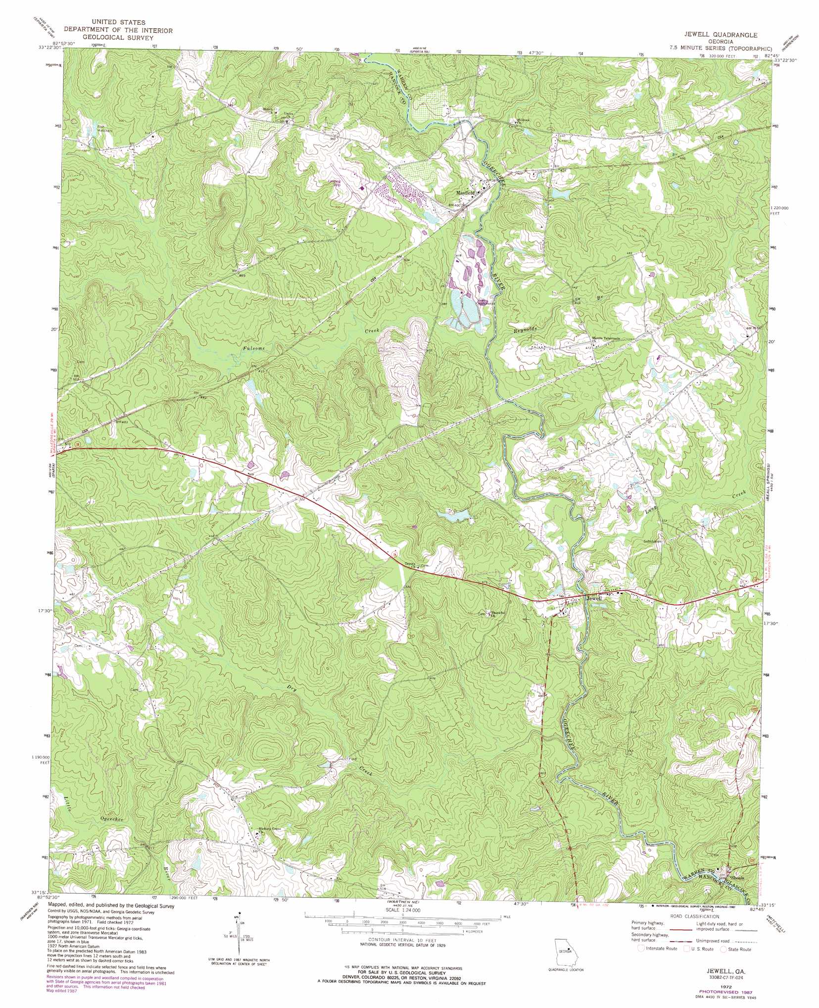
Jewell Topo Map Georgia
To zoom in, hover over the map of Jewell
USGS Topo Quad 33082c7 - 1:24,000 scale
| Topo Map Name: | Jewell |
| USGS Topo Quad ID: | 33082c7 |
| Print Size: | ca. 21 1/4" wide x 27" high |
| Southeast Coordinates: | 33.25° N latitude / 82.75° W longitude |
| Map Center Coordinates: | 33.3125° N latitude / 82.8125° W longitude |
| U.S. State: | GA |
| Filename: | o33082c7.jpg |
| Download Map JPG Image: | Jewell topo map 1:24,000 scale |
| Map Type: | Topographic |
| Topo Series: | 7.5´ |
| Map Scale: | 1:24,000 |
| Source of Map Images: | United States Geological Survey (USGS) |
| Alternate Map Versions: |
Jewell GA 1972, updated 1974 Download PDF Buy paper map Jewell GA 1972, updated 1987 Download PDF Buy paper map Jewell GA 2011 Download PDF Buy paper map Jewell GA 2014 Download PDF Buy paper map |
1:24,000 Topo Quads surrounding Jewell
Union Point |
Crawfordville |
Sharon |
Cadley |
Wrightsboro |
White Plains |
Sparta Nw |
Sparta Ne |
Warrenton |
Thomson West |
Shoulderbone |
Sparta |
Jewell |
Beall Springs |
Bastonville |
Devereux |
Warthen Nw |
Warthen Ne |
Mitchell |
Gibson |
Friendship |
Deepstep |
Warthen |
Downs |
Grange |
> Back to 33082a1 at 1:100,000 scale
> Back to 33082a1 at 1:250,000 scale
> Back to U.S. Topo Maps home
Jewell topo map: Gazetteer
Jewell: Dams
Fish Hatchery Dam elevation 123m 403′Hale Lake Dam elevation 120m 393′
Jewell: Parks
Jewel Historic District elevation 119m 390′Jewell: Populated Places
Ansley elevation 133m 436′Jewell elevation 129m 423′
Mayfield elevation 123m 403′
Jewell: Reservoirs
Dixon Pond elevation 121m 396′Fish Hatchery elevation 123m 403′
Hale Lake elevation 120m 393′
Jewell: Streams
Dry Creek elevation 99m 324′Fulsome Creek elevation 113m 370′
Long Creek elevation 105m 344′
Reynolds Branch elevation 108m 354′
Short Creek elevation 113m 370′
Jewell digital topo map on disk
Buy this Jewell topo map showing relief, roads, GPS coordinates and other geographical features, as a high-resolution digital map file on DVD:
South Carolina, Western North Carolina & Northeastern Georgia
Buy digital topo maps: South Carolina, Western North Carolina & Northeastern Georgia