Sparta Topo Map Georgia
To zoom in, hover over the map of Sparta
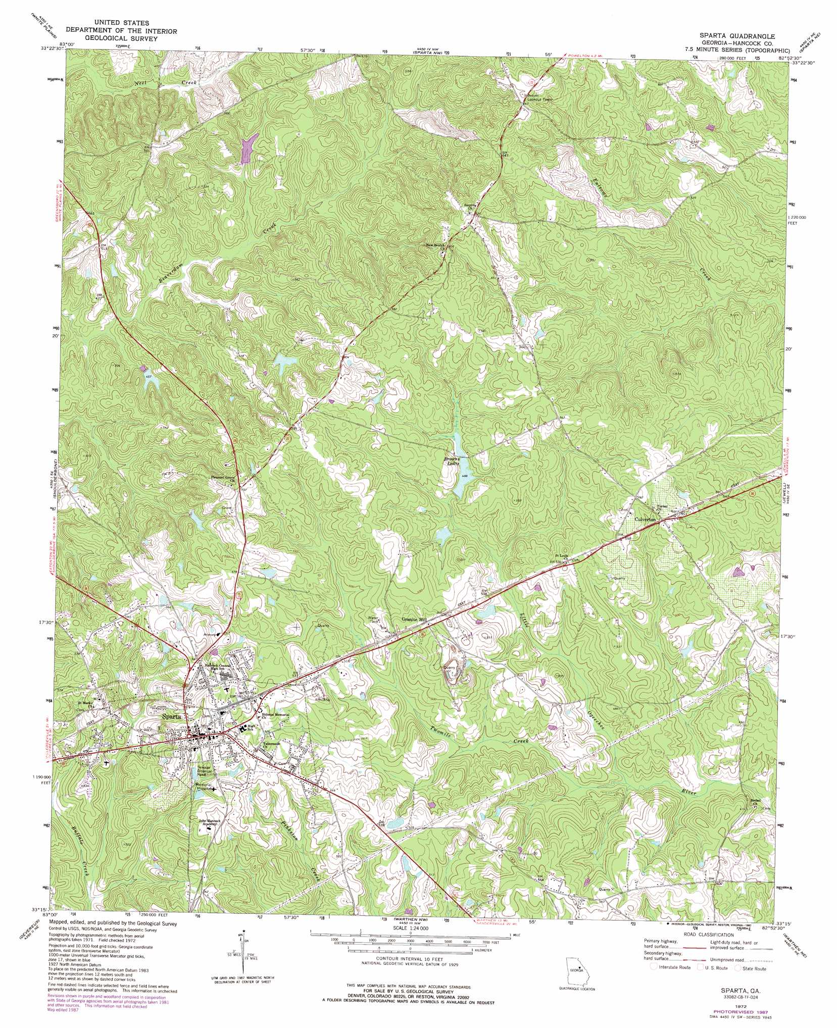
USGS Topo Quad 33082c8 - 1:24,000 scale
| Topo Map Name: | Sparta |
| USGS Topo Quad ID: | 33082c8 |
| Print Size: | ca. 21 1/4" wide x 27" high |
| Southeast Coordinates: | 33.25° N latitude / 82.875° W longitude |
| Map Center Coordinates: | 33.3125° N latitude / 82.9375° W longitude |
| U.S. State: | GA |
| Filename: | o33082c8.jpg |
| Download Map JPG Image: | Sparta topo map 1:24,000 scale |
| Map Type: | Topographic |
| Topo Series: | 7.5´ |
| Map Scale: | 1:24,000 |
| Source of Map Images: | United States Geological Survey (USGS) |
| Alternate Map Versions: |
Sparta GA 1972, updated 1975 Download PDF Buy paper map Sparta GA 1972, updated 1987 Download PDF Buy paper map Sparta GA 2011 Download PDF Buy paper map Sparta GA 2014 Download PDF Buy paper map |
1:24,000 Topo Quads surrounding Sparta
Greensboro |
Union Point |
Crawfordville |
Sharon |
Cadley |
Liberty |
White Plains |
Sparta Nw |
Sparta Ne |
Warrenton |
Rockville |
Shoulderbone |
Sparta |
Jewell |
Beall Springs |
Lake Sinclair East |
Devereux |
Warthen Nw |
Warthen Ne |
Mitchell |
Milledgeville |
Friendship |
Deepstep |
Warthen |
Downs |
> Back to 33082a1 at 1:100,000 scale
> Back to 33082a1 at 1:250,000 scale
> Back to U.S. Topo Maps home
Sparta topo map: Gazetteer
Sparta: Airports
Hancock Memorial Hospital Heliport elevation 164m 538′Sparta: Dams
Armstrong Cork Lake Dam elevation 143m 469′Brown Lake Dam elevation 157m 515′
Browns Lake Dam elevation 149m 488′
Coleman Lake Dam elevation 148m 485′
Sparta: Lakes
Browns Lakes elevation 150m 492′Sparta: Parks
Sparta Historic District elevation 171m 561′Sparta: Populated Places
Culverton elevation 170m 557′Sparta elevation 171m 561′
Sunshine (historical) elevation 149m 488′
Sparta: Reservoirs
Armstrong Lake elevation 143m 469′Brown Lake elevation 157m 515′
Browns Lake elevation 149m 488′
Coleman Lake elevation 148m 485′
Sparta: Streams
Twomile Creek elevation 130m 426′Sparta: Summits
Granite Hill elevation 159m 521′Sparta digital topo map on disk
Buy this Sparta topo map showing relief, roads, GPS coordinates and other geographical features, as a high-resolution digital map file on DVD:
South Carolina, Western North Carolina & Northeastern Georgia
Buy digital topo maps: South Carolina, Western North Carolina & Northeastern Georgia