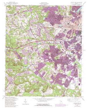
Augusta West Topo Map Georgia
To zoom in, hover over the map of Augusta West
USGS Topo Quad 33082d1 - 1:24,000 scale
| Topo Map Name: | Augusta West |
| USGS Topo Quad ID: | 33082d1 |
| Print Size: | ca. 21 1/4" wide x 27" high |
| Southeast Coordinates: | 33.375° N latitude / 82° W longitude |
| Map Center Coordinates: | 33.4375° N latitude / 82.0625° W longitude |
| U.S. State: | GA |
| Filename: | o33082d1.jpg |
| Download Map JPG Image: | Augusta West topo map 1:24,000 scale |
| Map Type: | Topographic |
| Topo Series: | 7.5´ |
| Map Scale: | 1:24,000 |
| Source of Map Images: | United States Geological Survey (USGS) |
| Alternate Map Versions: |
Augusta West GA 1950 Download PDF Buy paper map Augusta West GA 1957, updated 1960 Download PDF Buy paper map Augusta West GA 1957, updated 1973 Download PDF Buy paper map Augusta West GA 1957, updated 1981 Download PDF Buy paper map Augusta West GA 1957, updated 1984 Download PDF Buy paper map Augusta West GA 2011 Download PDF Buy paper map Augusta West GA 2014 Download PDF Buy paper map |
1:24,000 Topo Quads surrounding Augusta West
> Back to 33082a1 at 1:100,000 scale
> Back to 33082a1 at 1:250,000 scale
> Back to U.S. Topo Maps home
Augusta West topo map: Gazetteer
Augusta West: Airports
Daniel Field elevation 125m 410′Doctors Hospital Heliport elevation 114m 374′
Dwight David Eisenhower Army Medical Center Heliport elevation 132m 433′
Augusta West: Crossings
Exit 64 elevation 100m 328′Augusta West: Dams
Fort Gordon Reservoir Dam elevation 77m 252′Lake Aumond Dam elevation 80m 262′
Lombards Mill Pond Dam elevation 65m 213′
Rosedale Lake Dam elevation 68m 223′
Soil Erosion Lake Dam elevation 111m 364′
Augusta West: Parks
Highland Park elevation 128m 419′Julian Smith Park elevation 47m 154′
King Park elevation 104m 341′
Pendleton King Park elevation 57m 187′
Reynolds Park elevation 116m 380′
Summerville Historic District elevation 122m 400′
Tanglewood Park elevation 110m 360′
Washington Monument elevation 45m 147′
Augusta West: Populated Places
Adams (historical) elevation 48m 157′Adventure (historical) elevation 54m 177′
Arrow Head elevation 120m 393′
Barton Village elevation 125m 410′
Bayvale elevation 57m 187′
Bel Air Heights elevation 135m 442′
Belair elevation 93m 305′
Bellemead elevation 76m 249′
Berckman Hills elevation 62m 203′
Berckman Villas elevation 70m 229′
Bridgeport elevation 127m 416′
Brynwood elevation 75m 246′
Burch Grant elevation 85m 278′
Butler Estates elevation 42m 137′
Butler Manor elevation 89m 291′
Carmell Mobile Home Park elevation 69m 226′
Carriage Court elevation 121m 396′
Christa elevation 79m 259′
Colony Park elevation 67m 219′
Conifer Place elevation 114m 374′
Country Club Hills elevation 70m 229′
Davison elevation 57m 187′
Duran Mobile Home Park elevation 61m 200′
Edenwood elevation 53m 173′
Fairington elevation 144m 472′
Fairvale elevation 49m 160′
Fleming Heights elevation 100m 328′
Forest Acres elevation 49m 160′
Forest Estates elevation 92m 301′
Forest Hills elevation 98m 321′
Gaskins Mobile Home Park elevation 64m 209′
Georgetown Estates elevation 145m 475′
Glenn Hills elevation 130m 426′
Golden Terrace elevation 110m 360′
Gordon Terrace elevation 139m 456′
Green Meadows Estates elevation 90m 295′
Greenbrier elevation 100m 328′
Hidden Hills elevation 142m 465′
Highgate elevation 91m 298′
Highland Park elevation 105m 344′
Hillside Park elevation 68m 223′
Kendan Park elevation 45m 147′
King Estates elevation 91m 298′
Kingston elevation 104m 341′
Laurel Hill elevation 138m 452′
Lumpkin Park elevation 98m 321′
Mayfair elevation 121m 396′
McNair Terrace elevation 138m 452′
Meadowbrook elevation 63m 206′
Meadowlark elevation 68m 223′
Monticello elevation 65m 213′
Mount Vernon elevation 77m 252′
Murphy Mobile Home Park elevation 125m 410′
Murray Hills elevation 93m 305′
Neco elevation 46m 150′
Northview elevation 52m 170′
Norton Acres elevation 70m 229′
Oglethorpe Homes elevation 52m 170′
Oklahoma Hills elevation 85m 278′
Olmstead Homes elevation 56m 183′
Pepperidge elevation 71m 232′
Pine Heights elevation 43m 141′
Plantation Acres Mobile Home Park elevation 107m 351′
Quail Hollow elevation 132m 433′
Raes (historical) elevation 75m 246′
Richmond Gardens elevation 62m 203′
Richmond Hills elevation 96m 314′
Ridgewood elevation 112m 367′
Rockbrook elevation 80m 262′
Rolling Meadows elevation 72m 236′
Salem elevation 60m 196′
Sand Ridge elevation 123m 403′
Sherwood elevation 49m 160′
Shiloh Terrace elevation 86m 282′
Silvercrest elevation 70m 229′
Southgate Village elevation 46m 150′
Southlands elevation 42m 137′
Southwick elevation 116m 380′
Spanish Trace elevation 133m 436′
Springfield elevation 97m 318′
Summerville elevation 122m 400′
Tanglewood elevation 106m 347′
Terrace Manor elevation 123m 403′
Thomas Woods elevation 103m 337′
Twin Oaks elevation 79m 259′
Valley Forge elevation 65m 213′
Valley Park elevation 97m 318′
Waverly elevation 75m 246′
Westwick elevation 95m 311′
Westwood elevation 116m 380′
Wheless elevation 61m 200′
Windsor Spring elevation 125m 410′
Windsor Springs Estates elevation 49m 160′
Windy Ridge Estates elevation 137m 449′
Woodlake elevation 81m 265′
Augusta West: Reservoirs
Adams Lake elevation 83m 272′Boardmans Pond elevation 84m 275′
Carmichael Pond elevation 43m 141′
Fort Gordon Reservoir elevation 77m 252′
Garden Springs Lake elevation 94m 308′
Kissing Bower Lake elevation 51m 167′
Lake Aumond elevation 80m 262′
Lombard Millpond elevation 65m 213′
Lombard Pond elevation 42m 137′
Rosebud Lake elevation 66m 216′
Rosedale Pond elevation 68m 223′
Soil Erosion Lake elevation 111m 364′
Wades Lake (historical) elevation 80m 262′
Wilkinsons Pond elevation 50m 164′
Augusta West: Springs
Windsor Spring elevation 108m 354′Augusta West: Streams
Cranes Creek elevation 67m 219′Raes Creek elevation 48m 157′
Augusta West digital topo map on disk
Buy this Augusta West topo map showing relief, roads, GPS coordinates and other geographical features, as a high-resolution digital map file on DVD:
South Carolina, Western North Carolina & Northeastern Georgia
Buy digital topo maps: South Carolina, Western North Carolina & Northeastern Georgia


