Grovetown Topo Map Georgia
To zoom in, hover over the map of Grovetown
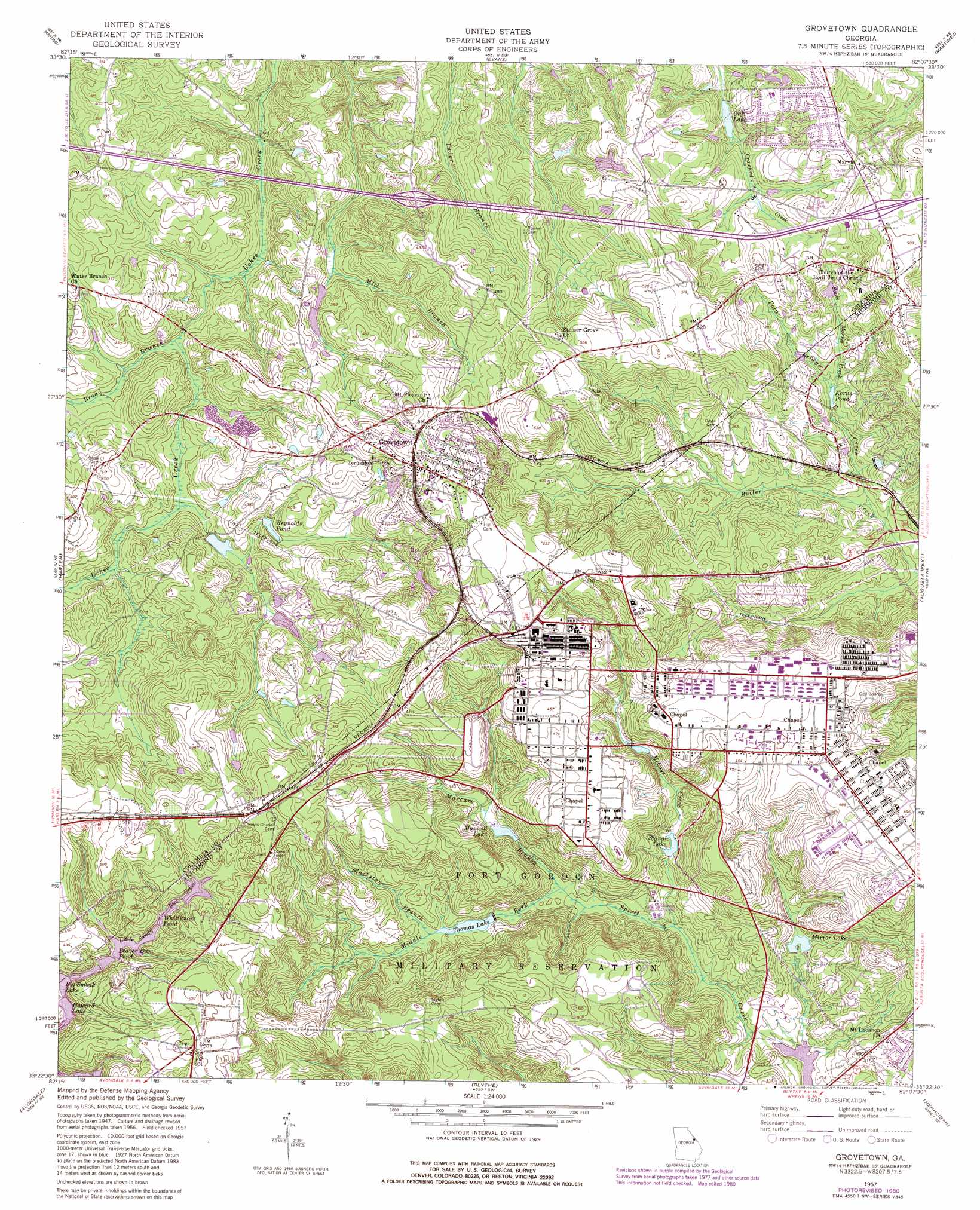
USGS Topo Quad 33082d2 - 1:24,000 scale
| Topo Map Name: | Grovetown |
| USGS Topo Quad ID: | 33082d2 |
| Print Size: | ca. 21 1/4" wide x 27" high |
| Southeast Coordinates: | 33.375° N latitude / 82.125° W longitude |
| Map Center Coordinates: | 33.4375° N latitude / 82.1875° W longitude |
| U.S. State: | GA |
| Filename: | o33082d2.jpg |
| Download Map JPG Image: | Grovetown topo map 1:24,000 scale |
| Map Type: | Topographic |
| Topo Series: | 7.5´ |
| Map Scale: | 1:24,000 |
| Source of Map Images: | United States Geological Survey (USGS) |
| Alternate Map Versions: |
Grovetown GA 1950 Download PDF Buy paper map Grovetown GA 1957, updated 1973 Download PDF Buy paper map Grovetown GA 1957, updated 1980 Download PDF Buy paper map Grovetown GA 1957, updated 1981 Download PDF Buy paper map Grovetown GA 2011 Download PDF Buy paper map Grovetown GA 2014 Download PDF Buy paper map |
1:24,000 Topo Quads surrounding Grovetown
Woodlawn |
Leah |
Clarks Hill |
Colliers |
Ropers Crossroads |
Winfield |
Appling |
Evans |
Martinez |
North Augusta |
Thompson East |
Harlem |
Grovetown |
Augusta West |
Augusta East |
Bowdens Pond |
Avondale |
Blythe |
Hephzibah |
Mechanic Hill |
Wrens |
Matthews |
Keysville |
Storys Millpond |
Mcbean |
> Back to 33082a1 at 1:100,000 scale
> Back to 33082a1 at 1:250,000 scale
> Back to U.S. Topo Maps home
Grovetown topo map: Gazetteer
Grovetown: Airports
Flying J Airstrip elevation 132m 433′Grovetown: Crossings
Exit 62 elevation 128m 419′Exit 63 elevation 153m 501′
Grovetown: Dams
Baldwins Lake Dam elevation 124m 406′Cawley Lake Dam elevation 134m 439′
Helen Huffman Lake Dam elevation 128m 419′
Lower Hitts Lake Dam elevation 115m 377′
Oak Lake Dam elevation 99m 324′
Upper Hitt Lake Dam elevation 110m 360′
Wells Lake Dam elevation 93m 305′
Grovetown: Populated Places
Avery Landing elevation 130m 426′Belglade elevation 122m 400′
Blanchard Park elevation 139m 456′
Buffalo Ranch elevation 139m 456′
Forrest (historical) elevation 156m 511′
Fort Gordon elevation 143m 469′
Grovetown elevation 146m 479′
Hill and Dale Trailer Park elevation 129m 423′
Kensington elevation 116m 380′
Kettle Creek elevation 151m 495′
Lake Royal elevation 121m 396′
Lewiston Downs elevation 110m 360′
Maple Creek elevation 140m 459′
Oak Lake elevation 111m 364′
Olive Terrace elevation 143m 469′
Quail Creek elevation 128m 419′
Ridge Crossing elevation 140m 459′
Ridge Point elevation 149m 488′
Silver Maple Ridge elevation 134m 439′
Smithwick elevation 147m 482′
Sugarcreek elevation 115m 377′
Tower Pines elevation 112m 367′
Westmont elevation 137m 449′
Windy Acres Trailer Park elevation 124m 406′
Grovetown: Reservoirs
Baldwins Lake elevation 124m 406′Beaver Dam Pond elevation 117m 383′
Big Smoak Lake elevation 112m 367′
Cawley Lake elevation 134m 439′
Helen Huffman Lake elevation 128m 419′
Howard Lake elevation 111m 364′
Kerns Pond elevation 93m 305′
Lower Hitts Lake elevation 115m 377′
Maxwell Lake elevation 95m 311′
Mirror Lake elevation 88m 288′
Oak Lake elevation 99m 324′
Reynolds Pond elevation 106m 347′
Signal Lake elevation 91m 298′
Sunrise Lake elevation 111m 364′
Thomas Lake elevation 96m 314′
Upper Hitt Lake elevation 110m 360′
Wells Lake elevation 93m 305′
Whittimore Pond elevation 121m 396′
Wilkerson Lake elevation 107m 351′
Grovetown: Streams
Blackstone Branch elevation 96m 314′Broad Branch elevation 86m 282′
Horn Creek elevation 93m 305′
Marcum Branch elevation 88m 288′
McCoys Creek elevation 81m 265′
Middle Fork Spirit Creek elevation 88m 288′
Polar Bridge Creek elevation 84m 275′
Sadie Morris Creek elevation 96m 314′
Grovetown digital topo map on disk
Buy this Grovetown topo map showing relief, roads, GPS coordinates and other geographical features, as a high-resolution digital map file on DVD:
South Carolina, Western North Carolina & Northeastern Georgia
Buy digital topo maps: South Carolina, Western North Carolina & Northeastern Georgia