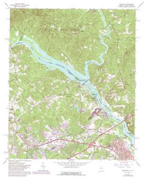
Martinez Topo Map Georgia
To zoom in, hover over the map of Martinez
USGS Topo Quad 33082e1 - 1:24,000 scale
| Topo Map Name: | Martinez |
| USGS Topo Quad ID: | 33082e1 |
| Print Size: | ca. 21 1/4" wide x 27" high |
| Southeast Coordinates: | 33.5° N latitude / 82° W longitude |
| Map Center Coordinates: | 33.5625° N latitude / 82.0625° W longitude |
| U.S. States: | GA, SC |
| Filename: | o33082e1.jpg |
| Download Map JPG Image: | Martinez topo map 1:24,000 scale |
| Map Type: | Topographic |
| Topo Series: | 7.5´ |
| Map Scale: | 1:24,000 |
| Source of Map Images: | United States Geological Survey (USGS) |
| Alternate Map Versions: |
Martinez GA 1964, updated 1966 Download PDF Buy paper map Martinez GA 1964, updated 1973 Download PDF Buy paper map Martinez GA 1964, updated 1981 Download PDF Buy paper map Martinez GA 2011 Download PDF Buy paper map Martinez GA 2014 Download PDF Buy paper map |
| FStopo: | US Forest Service topo Martinez is available: Download FStopo PDF Download FStopo TIF |
1:24,000 Topo Quads surrounding Martinez
> Back to 33082e1 at 1:100,000 scale
> Back to 33082a1 at 1:250,000 scale
> Back to U.S. Topo Maps home
Martinez topo map: Gazetteer
Martinez: Bridges
Furys Ferry Bridge elevation 57m 187′Furys Ferry Bridge elevation 57m 187′
Shaw and McKee Bridge elevation 57m 187′
Martinez: Channels
Four Mile Reach elevation 57m 187′Four Mile Reach elevation 57m 187′
Martinez: Crossings
Exit 65 elevation 81m 265′Furys Ferry (historical) elevation 57m 187′
Furys Ferry (historical) elevation 57m 187′
Shaw and McKie Ferry (historical) elevation 57m 187′
Martinez: Dams
Augusta City Lock and Dam elevation 47m 154′Augusta City Lock and Dam elevation 47m 154′
Bowen Pond Dam elevation 56m 183′
Mullens Lake Dam elevation 82m 269′
Spring Lake Dam elevation 96m 314′
Stevens Creek Dam elevation 47m 154′
Stevens Creek Dam elevation 53m 173′
Martinez: Islands
Griffin Island (historical) elevation 57m 187′Griffin Island (historical) elevation 57m 187′
Ninety Nine Islands elevation 48m 157′
Martinez: Lakes
Johns Pond elevation 101m 331′Martinez: Populated Places
Avondale elevation 104m 341′Beverly Heights elevation 89m 291′
Bonair elevation 85m 278′
Bonaire Heights elevation 115m 377′
Briarwood elevation 110m 360′
Bristol Wood elevation 86m 282′
Brookfield West elevation 102m 334′
Cambridge elevation 80m 262′
Candlewood Crossing elevation 110m 360′
Casa Bella elevation 115m 377′
Casa Linda elevation 115m 377′
Columbia Heights elevation 121m 396′
Creek View elevation 97m 318′
Crofton elevation 90m 295′
Dorchester elevation 80m 262′
Edgewood elevation 118m 387′
Evans Mill elevation 110m 360′
Farmington elevation 120m 393′
Fernbrook elevation 100m 328′
Forest Creek elevation 66m 216′
Forest Park elevation 53m 173′
Foxhall elevation 98m 321′
Gaines Court elevation 56m 183′
Holiday Park elevation 109m 357′
Huntington elevation 102m 334′
Jamaica Estates elevation 103m 337′
Jushua Tree Villas elevation 102m 334′
Kennelworth elevation 72m 236′
Lamkin elevation 119m 390′
Lenoir (historical) elevation 86m 282′
Lulaville elevation 109m 357′
Martinez elevation 110m 360′
Mayo elevation 114m 374′
Maysville (historical) elevation 95m 311′
Memory Park elevation 113m 370′
Montclair elevation 99m 324′
Morgana elevation 98m 321′
National Hills elevation 67m 219′
New Richmond (historical) elevation 45m 147′
Petersburg Station elevation 106m 347′
Phillips Estates elevation 119m 390′
Poverty Hill elevation 111m 364′
Shenandoah elevation 116m 380′
Shenandoah Woods elevation 101m 331′
Snead elevation 93m 305′
Spring Lakes elevation 110m 360′
Stallings Place elevation 68m 223′
Sterling Heights elevation 92m 301′
Stevens Creek elevation 79m 259′
Stevens Creek West elevation 104m 341′
Stevens Pointe elevation 68m 223′
Sweetbriar elevation 114m 374′
Village at Watervale elevation 83m 272′
Village West elevation 93m 305′
Watervale elevation 94m 308′
West Hampton elevation 98m 321′
West Hills elevation 82m 269′
West Lynne elevation 126m 413′
Westlake elevation 69m 226′
Westport elevation 82m 269′
Westwood elevation 113m 370′
Windsor Court elevation 75m 246′
Windsor Forest elevation 59m 193′
Woodland elevation 122m 400′
Wynngate elevation 106m 347′
Martinez: Post Offices
Martinez Post Office elevation 106m 347′Martinez: Reservoirs
Bowen Pond elevation 56m 183′Marshall Pond elevation 94m 308′
Mullens Lake elevation 82m 269′
Spring Lake elevation 96m 314′
Stewarts Ponds elevation 93m 305′
Martinez: Streams
Anderson Branch elevation 58m 190′Bussy Creek elevation 57m 187′
Deep Step Branch elevation 57m 187′
Fox Creek elevation 44m 144′
Hardy Branch elevation 57m 187′
Jones Creek elevation 57m 187′
Little River elevation 63m 206′
Maulden Branch elevation 57m 187′
Reed Creek elevation 48m 157′
Rock Creek elevation 48m 157′
Stevens Creek elevation 57m 187′
Sweetwater Branch elevation 57m 187′
Martinez: Summits
Poverty Hill elevation 130m 426′Martinez digital topo map on disk
Buy this Martinez topo map showing relief, roads, GPS coordinates and other geographical features, as a high-resolution digital map file on DVD:
South Carolina, Western North Carolina & Northeastern Georgia
Buy digital topo maps: South Carolina, Western North Carolina & Northeastern Georgia


