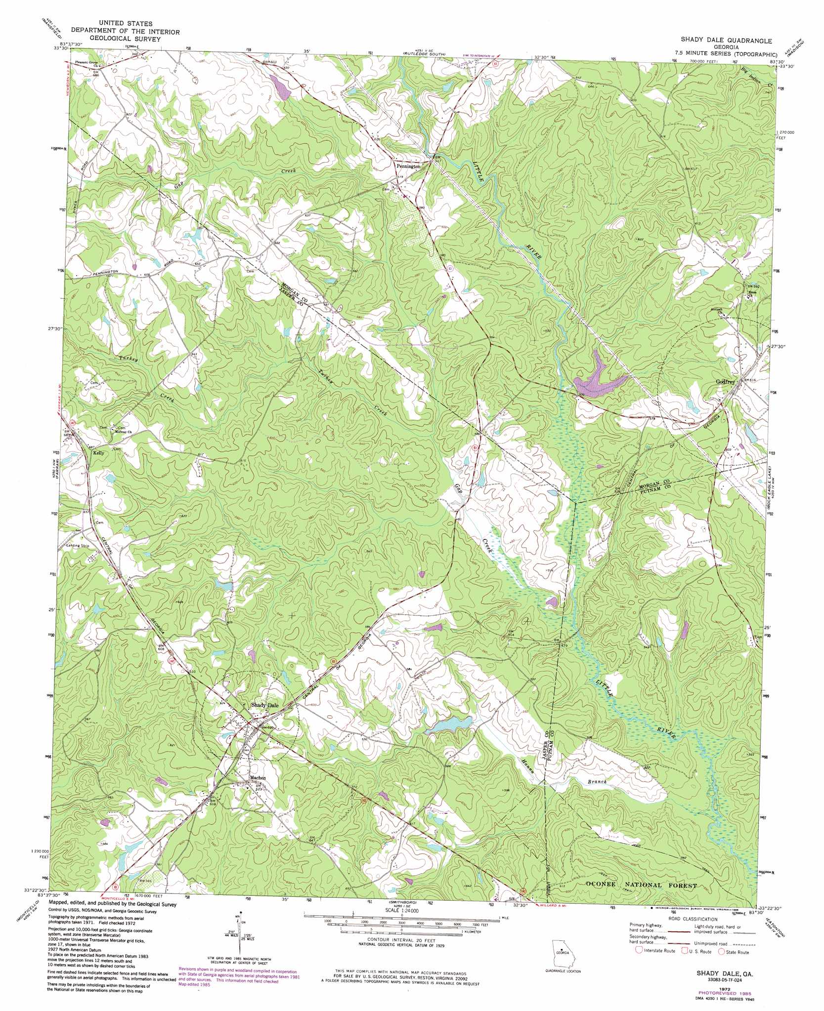
Shady Dale Topo Map Georgia
To zoom in, hover over the map of Shady Dale
USGS Topo Quad 33083d5 - 1:24,000 scale
| Topo Map Name: | Shady Dale |
| USGS Topo Quad ID: | 33083d5 |
| Print Size: | ca. 21 1/4" wide x 27" high |
| Southeast Coordinates: | 33.375° N latitude / 83.5° W longitude |
| Map Center Coordinates: | 33.4375° N latitude / 83.5625° W longitude |
| U.S. State: | GA |
| Filename: | o33083d5.jpg |
| Download Map JPG Image: | Shady Dale topo map 1:24,000 scale |
| Map Type: | Topographic |
| Topo Series: | 7.5´ |
| Map Scale: | 1:24,000 |
| Source of Map Images: | United States Geological Survey (USGS) |
| Alternate Map Versions: |
Shady Dale GA 1972, updated 1974 Download PDF Buy paper map Shady Dale GA 1972, updated 1985 Download PDF Buy paper map Shady Dale GA 2011 Download PDF Buy paper map Shady Dale GA 2014 Download PDF Buy paper map |
| FStopo: | US Forest Service topo Shady Dale is available: Download FStopo PDF Download FStopo TIF |
1:24,000 Topo Quads surrounding Shady Dale
Jersey |
Social Circle |
Rutledge North |
Apalachee |
Greshamville |
Covington |
Mansfield |
Rutledge South |
Madison |
Buckhead |
Stewart |
Farrar |
Shady Dale |
Rock Eagle Lake |
Harmony |
Lloyd Shoals Dam |
Monticello |
Smithboro |
Eatonton |
Meda |
Berner |
Hillsboro |
Stanfordville |
Resseaus Crossroads |
Lake Sinclair West |
> Back to 33083a1 at 1:100,000 scale
> Back to 33082a1 at 1:250,000 scale
> Back to U.S. Topo Maps home
Shady Dale topo map: Gazetteer
Shady Dale: Bridges
Mobley Bridge elevation 140m 459′Shady Dale: Dams
Lynch Dam elevation 145m 475′McComb Lake Dam elevation 182m 597′
Vason Dam elevation 139m 456′
Shady Dale: Populated Places
Athon (historical) elevation 179m 587′Godfrey elevation 187m 613′
Hearnville (historical) elevation 185m 606′
Kelly elevation 208m 682′
Machen elevation 190m 623′
Pennington elevation 157m 515′
Shady Dale elevation 190m 623′
Shady Dale: Reservoirs
Lynch Lake elevation 145m 475′McComb Lake elevation 182m 597′
Vason Lake elevation 139m 456′
Shady Dale: Streams
Gap Creek elevation 132m 433′Hanna Branch elevation 127m 416′
Hone Branch elevation 132m 433′
Turkey Creek elevation 143m 469′
Shady Dale digital topo map on disk
Buy this Shady Dale topo map showing relief, roads, GPS coordinates and other geographical features, as a high-resolution digital map file on DVD:
South Carolina, Western North Carolina & Northeastern Georgia
Buy digital topo maps: South Carolina, Western North Carolina & Northeastern Georgia