Apalachee Topo Map Georgia
To zoom in, hover over the map of Apalachee
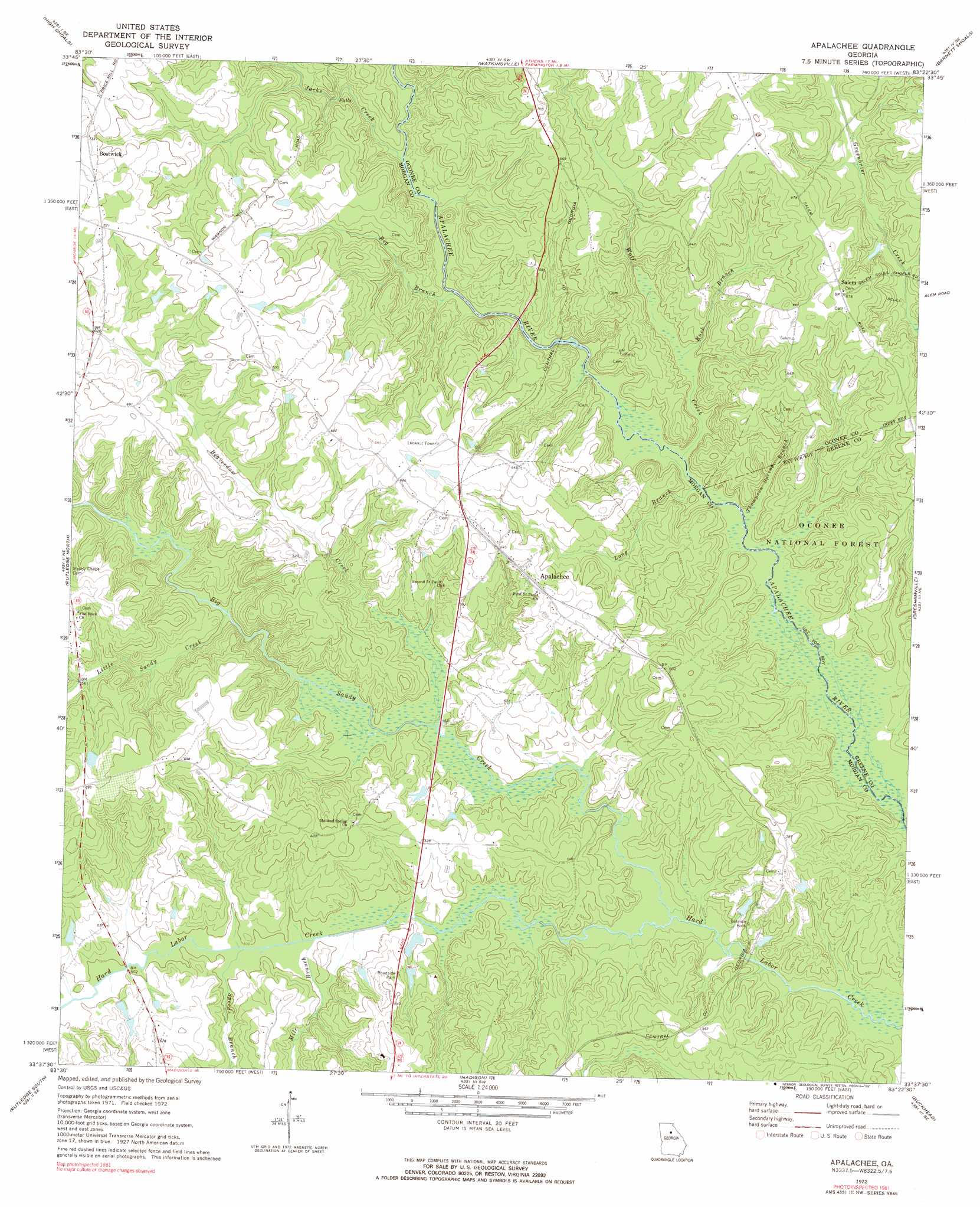
USGS Topo Quad 33083f4 - 1:24,000 scale
| Topo Map Name: | Apalachee |
| USGS Topo Quad ID: | 33083f4 |
| Print Size: | ca. 21 1/4" wide x 27" high |
| Southeast Coordinates: | 33.625° N latitude / 83.375° W longitude |
| Map Center Coordinates: | 33.6875° N latitude / 83.4375° W longitude |
| U.S. State: | GA |
| Filename: | o33083f4.jpg |
| Download Map JPG Image: | Apalachee topo map 1:24,000 scale |
| Map Type: | Topographic |
| Topo Series: | 7.5´ |
| Map Scale: | 1:24,000 |
| Source of Map Images: | United States Geological Survey (USGS) |
| Alternate Map Versions: |
Apalachee GA 1972, updated 1974 Download PDF Buy paper map Apalachee GA 1972, updated 1991 Download PDF Buy paper map Apalachee GA 2011 Download PDF Buy paper map Apalachee GA 2014 Download PDF Buy paper map |
| FStopo: | US Forest Service topo Apalachee is available: Download FStopo PDF Download FStopo TIF |
1:24,000 Topo Quads surrounding Apalachee
Winder South |
Statham |
Athens West |
Athens East |
Crawford |
Monroe |
High Shoals |
Watkinsville |
Barnett Shoals |
Maxeys |
Social Circle |
Rutledge North |
Apalachee |
Greshamville |
Penfield |
Mansfield |
Rutledge South |
Madison |
Buckhead |
Greensboro |
Farrar |
Shady Dale |
Rock Eagle Lake |
Harmony |
Liberty |
> Back to 33083e1 at 1:100,000 scale
> Back to 33082a1 at 1:250,000 scale
> Back to U.S. Topo Maps home
Apalachee topo map: Gazetteer
Apalachee: Bridges
Boons Bridge elevation 135m 442′Heads Mill Bridge (historical) elevation 146m 479′
Trimble Bridge elevation 136m 446′
Apalachee: Dams
Brown Lake Dam elevation 150m 492′Chambers Dam elevation 162m 531′
Hemperly Dam elevation 157m 515′
Nolan Lake Dam elevation 197m 646′
Paper Dam elevation 142m 465′
Robins Dam elevation 150m 492′
Youngblood Dam elevation 162m 531′
Apalachee: Lakes
Tap Lake elevation 200m 656′Apalachee: Pillars
Balance Rock elevation 160m 524′Apalachee: Populated Places
Apalachee elevation 196m 643′Nolans Store elevation 209m 685′
Salem elevation 204m 669′
Shields (historical) elevation 180m 590′
Turpin (historical) elevation 194m 636′
Apalachee: Reservoirs
Brown Lake elevation 150m 492′Chambers Lake elevation 162m 531′
Nolan Lake elevation 197m 646′
Paper Lake elevation 142m 465′
Robins Lake elevation 150m 492′
Youngblood Lake elevation 162m 531′
Apalachee: Streams
Beaverdam Creek elevation 146m 479′Big Branch elevation 153m 501′
Big Sandy Creek elevation 136m 446′
Buck Branch elevation 144m 472′
Jacks Creek elevation 156m 511′
Little Sandy Creek elevation 151m 495′
Long Branch elevation 145m 475′
Mile Branch elevation 150m 492′
Speeds Branch elevation 149m 488′
Thompson Spring Branch elevation 143m 469′
Wolf Creek elevation 144m 472′
Apalachee digital topo map on disk
Buy this Apalachee topo map showing relief, roads, GPS coordinates and other geographical features, as a high-resolution digital map file on DVD:
South Carolina, Western North Carolina & Northeastern Georgia
Buy digital topo maps: South Carolina, Western North Carolina & Northeastern Georgia