Jersey Topo Map Georgia
To zoom in, hover over the map of Jersey
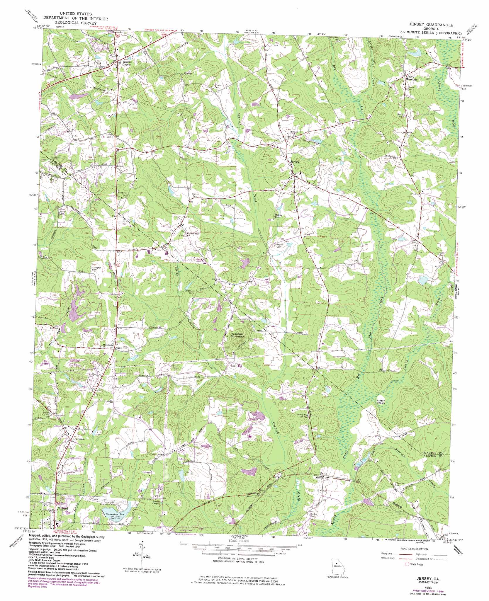
USGS Topo Quad 33083f7 - 1:24,000 scale
| Topo Map Name: | Jersey |
| USGS Topo Quad ID: | 33083f7 |
| Print Size: | ca. 21 1/4" wide x 27" high |
| Southeast Coordinates: | 33.625° N latitude / 83.75° W longitude |
| Map Center Coordinates: | 33.6875° N latitude / 83.8125° W longitude |
| U.S. State: | GA |
| Filename: | o33083f7.jpg |
| Download Map JPG Image: | Jersey topo map 1:24,000 scale |
| Map Type: | Topographic |
| Topo Series: | 7.5´ |
| Map Scale: | 1:24,000 |
| Source of Map Images: | United States Geological Survey (USGS) |
| Alternate Map Versions: |
Jersey GA 1964, updated 1966 Download PDF Buy paper map Jersey GA 1964, updated 1988 Download PDF Buy paper map Jersey GA 2011 Download PDF Buy paper map Jersey GA 2014 Download PDF Buy paper map |
1:24,000 Topo Quads surrounding Jersey
Luxomni |
Lawrenceville |
Bold Springs |
Winder South |
Statham |
Snellville |
Loganville |
Between |
Monroe |
High Shoals |
Conyers |
Milstead |
Jersey |
Social Circle |
Rutledge North |
Kelleytown |
Porterdale |
Covington |
Mansfield |
Rutledge South |
Ola |
Worthville |
Stewart |
Farrar |
Shady Dale |
> Back to 33083e1 at 1:100,000 scale
> Back to 33082a1 at 1:250,000 scale
> Back to U.S. Topo Maps home
Jersey topo map: Gazetteer
Jersey: Airports
Covington Municipal Airport elevation 238m 780′Poole Farm Airport elevation 249m 816′
Sunset Strip elevation 232m 761′
Jersey: Bars
Hinton Shoals elevation 201m 659′Jersey: Dams
Calhoun Dam elevation 260m 853′Covington Reservoir Dam elevation 232m 761′
Hodges Dam elevation 220m 721′
Lower Williams Lake Dam elevation 205m 672′
Shephard Dam elevation 222m 728′
Stone Lea Lake Dam elevation 230m 754′
Stone Lea Lake Dam elevation 238m 780′
Upper Williams Lake Dam elevation 212m 695′
Wallace Lake Dam elevation 209m 685′
Whitley Dam elevation 212m 695′
Jersey: Populated Places
Airport Grove elevation 253m 830′Alcovy elevation 219m 718′
Alcovy Mountain elevation 238m 780′
Briarpatch elevation 244m 800′
Cedar Ridge elevation 231m 757′
Dialtown elevation 245m 803′
Essex Village elevation 247m 810′
Flint Hill elevation 250m 820′
Greenwood Acres elevation 249m 816′
Hazelbrand Acres elevation 216m 708′
Jersey elevation 255m 836′
Meadow View elevation 247m 810′
Murphy Hills elevation 238m 780′
Pine Top Hill elevation 253m 830′
River Cove elevation 229m 751′
Stone Lea elevation 245m 803′
Walnut Grove elevation 281m 921′
Jersey: Post Offices
Walnut Grove Post Office elevation 281m 921′Jersey: Reservoirs
Calhoun Lake elevation 260m 853′Cornish Creek Reservoir elevation 207m 679′
Covington Reservoir elevation 232m 761′
Hodges Lake elevation 220m 721′
Lower Williams Lake elevation 205m 672′
Shephard Lake elevation 222m 728′
Stone Lea Lake elevation 238m 780′
Upper Williams Lake elevation 212m 695′
Wallace Lake elevation 209m 685′
Whitley Lake elevation 212m 695′
Jersey: Streams
Big Flat Creek elevation 200m 656′Little Cornish Creek elevation 204m 669′
Little Flat Creek elevation 212m 695′
Mountain Creek elevation 211m 692′
Naked Creek elevation 206m 675′
Richland Creek elevation 206m 675′
Strouds Creek elevation 200m 656′
Jersey: Summits
Cornish Mountain elevation 284m 931′Jersey digital topo map on disk
Buy this Jersey topo map showing relief, roads, GPS coordinates and other geographical features, as a high-resolution digital map file on DVD:
South Carolina, Western North Carolina & Northeastern Georgia
Buy digital topo maps: South Carolina, Western North Carolina & Northeastern Georgia