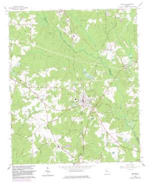
Senoia Topo Map Georgia
To zoom in, hover over the map of Senoia
USGS Topo Quad 33084c5 - 1:24,000 scale
| Topo Map Name: | Senoia |
| USGS Topo Quad ID: | 33084c5 |
| Print Size: | ca. 21 1/4" wide x 27" high |
| Southeast Coordinates: | 33.25° N latitude / 84.5° W longitude |
| Map Center Coordinates: | 33.3125° N latitude / 84.5625° W longitude |
| U.S. State: | GA |
| Filename: | o33084c5.jpg |
| Download Map JPG Image: | Senoia topo map 1:24,000 scale |
| Map Type: | Topographic |
| Topo Series: | 7.5´ |
| Map Scale: | 1:24,000 |
| Source of Map Images: | United States Geological Survey (USGS) |
| Alternate Map Versions: |
Senoia GA 1965, updated 1967 Download PDF Buy paper map Senoia GA 1965, updated 1983 Download PDF Buy paper map Senoia GA 2011 Download PDF Buy paper map Senoia GA 2014 Download PDF Buy paper map |
1:24,000 Topo Quads surrounding Senoia
> Back to 33084a1 at 1:100,000 scale
> Back to 33084a1 at 1:250,000 scale
> Back to U.S. Topo Maps home
Senoia topo map: Gazetteer
Senoia: Airports
Big 'T' Airport elevation 276m 905′Peachtree City-Falcon Field elevation 233m 764′
Senoia: Bridges
Starrs Mill Bridge elevation 230m 754′Senoia: Dams
Brown Lake Dam elevation 235m 770′Brown Lake Dam elevation 236m 774′
Doss Acres Lake Dam elevation 249m 816′
Evans Lake Dam elevation 233m 764′
Hutchins Lake Dam elevation 232m 761′
McKnight Lake Dam elevation 259m 849′
Redwine Lake Dam elevation 241m 790′
Starrs Millpond Dam elevation 229m 751′
Upper Twin Lake Dam elevation 231m 757′
Senoia: Lakes
Hannah Pond elevation 245m 803′Lake Ann elevation 260m 853′
Peoples Lakes elevation 241m 790′
Reeds Lakes elevation 236m 774′
Tinsley Pond elevation 252m 826′
Twin Lakes elevation 231m 757′
Senoia: Parks
Senoia Historic District elevation 269m 882′Senoia State Park elevation 259m 849′
Senoia: Populated Places
Bedford Park elevation 244m 800′Bethel (historical) elevation 252m 826′
Calgary Place elevation 237m 777′
Circle H Estates elevation 255m 836′
Clover elevation 263m 862′
Crescent Oak elevation 257m 843′
Evian elevation 252m 826′
Foreston Place elevation 244m 800′
Hamptons Corner elevation 242m 793′
Huntington Place elevation 253m 830′
Jade Lake Village elevation 256m 839′
Kenton Place elevation 241m 790′
Kimmeridge elevation 248m 813′
Meadow Run elevation 251m 823′
Morallion Hills elevation 237m 777′
Oakdale elevation 249m 816′
Peeks Crossing elevation 288m 944′
Senoia elevation 271m 889′
Starrs Mill elevation 240m 787′
Summer Brooke elevation 253m 830′
Tamerlane elevation 251m 823′
The Colonnade elevation 256m 839′
The Marks elevation 254m 833′
The Retreat elevation 262m 859′
The Rubicon elevation 237m 777′
Timberlay elevation 255m 836′
Tinsley Mobile Home Park elevation 268m 879′
Waterford Green elevation 243m 797′
Whitewater elevation 249m 816′
Senoia: Post Offices
Senoia Post Office elevation 270m 885′Senoia: Reservoirs
Brown Lake elevation 235m 770′Doss Acres Lake elevation 252m 826′
Evans Lake elevation 233m 764′
Freeman Lake elevation 233m 764′
Hutchins Lake elevation 232m 761′
Marimac Lakes elevation 257m 843′
McKnight Lake elevation 259m 849′
Redwine Lake elevation 241m 790′
Starrs Millpond elevation 229m 751′
Upper Twin Lake elevation 231m 757′
Senoia: Streams
Camp Creek elevation 230m 754′Flat Creek elevation 227m 744′
Keg Creek elevation 222m 728′
Shoal Creek elevation 230m 754′
Shoal Creek elevation 230m 754′
Silver Run Branch elevation 240m 787′
Whitewater Creek elevation 219m 718′
Senoia digital topo map on disk
Buy this Senoia topo map showing relief, roads, GPS coordinates and other geographical features, as a high-resolution digital map file on DVD:


