Newnan North Topo Map Georgia
To zoom in, hover over the map of Newnan North
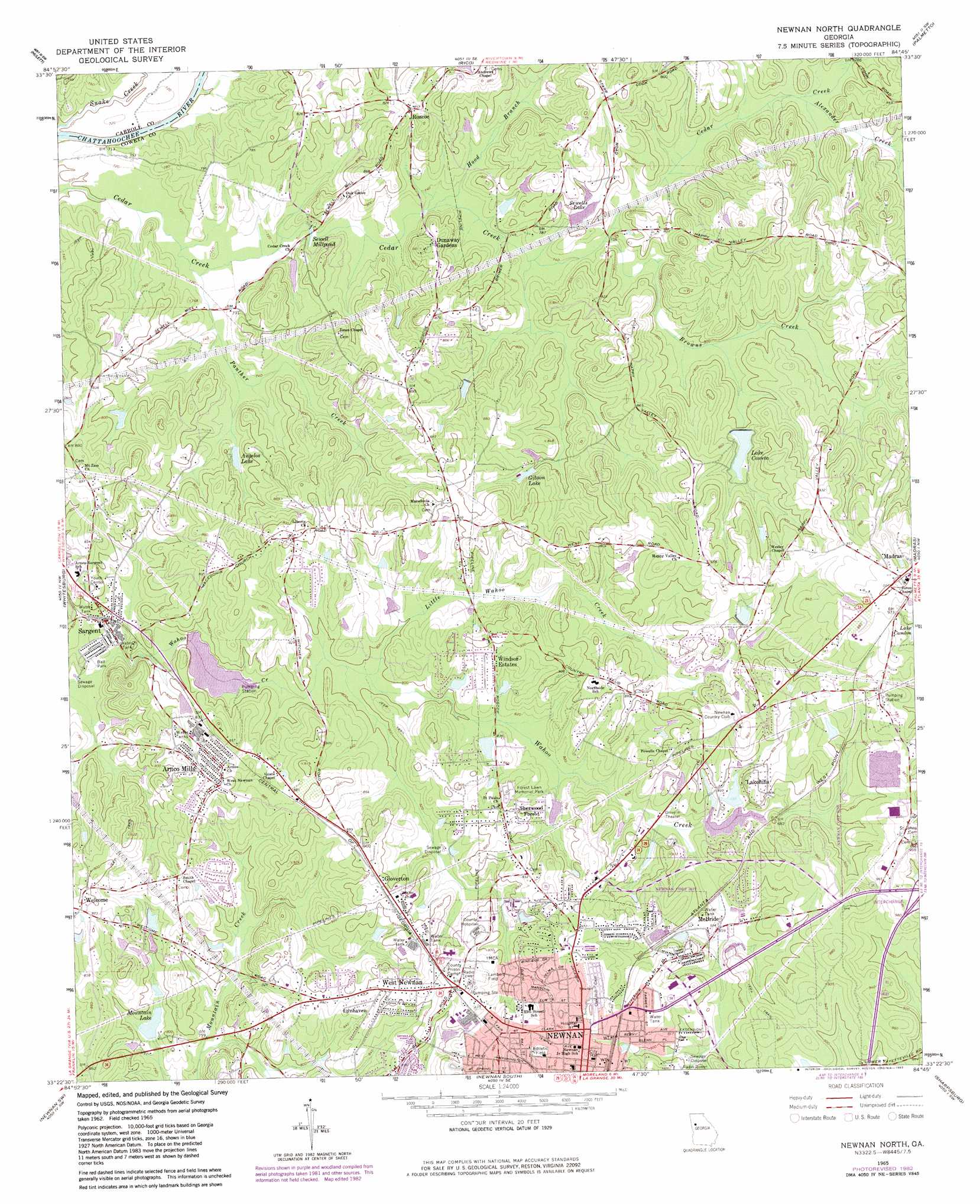
USGS Topo Quad 33084d7 - 1:24,000 scale
| Topo Map Name: | Newnan North |
| USGS Topo Quad ID: | 33084d7 |
| Print Size: | ca. 21 1/4" wide x 27" high |
| Southeast Coordinates: | 33.375° N latitude / 84.75° W longitude |
| Map Center Coordinates: | 33.4375° N latitude / 84.8125° W longitude |
| U.S. State: | GA |
| Filename: | o33084d7.jpg |
| Download Map JPG Image: | Newnan North topo map 1:24,000 scale |
| Map Type: | Topographic |
| Topo Series: | 7.5´ |
| Map Scale: | 1:24,000 |
| Source of Map Images: | United States Geological Survey (USGS) |
| Alternate Map Versions: |
Newnan North GA 1965, updated 1966 Download PDF Buy paper map Newnan North GA 1965, updated 1974 Download PDF Buy paper map Newnan North GA 1965, updated 1983 Download PDF Buy paper map Newnan North GA 2011 Download PDF Buy paper map Newnan North GA 2014 Download PDF Buy paper map |
1:24,000 Topo Quads surrounding Newnan North
Temple |
Villa Rica |
Winston |
Campbellton |
Ben Hill |
Carrollton |
Hulett |
Rico |
Palmetto |
Fairburn |
Lowell |
Whitesburg |
Newnan North |
Madras |
Tyrone |
Franklin |
Newnan Sw |
Newnan South |
Sharpsburg |
Senoia |
Hillcrest |
Hogansville |
Grantville |
Luthersville |
Haralson |
> Back to 33084a1 at 1:100,000 scale
> Back to 33084a1 at 1:250,000 scale
> Back to U.S. Topo Maps home
Newnan North topo map: Gazetteer
Newnan North: Airports
Humana Hospital-Newnan Heliport elevation 280m 918′Newnan Hospital Heliport elevation 298m 977′
Newnan North: Dams
Bibbs Lake Dam elevation 235m 770′Lake Coweta Dam elevation 251m 823′
Lake Hill Estates Dam elevation 264m 866′
Mountain Lake Dam elevation 233m 764′
Ross Lake Dam elevation 231m 757′
Newnan North: Parks
Lambert Field elevation 288m 944′Newnan Commercial Historic District elevation 299m 980′
Northwest Newnan Residential Historic District elevation 295m 967′
Platinum Point Historic District elevation 279m 915′
Newnan North: Populated Places
Arnco Mills elevation 269m 882′Creek Subdivision elevation 256m 839′
Dunaway Gardens elevation 257m 843′
Gloverton elevation 280m 918′
Hamilton Plantation Subdivision elevation 252m 826′
Lakehills elevation 271m 889′
Longwood Subdivision elevation 256m 839′
Lynhaven elevation 267m 875′
McBride elevation 260m 853′
Meadowview Mobile Home Park elevation 257m 843′
Newnan elevation 296m 971′
Newnan Pines elevation 269m 882′
Roscoe elevation 262m 859′
Sargent elevation 236m 774′
Sherwood Forest elevation 276m 905′
Wedgewood elevation 261m 856′
Welcome elevation 270m 885′
West Newnan elevation 277m 908′
Willow Creek Subdivision elevation 270m 885′
Windsor Estates elevation 270m 885′
Newnan North: Post Offices
Sargent Post Office elevation 234m 767′Newnan North: Reservoirs
Angelos Lake elevation 229m 751′Bibbs Lake elevation 235m 770′
Gibson Lake elevation 244m 800′
Lake Coweta elevation 244m 800′
Lake Coweta elevation 251m 823′
Lake Hill Estates Lake elevation 264m 866′
Mountain Lake elevation 233m 764′
Ross Lake elevation 231m 757′
Sewell Millpond elevation 222m 728′
Sewells Lake elevation 241m 790′
Newnan North: Streams
Alexander Creek elevation 232m 761′Browns Creek elevation 227m 744′
Hood Branch elevation 225m 738′
Little Wahoo Creek elevation 241m 790′
Panther Creek elevation 218m 715′
Newnan North digital topo map on disk
Buy this Newnan North topo map showing relief, roads, GPS coordinates and other geographical features, as a high-resolution digital map file on DVD: