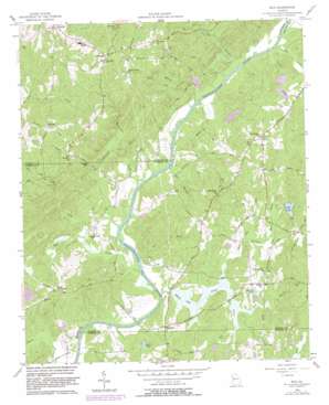
Rico Topo Map Georgia
To zoom in, hover over the map of Rico
USGS Topo Quad 33084e7 - 1:24,000 scale
| Topo Map Name: | Rico |
| USGS Topo Quad ID: | 33084e7 |
| Print Size: | ca. 21 1/4" wide x 27" high |
| Southeast Coordinates: | 33.5° N latitude / 84.75° W longitude |
| Map Center Coordinates: | 33.5625° N latitude / 84.8125° W longitude |
| U.S. State: | GA |
| Filename: | o33084e7.jpg |
| Download Map JPG Image: | Rico topo map 1:24,000 scale |
| Map Type: | Topographic |
| Topo Series: | 7.5´ |
| Map Scale: | 1:24,000 |
| Source of Map Images: | United States Geological Survey (USGS) |
| Alternate Map Versions: |
Rico GA 1958, updated 1958 Download PDF Buy paper map Rico GA 1958, updated 1969 Download PDF Buy paper map Rico GA 1958, updated 1983 Download PDF Buy paper map Rico GA 2011 Download PDF Buy paper map Rico GA 2014 Download PDF Buy paper map |
1:24,000 Topo Quads surrounding Rico
> Back to 33084e1 at 1:100,000 scale
> Back to 33084a1 at 1:250,000 scale
> Back to U.S. Topo Maps home
Rico topo map: Gazetteer
Rico: Basins
Devils Den elevation 280m 918′Rico: Crossings
Hutchesons Ferry elevation 212m 695′Morris Ferry (historical) elevation 219m 718′
Neal Ferry (historical) elevation 219m 718′
Rico: Dams
Barnes Lake Dam elevation 230m 754′Basket Creek Dam elevation 225m 738′
Carmichel Lake Dam elevation 225m 738′
Carnes Lake Dam elevation 230m 754′
Jones Ferry Road Dam elevation 221m 725′
Rico Lake Dam elevation 243m 797′
Sanders Lake Dam elevation 239m 784′
Smith Lake Dam elevation 230m 754′
Storey Lake Dam elevation 250m 820′
Wampum Lake Dam elevation 240m 787′
Rico: Populated Places
Basket Creek elevation 277m 908′Byers Crossroads elevation 264m 866′
Chattahoochee Hills elevation 249m 816′
Cheviot Hills elevation 298m 977′
Fairplay elevation 352m 1154′
Hannah elevation 328m 1076′
Hollis Heights elevation 331m 1085′
Links of Leith elevation 320m 1049′
McWhorter elevation 323m 1059′
Redwine elevation 244m 800′
Rico elevation 253m 830′
River West elevation 308m 1010′
Saint Andrews Country Club Estates elevation 345m 1131′
Rico: Reservoirs
Barnes Lake elevation 236m 774′Basket Creek Lake elevation 225m 738′
Carmichel Lake elevation 225m 738′
Carnes Lake elevation 230m 754′
Jones Ferry Road Lake elevation 221m 725′
Rico Lake elevation 243m 797′
Sanders Lake elevation 239m 784′
Smith Lake elevation 230m 754′
Starr Pond elevation 227m 744′
Storey Lake elevation 250m 820′
Wampum Lake elevation 240m 787′
Rico: Streams
Basket Creek elevation 219m 718′Bear Creek elevation 220m 721′
Dog River elevation 219m 718′
Dry Branch elevation 225m 738′
Hurricane Creek elevation 218m 715′
Lee Creek elevation 219m 718′
Little Wolf Creek elevation 222m 728′
Longino Creek elevation 225m 738′
Mill Branch elevation 219m 718′
Mill Creek elevation 255m 836′
Moss Creek elevation 227m 744′
Pine Creek elevation 213m 698′
Turkey Creek elevation 219m 718′
White Oak Creek elevation 213m 698′
Wolf Creek elevation 212m 695′
Rico digital topo map on disk
Buy this Rico topo map showing relief, roads, GPS coordinates and other geographical features, as a high-resolution digital map file on DVD:


