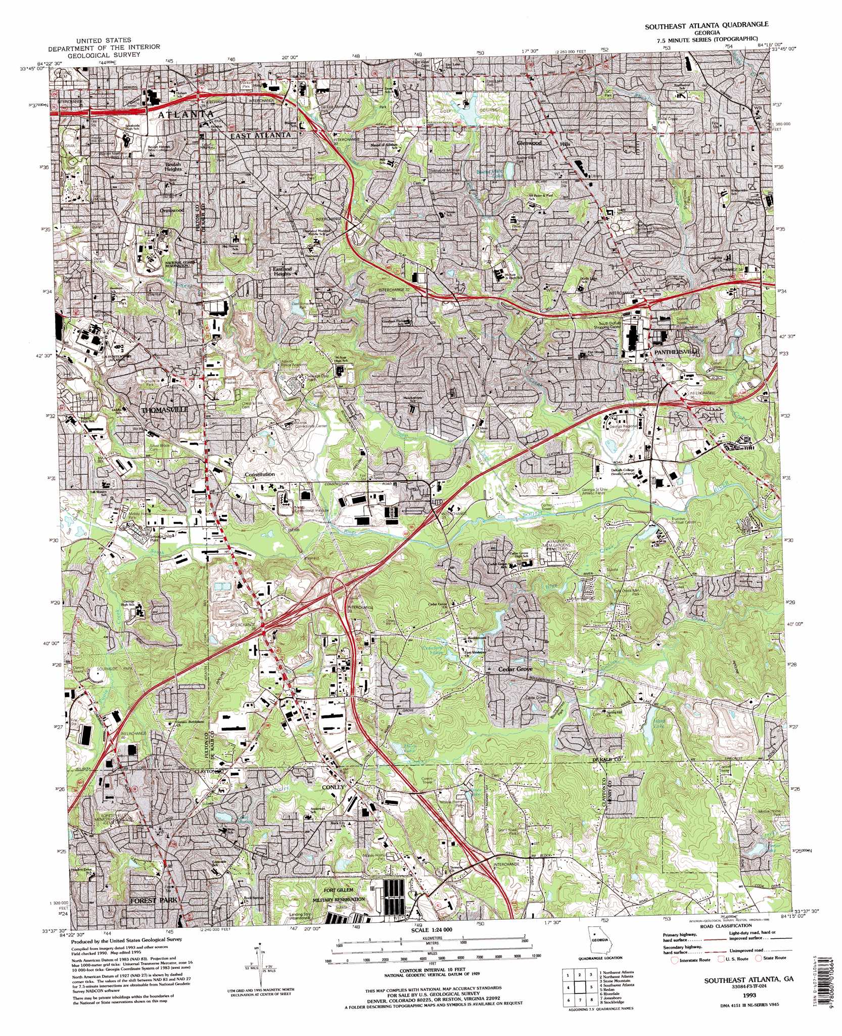
Southeast Atlanta Topo Map Georgia
To zoom in, hover over the map of Southeast Atlanta
USGS Topo Quad 33084f3 - 1:24,000 scale
| Topo Map Name: | Southeast Atlanta |
| USGS Topo Quad ID: | 33084f3 |
| Print Size: | ca. 21 1/4" wide x 27" high |
| Southeast Coordinates: | 33.625° N latitude / 84.25° W longitude |
| Map Center Coordinates: | 33.6875° N latitude / 84.3125° W longitude |
| U.S. State: | GA |
| Filename: | o33084f3.jpg |
| Download Map JPG Image: | Southeast Atlanta topo map 1:24,000 scale |
| Map Type: | Topographic |
| Topo Series: | 7.5´ |
| Map Scale: | 1:24,000 |
| Source of Map Images: | United States Geological Survey (USGS) |
| Alternate Map Versions: |
Conley GA 1954, updated 1956 Download PDF Buy paper map Conley GA 1954, updated 1965 Download PDF Buy paper map Southeast Atlanta GA 1954, updated 1969 Download PDF Buy paper map Southeast Atlanta GA 1954, updated 1975 Download PDF Buy paper map Southeast Atlanta GA 1954, updated 1983 Download PDF Buy paper map Southeast Atlanta GA 1993, updated 1995 Download PDF Buy paper map Southeast Atlanta GA 2011 Download PDF Buy paper map Southeast Atlanta GA 2014 Download PDF Buy paper map |
1:24,000 Topo Quads surrounding Southeast Atlanta
Marietta |
Sandy Springs |
Chamblee |
Norcross |
Luxomni |
Mableton |
Northwest Atlanta |
Northeast Atlanta |
Stone Mountain |
Snellville |
Ben Hill |
Southwest Atlanta |
Southeast Atlanta |
Redan |
Conyers |
Fairburn |
Riverdale |
Jonesboro |
Stockbridge |
Kelleytown |
Tyrone |
Fayetteville |
Hampton |
Mcdonough |
Ola |
> Back to 33084e1 at 1:100,000 scale
> Back to 33084a1 at 1:250,000 scale
> Back to U.S. Topo Maps home
Southeast Atlanta topo map: Gazetteer
Southeast Atlanta: Airports
Trico Heliport elevation 280m 918′Southeast Atlanta: Crossings
Exit 28 elevation 309m 1013′Exit 29 elevation 286m 938′
Exit 30 elevation 283m 928′
Exit 31 elevation 283m 928′
Exit 32 elevation 288m 944′
Exit 33 elevation 274m 898′
Exit 34 elevation 285m 935′
Interchange 36 elevation 252m 826′
Interchange 37 elevation 240m 787′
Interchange 39 elevation 279m 915′
Interchange 40 elevation 256m 839′
Southeast Atlanta: Dams
Buena Vista Lake Dam elevation 284m 931′Crawford Lake Dam elevation 240m 787′
East Lake Dam elevation 301m 987′
Glen Emerald Dam elevation 263m 862′
Hardin Lake Dam elevation 257m 843′
Lake Charlotte Dam elevation 241m 790′
Lake Murray Dam elevation 259m 849′
Lonnie Lake Dam elevation 268m 879′
Ward Lake Dam elevation 241m 790′
Southeast Atlanta: Lakes
Constitution Lake elevation 240m 787′Southeast Atlanta: Parks
Alexander Park elevation 264m 866′Belvedere Park elevation 270m 885′
Benteen Park elevation 295m 967′
Bouldercrest Park elevation 242m 793′
Brown Park elevation 302m 990′
Conley Park elevation 253m 830′
DeKalb Memorial County Park elevation 287m 941′
Derril Park elevation 291m 954′
East Lake Park elevation 295m 967′
Exchange Park elevation 247m 810′
Glen Emerald Park elevation 267m 875′
Glendale Park elevation 253m 830′
Glenwood Hills Park elevation 268m 879′
Grant Park elevation 289m 948′
Grant Park Historic District elevation 291m 954′
Grant Road Park elevation 279m 915′
Gresham Park elevation 245m 803′
Lake Charlotte Nature Preserve elevation 254m 833′
Longdale Park elevation 279m 915′
Mark Trail Park elevation 284m 931′
Misty Waters Park elevation 256m 839′
Panthersville Regional Athletic Center elevation 236m 774′
Panthersville Stadium elevation 234m 767′
Pine Circle Park elevation 273m 895′
Santa Monica Park elevation 277m 908′
Southside Park elevation 251m 823′
Starmount-McAfee Park elevation 280m 918′
Thomasville Heights Park elevation 288m 944′
W H T Walker Park elevation 303m 994′
Zoo Atlanta elevation 293m 961′
Southeast Atlanta: Populated Places
Ash Manor elevation 262m 859′Beulah Heights elevation 302m 990′
Blair Village elevation 252m 826′
Blue Creek elevation 259m 849′
Blue Creek Forest elevation 280m 918′
Briar Glen elevation 240m 787′
Brownwood elevation 300m 984′
Cabbage Town elevation 301m 987′
Cedar Grove elevation 262m 859′
Cedar Grove Acres elevation 271m 889′
Cedar Valley elevation 249m 816′
Cherokee Forest elevation 270m 885′
Conley elevation 260m 853′
Conley Downs elevation 244m 800′
Constitution elevation 257m 843′
Cornell elevation 260m 853′
Country Pine Estates elevation 258m 846′
Doral Park elevation 260m 853′
East Atlanta elevation 309m 1013′
Eastland Heights elevation 297m 974′
Elizabeth Park elevation 264m 866′
Fairfield Lakes elevation 276m 905′
Forest Ridge elevation 240m 787′
Glenwood Hills elevation 310m 1017′
Gresham Park elevation 275m 902′
Harry Pooles Mobile Home Park elevation 256m 839′
Henrico elevation 287m 941′
Hyde Park Mobile Home Park elevation 274m 898′
Lincolndale elevation 277m 908′
Manor Ridge Park elevation 297m 974′
Millrun elevation 268m 879′
Miramar elevation 244m 800′
Mountain View Plaza elevation 283m 928′
Norton (historical) elevation 245m 803′
Oak View Homes elevation 271m 889′
Ormewood elevation 294m 964′
Palisades Estates elevation 254m 833′
Panthersville elevation 271m 889′
Pinecrest Hills elevation 286m 938′
Pleasant Acres elevation 256m 839′
Ridgewood elevation 281m 921′
River Hills elevation 250m 820′
Riverside Station elevation 250m 820′
Rock Spring elevation 279m 915′
Rocklane Estates elevation 262m 859′
Rovena Acres elevation 235m 770′
Skyline Forest elevation 249m 816′
South Bend elevation 286m 938′
Sweetbriar elevation 277m 908′
Tamarack elevation 244m 800′
Tara Heights elevation 270m 885′
Thomasville elevation 279m 915′
Tolliver Heights elevation 262m 859′
Weather Wood elevation 251m 823′
Whitehall Forest Estates elevation 243m 797′
Wishing Well Hills elevation 275m 902′
Woodcrest elevation 259m 849′
Woodland Park elevation 281m 921′
Southeast Atlanta: Post Offices
Conley Post Office elevation 266m 872′East Atlanta Station Atlanta Post Office elevation 316m 1036′
South Decatur Station Decatur Post Office elevation 270m 885′
Southeast Atlanta: Reservoirs
Blue Lake elevation 232m 761′Bruce Lake elevation 251m 823′
Buena Vista Lake elevation 284m 931′
Crawford Lake elevation 240m 787′
Crawford Lakes elevation 257m 843′
East Lake elevation 301m 987′
Glen Emerald Lake elevation 263m 862′
Hales Lake elevation 244m 800′
Lake Charlotte elevation 241m 790′
Lake Murray elevation 259m 849′
Lonnie Lake elevation 265m 869′
Ward Lake elevation 241m 790′
Southeast Atlanta: Streams
Cobbs Creek elevation 226m 741′Doolittle Creek elevation 228m 748′
Intrenchment Creek elevation 234m 767′
Sugar Creek elevation 230m 754′
Veterans Creek elevation 252m 826′
Southeast Atlanta: Summits
Dabneys Hill elevation 317m 1040′Leggetts Hill elevation 319m 1046′
Southeast Atlanta digital topo map on disk
Buy this Southeast Atlanta topo map showing relief, roads, GPS coordinates and other geographical features, as a high-resolution digital map file on DVD: