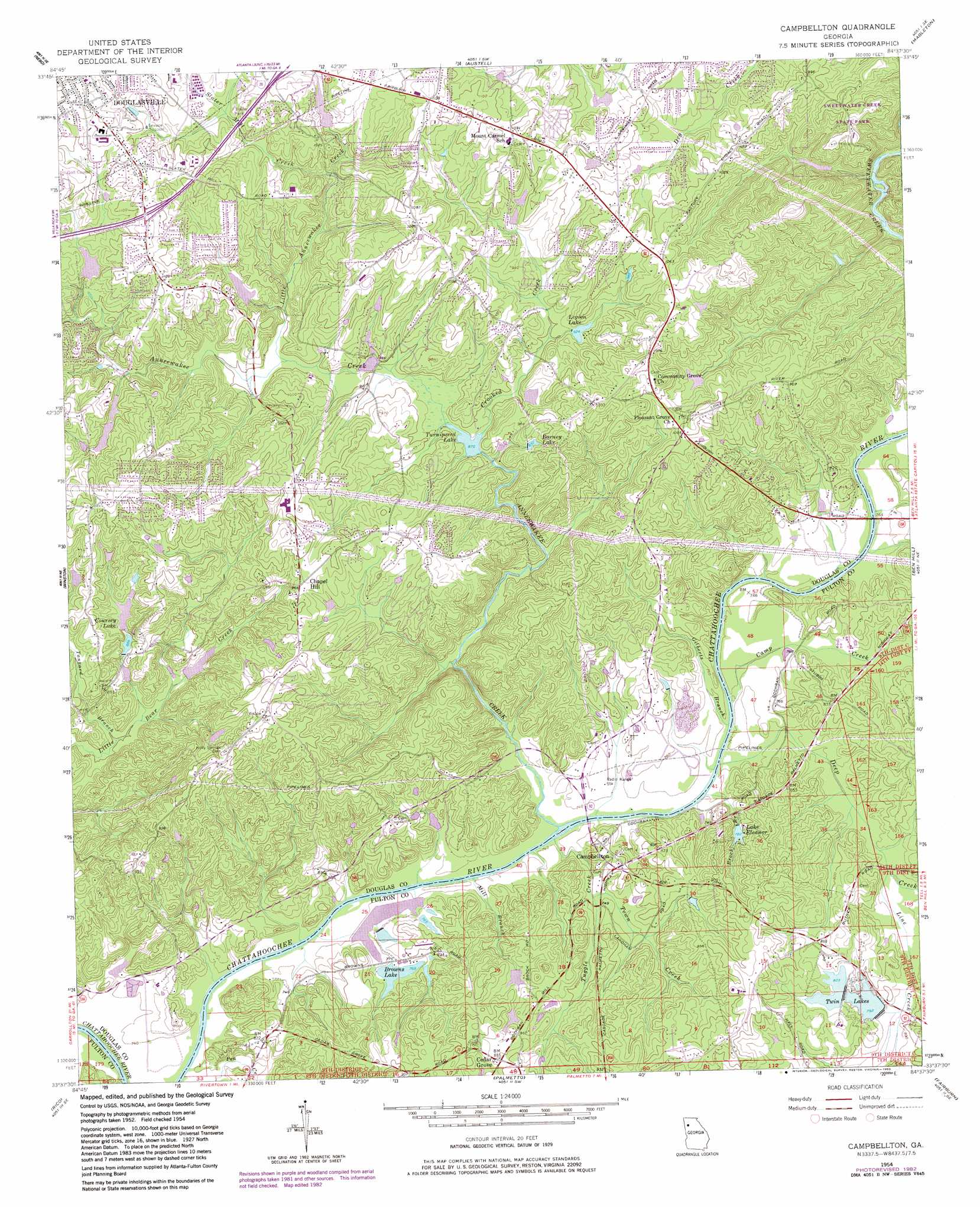
Campbellton Topo Map Georgia
To zoom in, hover over the map of Campbellton
USGS Topo Quad 33084f6 - 1:24,000 scale
| Topo Map Name: | Campbellton |
| USGS Topo Quad ID: | 33084f6 |
| Print Size: | ca. 21 1/4" wide x 27" high |
| Southeast Coordinates: | 33.625° N latitude / 84.625° W longitude |
| Map Center Coordinates: | 33.6875° N latitude / 84.6875° W longitude |
| U.S. State: | GA |
| Filename: | o33084f6.jpg |
| Download Map JPG Image: | Campbellton topo map 1:24,000 scale |
| Map Type: | Topographic |
| Topo Series: | 7.5´ |
| Map Scale: | 1:24,000 |
| Source of Map Images: | United States Geological Survey (USGS) |
| Alternate Map Versions: |
Campbellton GA 1954, updated 1956 Download PDF Buy paper map Campbellton GA 1954, updated 1968 Download PDF Buy paper map Campbellton GA 1954, updated 1969 Download PDF Buy paper map Campbellton GA 1954, updated 1983 Download PDF Buy paper map Campbellton GA 1999, updated 2003 Download PDF Buy paper map Campbellton GA 2011 Download PDF Buy paper map Campbellton GA 2014 Download PDF Buy paper map |
1:24,000 Topo Quads surrounding Campbellton
Yorkville |
Dallas |
Lost Mountain |
Marietta |
Sandy Springs |
New Georgia |
Nebo |
Austell |
Mableton |
Northwest Atlanta |
Villa Rica |
Winston |
Campbellton |
Ben Hill |
Southwest Atlanta |
Hulett |
Rico |
Palmetto |
Fairburn |
Riverdale |
Whitesburg |
Newnan North |
Madras |
Tyrone |
Fayetteville |
> Back to 33084e1 at 1:100,000 scale
> Back to 33084a1 at 1:250,000 scale
> Back to U.S. Topo Maps home
Campbellton topo map: Gazetteer
Campbellton: Airports
Chattahoochee Air Park elevation 223m 731′Miller Farm Airport elevation 225m 738′
Campbellton: Crossings
Campbellton Ferry (historical) elevation 226m 741′Exit 9 elevation 347m 1138′
Campbellton: Dams
Anneewakee Lake Dam elevation 271m 889′Austin North Lake Dam elevation 303m 994′
Big Lake Dam elevation 227m 744′
Browns Lake Dam elevation 232m 761′
Cohen Lake Dam elevation 278m 912′
Coursey Lake Dam elevation 281m 921′
Douglasville Lake Dam elevation 312m 1023′
Groover Lake Dam elevation 232m 761′
Leatherwood Lake Dam elevation 285m 935′
Legion Lake Dam elevation 282m 925′
Mid Lake Dam elevation 232m 761′
Monroe Lake Dam elevation 267m 875′
Patterson Lake Dam elevation 233m 764′
Shawnee Lake Dam elevation 305m 1000′
Small Browns Lake Dam elevation 234m 767′
Sweetwater Lake Dam elevation 252m 826′
Twin Lakes Dam Number Two elevation 241m 790′
Upper Twin Lake Dam elevation 241m 790′
Campbellton: Parks
Deer Lick Park elevation 316m 1036′Mount Carmel Recreation Park elevation 311m 1020′
Campbellton: Populated Places
Alta Vista elevation 347m 1138′Anneewakee elevation 268m 879′
Anneewakee Estates elevation 332m 1089′
Anneewakee Heights elevation 333m 1092′
Blair Heights elevation 294m 964′
Britt elevation 310m 1017′
Brown Subdivision elevation 345m 1131′
Campbellton elevation 247m 810′
Captains Quarters elevation 338m 1108′
Carmel Chase elevation 288m 944′
Carmel Farms elevation 283m 928′
Cedar Grove elevation 270m 885′
Chapel Hill elevation 295m 967′
Chestnut Log elevation 284m 931′
Corn Creek Cove elevation 251m 823′
Creek Indian elevation 237m 777′
Daniel Subdivision elevation 337m 1105′
Del Ridge elevation 304m 997′
Dogwood Acres elevation 296m 971′
Dorris elevation 343m 1125′
Doublegate elevation 303m 994′
Douglas Estates elevation 287m 941′
Evergreen elevation 349m 1145′
Five Notch Acres elevation 268m 879′
Flagview Mobile Home Park elevation 329m 1079′
Flowers Estates elevation 319m 1046′
Glen Villa elevation 286m 938′
Heritage Valley elevation 324m 1062′
Hilderbrand elevation 281m 921′
Holland Manor elevation 311m 1020′
Hyde Park elevation 311m 1020′
Ivey Estates elevation 321m 1053′
Longview Estates elevation 303m 994′
Meadowview elevation 299m 980′
Mecca (historical) elevation 281m 921′
Rebel Trail elevation 302m 990′
Reynolds Estates elevation 344m 1128′
Rolling Hills elevation 318m 1043′
Salem elevation 359m 1177′
Shawnee Lake Estates elevation 316m 1036′
Shelby Forest elevation 319m 1046′
South Ridge elevation 305m 1000′
Southern Manor elevation 294m 964′
Springhill Estates elevation 291m 954′
Springwood Village elevation 324m 1062′
Stewart Woods elevation 328m 1076′
Tara Woods elevation 289m 948′
The Meadows North elevation 280m 918′
Timber Valley elevation 326m 1069′
Warren Heights elevation 330m 1082′
Western Pines elevation 336m 1102′
Whispering Woods Estates elevation 301m 987′
Windwood Village elevation 327m 1072′
Campbellton: Post Offices
Douglasville Post Office elevation 356m 1167′Campbellton: Reservoirs
Anneewakee Lake elevation 271m 889′Austin North Lake elevation 303m 994′
Barney Lake elevation 285m 935′
Big Lake elevation 227m 744′
Browns Lake elevation 232m 761′
Cohen Lake elevation 278m 912′
Coursey Lake elevation 281m 921′
Douglasville Lake elevation 312m 1023′
Groover Lake elevation 232m 761′
Lake Eleanor elevation 239m 784′
Leatherwood Lake elevation 285m 935′
Legion Lake elevation 282m 925′
Mid Lake elevation 232m 761′
Monroe Lake elevation 267m 875′
Patterson Lake elevation 233m 764′
Shawnee Lake elevation 305m 1000′
Small Browns Lake elevation 234m 767′
Sweetwater Lake elevation 252m 826′
Turnipseed Lake elevation 265m 869′
Twin Lakes elevation 241m 790′
Twin Lakes Number 2 elevation 241m 790′
Upper Twin Lake elevation 241m 790′
Campbellton: Streams
Anneewakee Creek elevation 222m 728′Brock Branch elevation 225m 738′
Camp Creek elevation 225m 738′
Crooked Creek elevation 266m 872′
Deep Creek elevation 223m 731′
Gilberts Branch elevation 225m 738′
Line Creek elevation 227m 744′
Little Anneewakee Creek elevation 271m 889′
Mill Branch elevation 222m 728′
Slater Mill Creek elevation 284m 931′
Tanyard Branch elevation 243m 797′
Town Creek elevation 229m 751′
Tuggle Creek elevation 222m 728′
Campbellton digital topo map on disk
Buy this Campbellton topo map showing relief, roads, GPS coordinates and other geographical features, as a high-resolution digital map file on DVD: