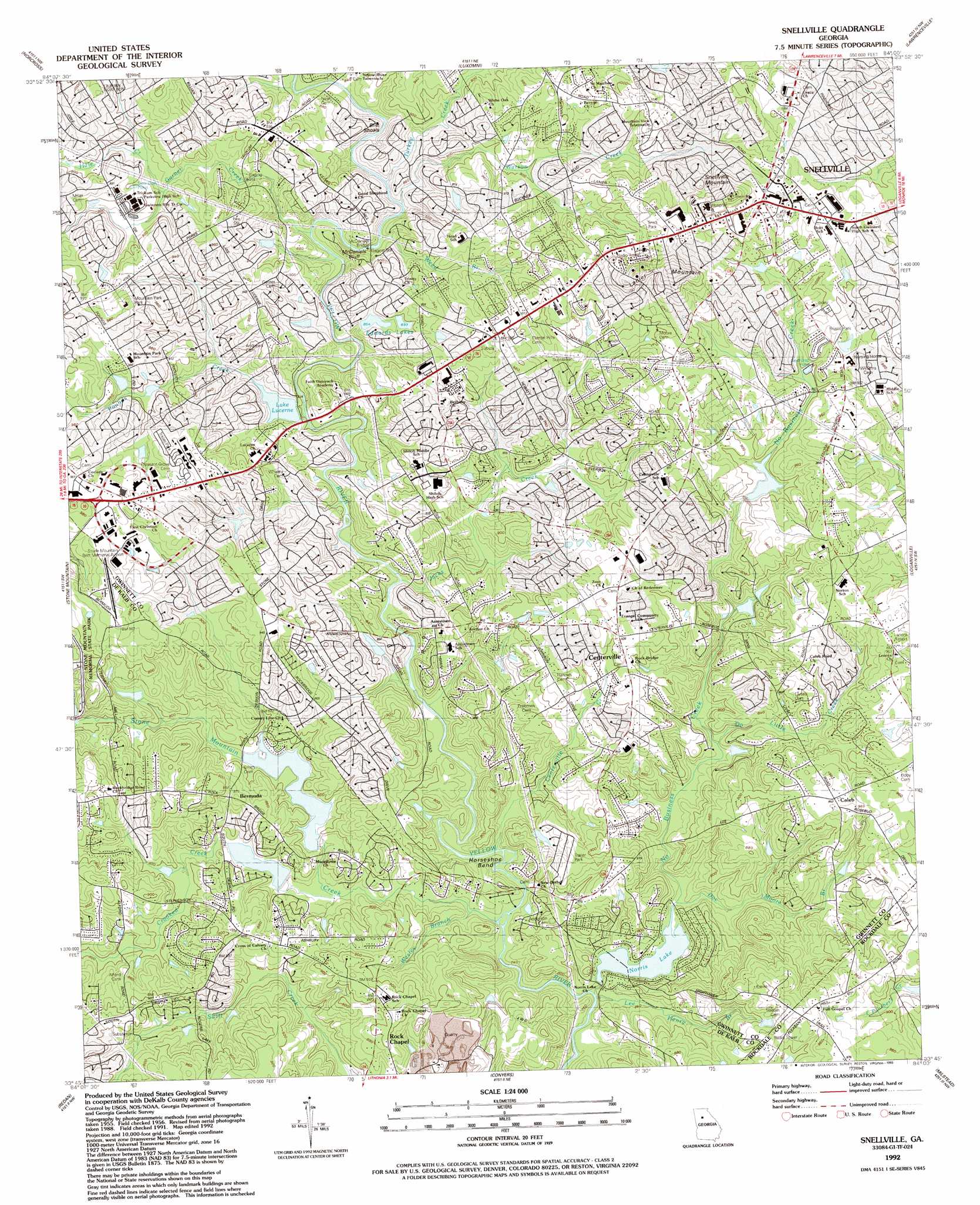
Snellville Topo Map Georgia
To zoom in, hover over the map of Snellville
USGS Topo Quad 33084g1 - 1:24,000 scale
| Topo Map Name: | Snellville |
| USGS Topo Quad ID: | 33084g1 |
| Print Size: | ca. 21 1/4" wide x 27" high |
| Southeast Coordinates: | 33.75° N latitude / 84° W longitude |
| Map Center Coordinates: | 33.8125° N latitude / 84.0625° W longitude |
| U.S. State: | GA |
| Filename: | o33084g1.jpg |
| Download Map JPG Image: | Snellville topo map 1:24,000 scale |
| Map Type: | Topographic |
| Topo Series: | 7.5´ |
| Map Scale: | 1:24,000 |
| Source of Map Images: | United States Geological Survey (USGS) |
| Alternate Map Versions: |
Snellville GA 1956, updated 1957 Download PDF Buy paper map Snellville GA 1956, updated 1969 Download PDF Buy paper map Snellville GA 1956, updated 1970 Download PDF Buy paper map Snellville GA 1956, updated 1974 Download PDF Buy paper map Snellville GA 1956, updated 1983 Download PDF Buy paper map Snellville GA 1992, updated 1993 Download PDF Buy paper map Snellville GA 1999, updated 2003 Download PDF Buy paper map Snellville GA 2011 Download PDF Buy paper map Snellville GA 2014 Download PDF Buy paper map |
1:24,000 Topo Quads surrounding Snellville
Roswell |
Duluth |
Suwanee |
Hog Mountain |
Auburn |
Chamblee |
Norcross |
Luxomni |
Lawrenceville |
Bold Springs |
Northeast Atlanta |
Stone Mountain |
Snellville |
Loganville |
Between |
Southeast Atlanta |
Redan |
Conyers |
Milstead |
Jersey |
Jonesboro |
Stockbridge |
Kelleytown |
Porterdale |
Covington |
> Back to 33084e1 at 1:100,000 scale
> Back to 33084a1 at 1:250,000 scale
> Back to U.S. Topo Maps home
Snellville topo map: Gazetteer
Snellville: Airports
Caleb Heliport elevation 288m 944′Stone Mountain-Britt Memorial Airport elevation 300m 984′
Snellville: Bars
Britt Shoals elevation 247m 810′Snellville: Bends
Horseshoe Bend elevation 223m 731′Snellville: Bridges
Annistown Bridge elevation 237m 777′McDaniels Bridge elevation 247m 810′
Snellville: Cliffs
McDaniels Bluff elevation 268m 879′Snellville: Dams
Allen Dam elevation 276m 905′Edwards Lake West Dam elevation 259m 849′
Kilpatrick Dam elevation 251m 823′
Norris Lake Dam elevation 222m 728′
Opossum Lake Dam elevation 246m 807′
Pylant Dam elevation 278m 912′
Ramsden Lake Dam elevation 254m 833′
Stone Mountain Park Lake Dam elevation 276m 905′
Snellville: Lakes
Lake Lucerne elevation 247m 810′Snellville: Parks
Brisco Park elevation 299m 980′Mountain Park Park elevation 292m 958′
Rock Chapel Park elevation 278m 912′
Snell Park elevation 324m 1062′
Snellville: Populated Places
Arbor Ridge elevation 272m 892′Bermuda elevation 269m 882′
Brandington Forest elevation 245m 803′
Caleb elevation 291m 954′
Camp Creek Estates elevation 307m 1007′
Castlewood Mobile Home Park elevation 271m 889′
Cedar Creek elevation 276m 905′
Centerville elevation 282m 925′
Corinth Hills elevation 300m 984′
Country Square elevation 287m 941′
Cumberland Forest elevation 300m 984′
Gwinnstone elevation 312m 1023′
Hickory Hills elevation 306m 1003′
Innsbrook elevation 278m 912′
Innsbrook West elevation 287m 941′
Lake Lucerne Estates elevation 281m 921′
Laurel Creek elevation 268m 879′
Lenora elevation 289m 948′
Lochwolde elevation 258m 846′
Mason Woods elevation 286m 938′
McGuires (historical) elevation 233m 764′
Meadow Hills elevation 254m 833′
Monterey Acres elevation 288m 944′
Mountain Cove elevation 242m 793′
Norris Lake Shores elevation 243m 797′
Quinn Ridge elevation 273m 895′
Rainbow Estates elevation 300m 984′
Rivermist elevation 271m 889′
Rock Bridge elevation 239m 784′
Rock Chapel elevation 283m 928′
Rockbridge elevation 269m 882′
Sardum (historical) elevation 292m 958′
Scenic Mountain elevation 280m 918′
Shiloh Farms elevation 260m 853′
Smoke Creek Mobile Home Park elevation 252m 826′
Snellville elevation 323m 1059′
Stonemont elevation 282m 925′
Summer Place elevation 285m 935′
Swift Creek elevation 273m 895′
The Landings elevation 269m 882′
The Moorings elevation 256m 839′
Timber Trace elevation 292m 958′
Twin Village elevation 289m 948′
Williams Place elevation 323m 1059′
Yellow River (historical) elevation 259m 849′
Snellville: Post Offices
Snellville Post Office elevation 324m 1062′Snellville: Reservoirs
Allen Lake elevation 276m 905′Edwards Lake West elevation 259m 849′
Edwards Lakes elevation 267m 875′
Kilpatrick Lake elevation 251m 823′
Norris Lake elevation 222m 728′
Pylant Lake elevation 278m 912′
Ramsden Lake elevation 254m 833′
Stone Mountain Park Lake elevation 276m 905′
Snellville: Streams
Centerville Creek elevation 221m 725′Crooked Creek elevation 227m 744′
Do Little Creek elevation 231m 757′
Doc Moore Branch elevation 218m 715′
Garner Creek elevation 246m 807′
Hale Creek elevation 262m 859′
Jacks Creek elevation 237m 777′
Lee Henry Branch elevation 218m 715′
No Business Creek elevation 225m 738′
Pounds Creek elevation 247m 810′
Stone Mountain Creek elevation 220m 721′
Turkey Creek elevation 247m 810′
Watson Creek elevation 248m 813′
Weed Branch elevation 247m 810′
Wesley Branch elevation 223m 731′
Snellville: Summits
Lanier Mountain elevation 344m 1128′Rock Chapel Mountain elevation 280m 918′
Snellville Mountain elevation 353m 1158′
Snellville digital topo map on disk
Buy this Snellville topo map showing relief, roads, GPS coordinates and other geographical features, as a high-resolution digital map file on DVD: