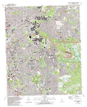
Stone Mountain Topo Map Georgia
To zoom in, hover over the map of Stone Mountain
USGS Topo Quad 33084g2 - 1:24,000 scale
| Topo Map Name: | Stone Mountain |
| USGS Topo Quad ID: | 33084g2 |
| Print Size: | ca. 21 1/4" wide x 27" high |
| Southeast Coordinates: | 33.75° N latitude / 84.125° W longitude |
| Map Center Coordinates: | 33.8125° N latitude / 84.1875° W longitude |
| U.S. State: | GA |
| Filename: | o33084g2.jpg |
| Download Map JPG Image: | Stone Mountain topo map 1:24,000 scale |
| Map Type: | Topographic |
| Topo Series: | 7.5´ |
| Map Scale: | 1:24,000 |
| Source of Map Images: | United States Geological Survey (USGS) |
| Alternate Map Versions: |
Stone Mountain GA 1956, updated 1957 Download PDF Buy paper map Stone Mountain GA 1956, updated 1965 Download PDF Buy paper map Stone Mountain GA 1956, updated 1970 Download PDF Buy paper map Stone Mountain GA 1956, updated 1974 Download PDF Buy paper map Stone Mountain GA 1956, updated 1981 Download PDF Buy paper map Stone Mountain GA 1956, updated 1983 Download PDF Buy paper map Stone Mountain GA 1992, updated 1992 Download PDF Buy paper map Stone Mountain GA 1997, updated 1999 Download PDF Buy paper map Stone Mountain GA 2011 Download PDF Buy paper map Stone Mountain GA 2014 Download PDF Buy paper map |
1:24,000 Topo Quads surrounding Stone Mountain
> Back to 33084e1 at 1:100,000 scale
> Back to 33084a1 at 1:250,000 scale
> Back to U.S. Topo Maps home
Stone Mountain topo map: Gazetteer
Stone Mountain: Airports
DeKalb Police Department Heliport elevation 301m 987′Smith Heliport elevation 317m 1040′
Stone Mountain: Crossings
Interchange 28 elevation 323m 1059′Interchange 32 elevation 292m 958′
Interchange 33 elevation 293m 961′
Stone Mountain: Dams
Henson Dam elevation 283m 928′Hugh Spivey Lake Dam elevation 287m 941′
Kenilworth Dam elevation 280m 918′
Lake Erine Dam elevation 298m 977′
Lake Ivanhoe Dam elevation 305m 1000′
Lake To-Lani Dam elevation 263m 862′
Lanford Lake Dam elevation 273m 895′
Mystery Valley Dam elevation 251m 823′
Rice Lake Dam elevation 266m 872′
Rockbridge Dam elevation 293m 961′
Rutland Dam One elevation 267m 875′
Rutland Dam Two elevation 290m 951′
Sheppard Road Lake Dam elevation 274m 898′
Stone Mountain Park Dam-North Dam elevation 258m 846′
Stone Mountain Park Dam-South Dam elevation 250m 820′
Village Oak Dam elevation 256m 839′
Stone Mountain: Lakes
Durham Lake elevation 273m 895′Greenwood Lakes elevation 287m 941′
Howell Lake elevation 263m 862′
Lake Louise elevation 290m 951′
Lake Michele elevation 278m 912′
Mill Lake elevation 266m 872′
Rock Bridge Lake elevation 293m 961′
Venable Lake elevation 250m 820′
Stone Mountain: Parks
Emmie Smith County Park elevation 284m 931′Fourty Oaks Park elevation 279m 915′
Hairston Park elevation 267m 875′
Henderson Park elevation 299m 980′
Kelley C Cofer Park elevation 330m 1082′
McCurdy Park elevation 299m 980′
Milan Park elevation 285m 935′
Montreal Park elevation 317m 1040′
Randolph Medlock Park elevation 306m 1003′
Silver Hill Park elevation 305m 1000′
Stone Mountain Memorial elevation 351m 1151′
Stone Mountain State Memorial Park elevation 473m 1551′
Tucker Park elevation 323m 1059′
Vets Park elevation 295m 967′
W C Studdard Park elevation 276m 905′
Wade Walker County Park elevation 292m 958′
Stone Mountain: Populated Places
Brentwood elevation 293m 961′Brook Hollow elevation 317m 1040′
Caldwell (historical) elevation 285m 935′
Carrefour Place elevation 307m 1007′
Clarkston elevation 311m 1020′
Four Winds elevation 313m 1026′
Hunters Glen elevation 300m 984′
Idlewood Acres elevation 314m 1030′
Kings Mountain elevation 301m 987′
Lanford elevation 307m 1007′
Montreal elevation 305m 1000′
Mountain Brooke elevation 311m 1020′
Mountain Park elevation 312m 1023′
Mountain Woods elevation 328m 1076′
Oakengate elevation 319m 1046′
Patriots Hill elevation 304m 997′
Pine Lake elevation 289m 948′
Silver Ridge elevation 292m 958′
Smoke Rise elevation 310m 1017′
Sterling Acres elevation 323m 1059′
Stone Mill Run elevation 299m 980′
Stone Mountain elevation 318m 1043′
Trickem elevation 304m 997′
Tucker elevation 342m 1122′
Tucker Mobile Home Park elevation 300m 984′
Wilshire elevation 316m 1036′
Stone Mountain: Post Offices
Clarkston Post Office elevation 303m 994′Memorial Square Post Office elevation 290m 951′
Pine Lake Post Office elevation 312m 1023′
Stone Mountain Post Office elevation 294m 964′
Stone Mountain Post Office elevation 317m 1040′
Tucker Post Office elevation 335m 1099′
Stone Mountain: Reservoirs
Henson Lake elevation 283m 928′Hugh Spivey Lake elevation 287m 941′
Kenilworth Lake elevation 280m 918′
Lake Arrowhead elevation 270m 885′
Lake Charles elevation 293m 961′
Lake Erin elevation 298m 977′
Lake Ivanhoe elevation 305m 1000′
Lake To-Lani elevation 263m 862′
Lanford Lake elevation 273m 895′
Mystery Valley Lake elevation 251m 823′
Pine Lake elevation 283m 928′
Rice Lake elevation 266m 872′
Rockbridge Lake elevation 294m 964′
Rutland Lake One elevation 267m 875′
Rutland Lake Two elevation 290m 951′
Sheppard Road Lake elevation 274m 898′
Stone Mountain Lake elevation 250m 820′
Stone Mountain Park Lake-North elevation 258m 846′
Stone Mountain Park Lake-South elevation 250m 820′
Twin Brothers Lake elevation 299m 980′
Village Oak Lake elevation 256m 839′
Stone Mountain: Streams
Indian Creek elevation 262m 859′Little Stone Mountain Creek elevation 251m 823′
Stone Mountain: Summits
Stone Mountain elevation 514m 1686′Stone Mountain digital topo map on disk
Buy this Stone Mountain topo map showing relief, roads, GPS coordinates and other geographical features, as a high-resolution digital map file on DVD:


