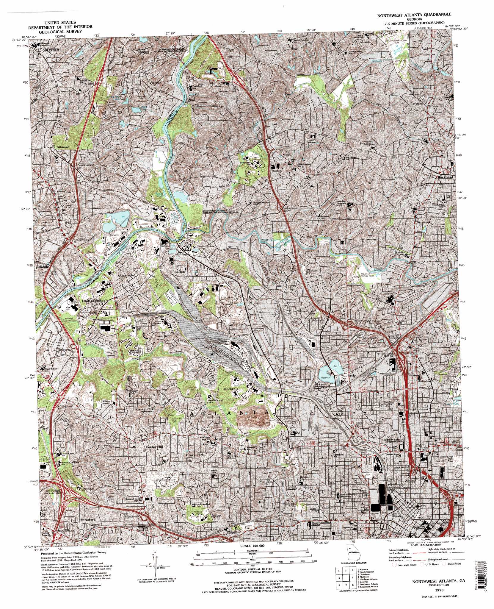
Northwest Atlanta Topo Map Georgia
To zoom in, hover over the map of Northwest Atlanta
USGS Topo Quad 33084g4 - 1:24,000 scale
| Topo Map Name: | Northwest Atlanta |
| USGS Topo Quad ID: | 33084g4 |
| Print Size: | ca. 21 1/4" wide x 27" high |
| Southeast Coordinates: | 33.75° N latitude / 84.375° W longitude |
| Map Center Coordinates: | 33.8125° N latitude / 84.4375° W longitude |
| U.S. State: | GA |
| Filename: | o33084g4.jpg |
| Download Map JPG Image: | Northwest Atlanta topo map 1:24,000 scale |
| Map Type: | Topographic |
| Topo Series: | 7.5´ |
| Map Scale: | 1:24,000 |
| Source of Map Images: | United States Geological Survey (USGS) |
| Alternate Map Versions: |
Bolton GA 1954, updated 1957 Download PDF Buy paper map Bolton GA 1954, updated 1965 Download PDF Buy paper map Northwest Atlanta GA 1954, updated 1970 Download PDF Buy paper map Northwest Atlanta GA 1954, updated 1974 Download PDF Buy paper map Northwest Atlanta GA 1954, updated 1979 Download PDF Buy paper map Northwest Atlanta GA 1954, updated 1988 Download PDF Buy paper map Northwest Atlanta GA 1993, updated 1995 Download PDF Buy paper map Northwest Atlanta GA 1997, updated 1999 Download PDF Buy paper map Northwest Atlanta GA 2011 Download PDF Buy paper map Northwest Atlanta GA 2014 Download PDF Buy paper map |
1:24,000 Topo Quads surrounding Northwest Atlanta
Acworth |
Kennesaw |
Mountain Park |
Roswell |
Duluth |
Lost Mountain |
Marietta |
Sandy Springs |
Chamblee |
Norcross |
Austell |
Mableton |
Northwest Atlanta |
Northeast Atlanta |
Stone Mountain |
Campbellton |
Ben Hill |
Southwest Atlanta |
Southeast Atlanta |
Redan |
Palmetto |
Fairburn |
Riverdale |
Jonesboro |
Stockbridge |
> Back to 33084e1 at 1:100,000 scale
> Back to 33084a1 at 1:250,000 scale
> Back to U.S. Topo Maps home
Northwest Atlanta topo map: Gazetteer
Northwest Atlanta: Airports
400 Colony Square Heliport elevation 298m 977′Bridge Building Heliport elevation 265m 869′
Crawford W Long Memorial Hospital Heliport elevation 311m 1020′
Skypad Heliport elevation 285m 935′
The Coca Cola Company Heliport elevation 300m 984′
WSB-TV Heliport elevation 287m 941′
Northwest Atlanta: Bridges
Collins Bridge elevation 226m 741′Northwest Atlanta: Crossings
De Foor Ferry (historical) elevation 226m 741′Exit 94 elevation 306m 1003′
Interchange 10 elevation 263m 862′
Interchange 100 elevation 296m 971′
Interchange 101 elevation 282m 925′
Interchange 102 elevation 268m 879′
Interchange 103 elevation 266m 872′
Interchange 104 elevation 273m 895′
Interchange 105 elevation 282m 925′
Interchange 106 elevation 266m 872′
Interchange 107 elevation 246m 807′
Interchange 108 elevation 265m 869′
Interchange 11 elevation 280m 918′
Interchange 12 elevation 323m 1059′
Interchange 15 elevation 261m 856′
Interchange 16 elevation 299m 980′
Interchange 17 elevation 326m 1069′
Interchange 25 elevation 261m 856′
Interchange 6 elevation 267m 875′
Interchange 7 elevation 260m 853′
Interchange 8 elevation 262m 859′
Interchange 9 elevation 236m 774′
Interchange 95 elevation 309m 1013′
Interchange 96 elevation 299m 980′
Interchange 98 elevation 305m 1000′
Interchange 99 elevation 290m 951′
Pace Ferry (historical) elevation 229m 751′
Northwest Atlanta: Dams
Ash Pond Four Dam elevation 233m 764′Atlanta City Water Works Reservoir Number One Dam elevation 297m 974′
Atlanta City Water Works Reservoir Number Two Dam elevation 296m 971′
North Paces Lake Dam elevation 290m 951′
Paces Lake Dam elevation 245m 803′
Northwest Atlanta: Islands
Long Island elevation 230m 754′Northwest Atlanta: Parks
Alexander Park elevation 255m 836′Anderson Park elevation 299m 980′
Ansley Park elevation 255m 836′
Ansley Park Historic District elevation 282m 925′
Ardmore Park elevation 251m 823′
Atlanta Memorial Park elevation 240m 787′
Bedford Pine Park elevation 291m 954′
Big Heart Park elevation 320m 1049′
Bill Moore Tennis Complex elevation 274m 898′
Bobby Dodd Stadium elevation 279m 915′
Brookview Park elevation 244m 800′
Brookwood Hills Historic District elevation 256m 839′
Burger Bowl Field elevation 285m 935′
Butler Street Park elevation 305m 1000′
Carey Park elevation 277m 908′
Centennial Olympic Park elevation 305m 1000′
Center Hill Park elevation 259m 849′
Chastain Memorial Park elevation 248m 813′
Civic Center Park elevation 310m 1017′
Dale Creek Park elevation 272m 892′
Dale Way Park elevation 248m 813′
Edwin Place Park elevation 261m 856′
English Park elevation 263m 862′
Eubanks Park elevation 265m 869′
Fairlie-Poplar Historic District elevation 322m 1056′
Fox Theatre Historic District elevation 312m 1023′
Garden Hills Historic District elevation 292m 958′
Garden Hills Park elevation 262m 859′
Georgia Institute of Technology Historic District elevation 302m 990′
Grant Field elevation 279m 915′
Griffin Track elevation 276m 905′
Grove Park elevation 271m 889′
Gun Club Park elevation 272m 892′
Harwell Heights Park elevation 274m 898′
Henry Ivy Park elevation 319m 1046′
Hotel Row Historic District elevation 324m 1062′
Hurt Park elevation 310m 1017′
J F Kennedy Park elevation 288m 944′
Lincoln Homes Park elevation 234m 767′
Loring Heights Park elevation 257m 843′
Maddox Park elevation 279m 915′
Margaret Mitchell Square elevation 325m 1066′
Mozley Park elevation 301m 987′
Oglethorpe Park (historical) elevation 292m 958′
Omni Coliseum (historical) elevation 313m 1026′
Parkside Drive Park elevation 252m 826′
Peachtree Hills Park elevation 245m 803′
Peyton Park elevation 265m 869′
Philips Arena elevation 313m 1026′
Pine Grove Park elevation 254m 833′
Plaza Park elevation 320m 1049′
Rockdale Park elevation 255m 836′
Rose Bowl Field elevation 276m 905′
Sibley Park elevation 268m 879′
Spring Valley Road Park elevation 249m 816′
Sunny Brook Park elevation 265m 869′
Sweet Auburn Historic District elevation 300m 984′
Tanyardd Creek Park elevation 243m 797′
Techwood Homes Historic District elevation 286m 938′
Underground Atlanta Historic District elevation 320m 1049′
Underwood Hills Park elevation 267m 875′
Washington Park elevation 289m 948′
West Bolling Road Park elevation 275m 902′
William T Knight Park elevation 277m 908′
Williams Park elevation 276m 905′
Winn Park elevation 274m 898′
Woodruff Park elevation 322m 1056′
Woodruff Park elevation 297m 974′
Woodward Way Park elevation 265m 869′
Yonah Park elevation 274m 898′
Northwest Atlanta: Populated Places
Ansley Park elevation 282m 925′Atlanta Station Number 4 Fire Station elevation 311m 1020′
Battle Hill Haven elevation 316m 1036′
Bellwood elevation 289m 948′
Bolton elevation 240m 787′
Brooklyn elevation 314m 1030′
Brookwood elevation 274m 898′
Brookwood Hills elevation 265m 869′
Buckhead elevation 307m 1007′
Carey Park elevation 300m 984′
Center Hill elevation 289m 948′
Chattahoochee elevation 271m 889′
Ellen elevation 277m 908′
Five Points elevation 319m 1046′
Forest Acres elevation 252m 826′
Gilmore elevation 308m 1010′
Grove Park elevation 278m 912′
Hills Park elevation 251m 823′
Magnolia elevation 254m 833′
Miralia elevation 260m 853′
Northside Park elevation 281m 921′
Oakdale elevation 252m 826′
Payton (historical) elevation 267m 875′
Ridgewood Heights elevation 249m 816′
Rivermeade elevation 235m 770′
Riverside elevation 259m 849′
Rockdale elevation 286m 938′
Shermantown elevation 296m 971′
Simsville elevation 272m 892′
Slabtown (historical) elevation 302m 990′
Snake Nation (historical) elevation 325m 1066′
Stratford elevation 286m 938′
Tilford elevation 262m 859′
Vine City elevation 298m 977′
Vinings elevation 279m 915′
Westover Plantation elevation 236m 774′
Woodward elevation 287m 941′
Northwest Atlanta: Post Offices
Atlanta Downtown Post Office elevation 319m 1046′Civic Center Station Atlanta Post Office elevation 296m 971′
CNN Center Post Office elevation 317m 1040′
Federal Center Post Office elevation 316m 1036′
Georgia Institute of Technology Branch Post Office elevation 283m 928′
Howell Mill Post Office elevation 288m 944′
Martech Post Office elevation 305m 1000′
Martech Station Atlanta Post Office elevation 308m 1010′
Midtown Post Office elevation 291m 954′
Morris Brown Post Office elevation 300m 984′
Peachtree Center Post Office elevation 322m 1056′
Northwest Atlanta: Reservoirs
Ash Pond Four elevation 233m 764′Atlanta City Water Works Reservoir Number One elevation 297m 974′
Atlanta City Water Works Reservoir Number Two elevation 296m 971′
North Paces Lake elevation 290m 951′
Paces Lake elevation 245m 803′
Northwest Atlanta: Streams
A D Williams Creek elevation 231m 757′Nancy Creek elevation 230m 754′
Peachtree Creek elevation 226m 741′
Proctor Creek elevation 238m 780′
Northwest Atlanta: Summits
Mount Wilkinson elevation 299m 980′Northwest Atlanta digital topo map on disk
Buy this Northwest Atlanta topo map showing relief, roads, GPS coordinates and other geographical features, as a high-resolution digital map file on DVD: