Mableton Topo Map Georgia
To zoom in, hover over the map of Mableton
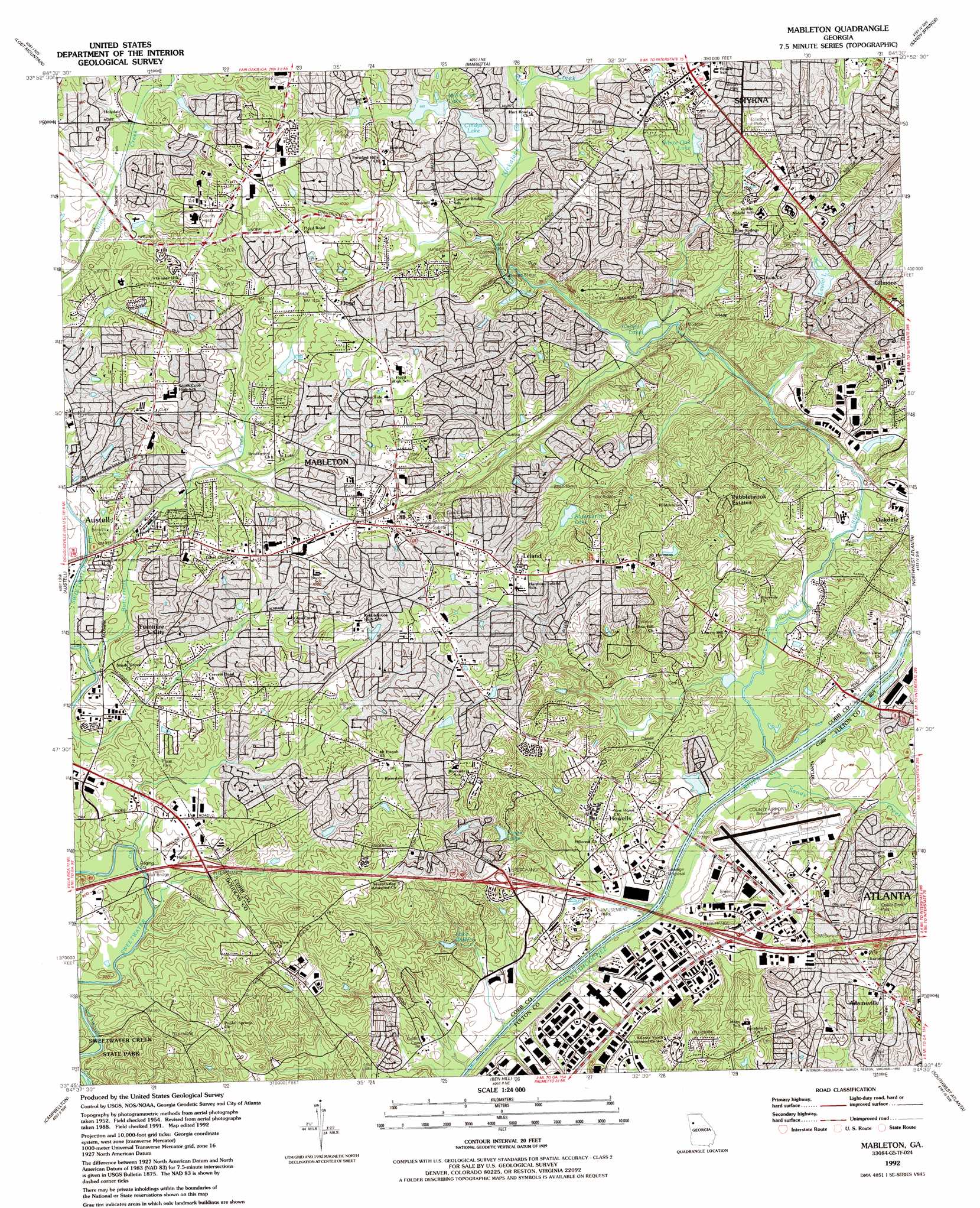
USGS Topo Quad 33084g5 - 1:24,000 scale
| Topo Map Name: | Mableton |
| USGS Topo Quad ID: | 33084g5 |
| Print Size: | ca. 21 1/4" wide x 27" high |
| Southeast Coordinates: | 33.75° N latitude / 84.5° W longitude |
| Map Center Coordinates: | 33.8125° N latitude / 84.5625° W longitude |
| U.S. State: | GA |
| Filename: | o33084g5.jpg |
| Download Map JPG Image: | Mableton topo map 1:24,000 scale |
| Map Type: | Topographic |
| Topo Series: | 7.5´ |
| Map Scale: | 1:24,000 |
| Source of Map Images: | United States Geological Survey (USGS) |
| Alternate Map Versions: |
Mableton GA 1954, updated 1956 Download PDF Buy paper map Mableton GA 1954, updated 1962 Download PDF Buy paper map Mableton GA 1954, updated 1969 Download PDF Buy paper map Mableton GA 1954, updated 1974 Download PDF Buy paper map Mableton GA 1954, updated 1983 Download PDF Buy paper map Mableton GA 1992, updated 1992 Download PDF Buy paper map Mableton GA 2011 Download PDF Buy paper map Mableton GA 2014 Download PDF Buy paper map |
1:24,000 Topo Quads surrounding Mableton
Burnt Hickory Ridge |
Acworth |
Kennesaw |
Mountain Park |
Roswell |
Dallas |
Lost Mountain |
Marietta |
Sandy Springs |
Chamblee |
Nebo |
Austell |
Mableton |
Northwest Atlanta |
Northeast Atlanta |
Winston |
Campbellton |
Ben Hill |
Southwest Atlanta |
Southeast Atlanta |
Rico |
Palmetto |
Fairburn |
Riverdale |
Jonesboro |
> Back to 33084e1 at 1:100,000 scale
> Back to 33084a1 at 1:250,000 scale
> Back to U.S. Topo Maps home
Mableton topo map: Gazetteer
Mableton: Airports
Cobb General Hospital Heliport elevation 315m 1033′Fulton County Airport-Brown Field elevation 248m 813′
HCA Parkway Medical Center Heliport elevation 276m 905′
Smyrna Hospital Heliport elevation 301m 987′
Mableton: Bridges
Blair Bridge elevation 261m 856′Concord Covered Bridge elevation 266m 872′
Garretts Bridge elevation 223m 731′
Mableton: Crossings
Bakers Ferry (historical) elevation 223m 731′Greens Ferry (historical) elevation 223m 731′
Interchange 12 elevation 279m 915′
Interchange 13 elevation 255m 836′
Interchange 14 elevation 250m 820′
Nelsons Ferry (historical) elevation 223m 731′
Turner Ferry (historical) elevation 223m 731′
Mableton: Dams
Cardinal Lake Dam elevation 286m 938′Castle Lake Dam elevation 230m 754′
Daniell Dam elevation 285m 935′
Glore Lake Dam elevation 294m 964′
Glore Lake Dam elevation 306m 1003′
Goodwin Lake Dam elevation 228m 748′
Hicks Lake Dam elevation 299m 980′
Lake Starling Dam elevation 312m 1023′
Laurel Lake Dam elevation 263m 862′
Mill Creek Lake Dam elevation 287m 941′
Queens Lake Dam elevation 259m 849′
Seybert Lake Dam elevation 300m 984′
Summerlin Lake Dam elevation 281m 921′
Mableton: Parks
Askew Park elevation 309m 1013′Collier Drive Park elevation 269m 882′
Hurt Road Park elevation 306m 1003′
Lake Court Park elevation 301m 987′
Lions Park elevation 293m 961′
Nickajack Park elevation 237m 777′
Rhyne Park elevation 274m 898′
Six Flags Over Georgia elevation 238m 780′
Thompson Park elevation 270m 885′
Tolleson Park elevation 303m 994′
Trademore Park elevation 277m 908′
Wallace Park elevation 296m 971′
Wilson Mill Park elevation 276m 905′
Mableton: Populated Places
Adamsville elevation 288m 944′Bankhead Courts elevation 234m 767′
Blackhawk Hills elevation 283m 928′
Blue Ridge Manor elevation 335m 1099′
Boulder Park elevation 274m 898′
Boulder Vista elevation 305m 1000′
Brenda View elevation 287m 941′
Brookside Village elevation 238m 780′
Camerons Crossing elevation 287m 941′
Cardell elevation 245m 803′
Carroll Heights elevation 255m 836′
Castlewood Estates elevation 244m 800′
Cherokee Hills elevation 325m 1066′
Cherokee Trail elevation 301m 987′
Cheyenne Estates elevation 276m 905′
Country Manor elevation 322m 1056′
Creelwood elevation 284m 931′
Creelwood Trailer Park elevation 297m 974′
Dunn Hill elevation 299m 980′
Ellison Estates elevation 301m 987′
Fairburn Heights elevation 264m 866′
Flagstone elevation 308m 1010′
Floyd elevation 308m 1010′
Ford Heights elevation 295m 967′
Furniture City elevation 294m 964′
Gardner Woods elevation 310m 1017′
Gordon Acres elevation 305m 1000′
Gordon Heights elevation 324m 1062′
Gordon Hills Estates elevation 324m 1062′
Gordon Woods elevation 328m 1076′
Greenbrook elevation 287m 941′
Hembree Hills elevation 314m 1030′
Hillcrest Valley elevation 254m 833′
Howard elevation 323m 1059′
Ivey Terrace elevation 256m 839′
Ivy Point elevation 292m 958′
James Acres elevation 311m 1020′
Johnstons Crossing elevation 243m 797′
Kennedy elevation 306m 1003′
Knox Springs Estates elevation 324m 1062′
La Bama elevation 309m 1013′
Lakeside elevation 323m 1059′
Leland elevation 309m 1013′
Lizzie (historical) elevation 243m 797′
Lodge West elevation 266m 872′
Mableton elevation 298m 977′
Mount Pisgah Estates elevation 305m 1000′
Nickajack (historical) elevation 260m 853′
Normandy Forest elevation 285m 935′
Nottingham elevation 298m 977′
Oak Hill elevation 288m 944′
Oakhill elevation 300m 984′
Pebblebrook Estates elevation 330m 1082′
Pine Creek elevation 284m 931′
Pineview elevation 295m 967′
Pisgah Forest elevation 303m 994′
Pleasant Acres elevation 314m 1030′
Quails Nest elevation 300m 984′
Queens Lake Estates elevation 255m 836′
Saddleback Ridge elevation 333m 1092′
Sherwood Estates elevation 296m 971′
Songwood elevation 301m 987′
Summit Ridge elevation 321m 1053′
The Village Mobile Home Park elevation 255m 836′
Vel Manor elevation 263m 862′
Whisperwoods elevation 328m 1076′
Witt Acres elevation 288m 944′
Mableton: Post Offices
Concord Square Post Office elevation 317m 1040′Mableton Post Office elevation 318m 1043′
Mableton: Reservoirs
Cardinal Lake elevation 286m 938′Castle Lake elevation 230m 754′
Cindys Lake elevation 277m 908′
Cooper Lake elevation 250m 820′
Daniell Lake elevation 285m 935′
Glore Lake elevation 294m 964′
Glore Lake elevation 306m 1003′
Goodwin Lake elevation 228m 748′
Hicks Lake elevation 299m 980′
Jetts Lake elevation 232m 761′
Kings Lake elevation 271m 889′
Lake Ca Reca elevation 250m 820′
Lake Starling elevation 312m 1023′
Laurel Lake elevation 267m 875′
Mill Creek Lake elevation 287m 941′
Queens Lake elevation 259m 849′
Seybert Lake elevation 300m 984′
Summerlin Lake elevation 281m 921′
White Oak Lake elevation 293m 961′
Mableton: Streams
Butternut Creek elevation 268m 879′Nickajack Creek elevation 224m 734′
Sandy Creek elevation 226m 741′
Mableton digital topo map on disk
Buy this Mableton topo map showing relief, roads, GPS coordinates and other geographical features, as a high-resolution digital map file on DVD: